

- Support portal
- Evaluation Kits and partner products
u-blox Support
- Product documentation
Documentation
- Investor relations
Investor relations
Technology
|
31 Aug 2021
Overcoming GNSS errors with PPP-RTK to achieve decimeter or even centimeter level positioning in real time.

Global navigation satellite systems (GNSS) have transformed our world, enabling anyone to quickly and easily pinpoint their location anywhere on the planet. High precision GNSS positioning has hit the mass market, driven by new, highly integrated GNSS receivers and, crucially, a new generation of GNSS correction services.
Today, several millions of devices stand to benefit from high precision positioning solutions that deliver accuracies down to the centimeter level, in applications ranging from unmanned service robots to automotive applications such as driving automation and lane-accurate navigation solutions to industrial and prosumer drones.
Unaided, GNSS-based positioning is subject to a variety of errors that limit achievable accuracies to several meters. These errors are caused primarily by satellite clock drift, slight deviations from the predicted orbits, or signal delays incurred in the charged ionosphere and the troposphere. GNSS correction services use a variety of techniques, delivery mechanisms, and core technologies to overcome these errors and achieve decimeter or even centimeter-level positioning accuracy.
*Offer applies to new Thingstream accounts only.
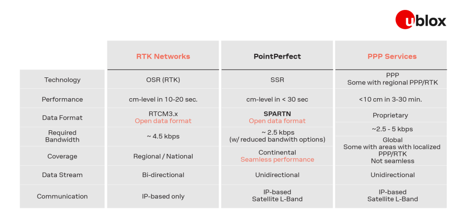
Conventional real-time kinematic (RTK) GNSS correction services determine the magnitude of the GNSS errors by observing the satellite signals from one or several fixed reference stations. They then use IP-based communication to transfer the lump sum of all observed errors, which remains valid within a roughly 30 kilometer radius from the nearest base station, to the end user. RTK-based solutions require two-way communication between the GNSS receiver and the GNSS correction service provider and achieve centimeter-level positioning accuracy in ten to twenty seconds.
Alternatively, precise point positioning (PPP) GNSS correction services broadcast a model of the GNSS errors that remains valid across vast geographical expanses. Because it only requires unidirectional communication (IP-based or via satellite L-band), the service can be delivered to any number of users. Conventional PPP high precision positioning can take three minutes to half an hour to deliver a position estimate with below 10 centimeter accuracy, making it a viable solution for static applications such as surveying but a poor fit for more dynamic ones, such as drones, micromobility, precision agriculture, and others.
In recent years, these established approaches to determining GNSS corrections and delivering them have been combined into PPP-RTK GNSS corrections services (sometimes also referred to as state space representation (SSR) correction services) that deliver the best of both worlds: combining accuracy close to that of RTK and quick initialization times with the broadcast nature of PPP. Like PPP-based solutions, they rely on a model of GNSS errors with broad geographical validity and broadcast the different GNSS error components (or states) using one-way communication. The GNSS receivers then compute the GNSS corrections for their specific location. Additional statistical information can further support the algorithms used by the GNSS receiver.
With the emergence of a mass market for high precision GNSS solutions, demand for scalable high accuracy positioning solutions is picking up. PPP-RTK GNSS correction services present an ideal solution for several reasons:

PointPerfect is u-blox’s advanced PPP-RTK GNSS augmentation data service, designed to deliver centimeter-level positioning accuracy with convergence within seconds. PointPerfect is specifically designed to meet the needs of emerging mass market applications that need real-time, reliable, and accurate positioning with minimal bandwidth requirements, and is immediately available with uniform coverage on a continental scale.
*Offer applies to new Thingstream accounts only.
PointPerfect offers verified GNSS correction data for several GNSS constellations and all large-scale environmental effects that impact GNSS signals to deliver an augmentation service that can be trusted. The service is available via our easy-to-use Thingstream IoT service delivery platform, which eliminates complexities and allows users to engage more efficiently, reducing time to market. This combination lowers barriers to adoption and supports scaled-up high precision positioning solutions, even in segments where such solutions would previously have been considered impractical.
Learn more in the PointPerfect product summary.
See the different ways to evaluate F9 and PointPerfect.
Modern positioning systems require a combination of low bandwidth, high accuracy, availability, reliability, and integrity of communication between service providers and end users. The SPARTN format is an industry-driven messaging standard designed to meet these requirements. SPARTN is an evolution that combines the advantages of the state representation with modernized communication protocol fundamentals, resulting in a bandwidth-optimized solution that reduces transmitting costs for end users.
The highly reliable, lightweight MQTT protocol is vastly more efficient than HTTP when transmitting many messages on a single connection. Lower overhead and simplified messaging transport mean less data and lower transmission cost. MQTT protocol is scalable: it is as easy to broadcast a message to a million devices as it is to send to just one.
You asked, we answered. We’re excited to share the news: PointPerfect is now also available via NTRIP protocol. NTRIP offers a new alternative for you to more easily connect and use PointPerfect. Learn more about PointPerfect NTRIP delivery.
PointPerfect is delivered through Thingstream IoT service delivery platform, a cloud-based delivery platform and administration interface for enterprise IoT services. Pressure tested and proven to support the delivery of billions of messages, the intuitive interface provides a self-serve environment from which users have autonomy to manage IoT device fleets, manage billing, monitor events, and have complete API control of functionality.
In addition to a traditional subscription-based approach, we offer flexible service plans tuned to address various customers, use cases, and applications. Thingstream enables a frictionless business experience, eliminating complexities and allowing users to engage more efficiently and reduce time to market. The combination serves as an inflection point in the market evolution of high precision GNSS solutions.
PointPerfect is available with uniform coverage on a continental scale, including up to 12 nautical miles (22 kilometers) off coastlines. The reference network is being continuously expanded in response to market demand.
Delivered redundantly via both mobile internet and satellite L-band communication, PointPerfect offers 99.9% uptime availability, backed by a warranty and expert support.
PointPerfect integrates seamlessly into u-blox’s comprehensive silicon-to-cloud set of solutions and offerings. These include industry-leading, high precision, multi-band GNSS receiver modules, connectivity hardware, and advanced GNSS augmentation services. All technology building blocks are sourced in house, giving us full span of control without the external dependencies that can be barriers to responsiveness or call longevity into question.
Because PointPerfect is based on open SPARTN format, its use is not restricted to a single hardware manufacturer. In this way, customers have the flexibility to make hardware and services selections that optimize overall return on investment.


