Consultation:
Clearbrook to Roborough Multi-Use Trail
Devon County Council held a public consultation between 11 March 2022 and 6 May 2022 on a proposed multi-use trail between Clearbrook and Roborough. This consultation has now closed and you can view a detailed analysis of responses in the Clearbrook to Roborough Public Consultation Report. Some headlines from the report are provided below:
- The overwhelming majority (89%, 809) of respondents supported the principle of a new multi-use trail, with the key reason for this being the unsafe existing walking and cycling provision. Other reasons for support include the increased opportunities for active travel and tackling climate change.
- 76% of respondents reported that Route B (adjacent to Plymouth Leat) would serve them best, while 24% preferred Route A (adjacent to the A386).
- Exercise and leisure would be the most popular reasons for using either route. 24% of respondents would use the more direct Route A for commuting, and 23% of respondents would use Route B to travel to work.
This path would be an extension of the existing Drake’s Trail and would fill in a gap in the leisure and active travel network along the A386 corridor. You can watch a recording of the presentation given at the Clearbrook to Roborough Multi-Use Trail Public Consultation Webinar on 16 March 2022.
-
Background
Multi-use paths are important elements of the Department for Transport’s (DfT) Cycling and Walking Investment Strategy and active and sustainable travel have a key role to play in the Transport Decarbonisation Plan.
In line with these national guidance documents, Devon County Council’s Cycling and Multi-Use Trail Network Strategy sets out the county’s ambition to continue developing a segregated high-quality, multi-use network of trails promoting healthy lifestyles and access for all.
A new multi-use trail between Clearbrook and Roborough is being developed as part of this commitment.
-
The current situation
A386

A386 The existing travel network between Tavistock and Plymouth primarily consists of the A386. This is a busy route with average daily traffic of 16,000-18,000 vehicles. This road is mainly used by cars, and the volume of motorised traffic is likely to increase as nearby housing developments allocated in the Joint Local Plan are built out.
Consequently, the A386 is not suited to providing a safe and accessible route for walkers, cyclists and other non-motorised users. The road does not have suitable footways and is not an appropriate width to allow cyclists and vehicles to share road space.
Drake’s Trail

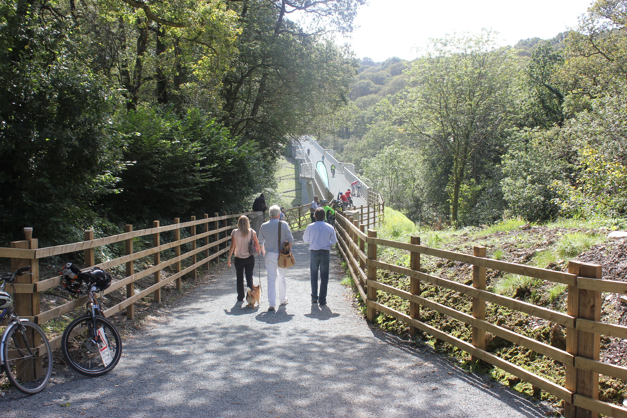
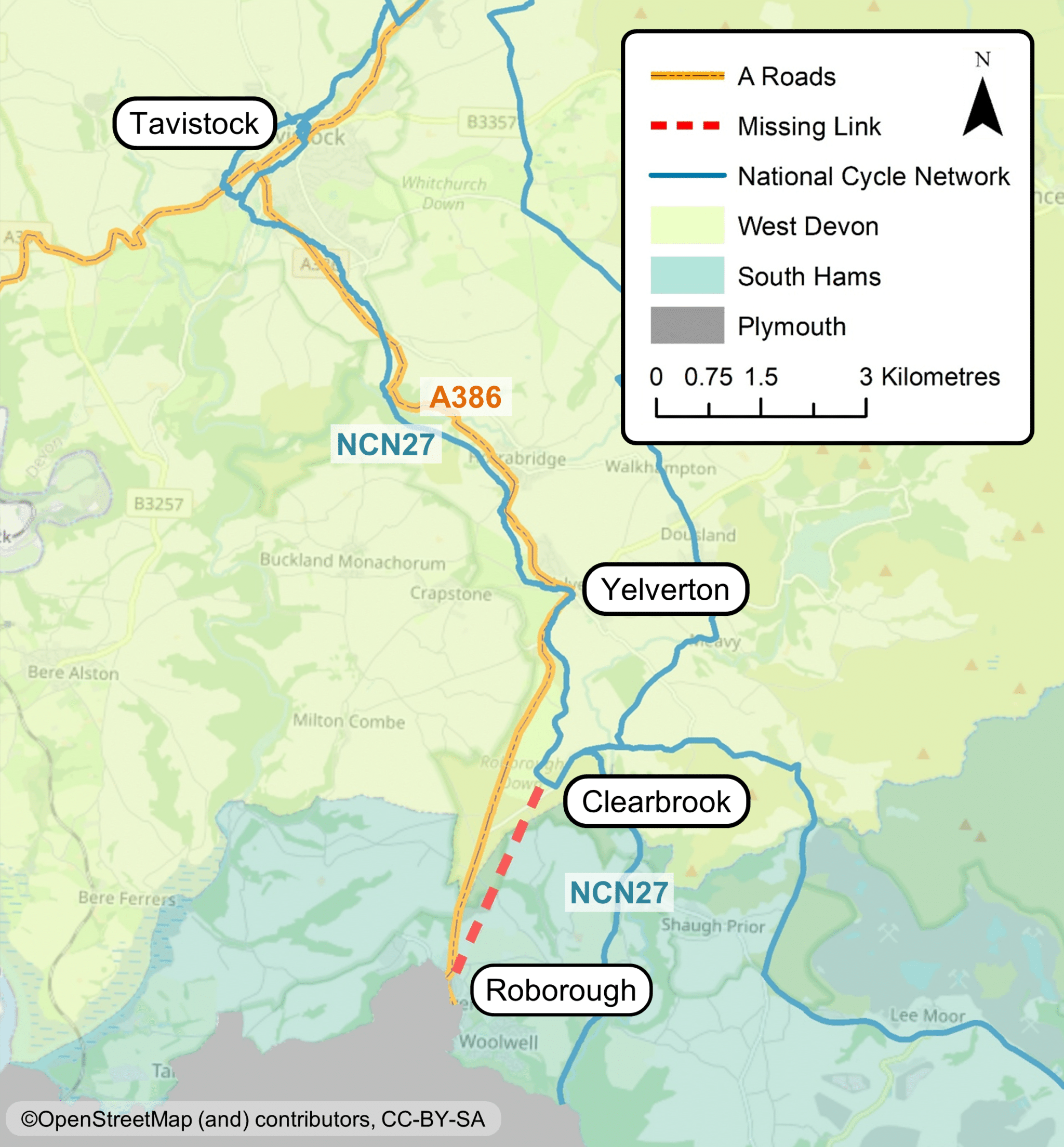
Gem Bridge, Drake’s Trail Parallel to the A386, Drake’s Trail (National Cycle Network 27) offers high-quality non-motorised provision from Tavistock through Yelverton to Clearbrook and onwards to eastern Plymouth.
This trail is suitable for a range of users of all abilities and increases accessibility to the stunning natural environment. However, the trail currently heads east at Clearbrook Leat car park and connects into Plympton in the east of Plymouth, bypassing important employment, residential and new development areas at Woolwell in the north of the city.

Key destinations in the north of Plymouth -
Options identified
To address this missing link into northern Plymouth, feasibility work is being undertaken into the extension of Drake’s Trail (NCN27) from Clearbrook to Roborough.
As a result, two high-level options have been developed with the aim of providing a route that is inclusive and accessible to a wide audience. It is important to note that at this early stage of development the routes suggested below are purely indicative and subject to further changes. Both options are being designed in line with the DfT’s Local Transport Note 1/20 which identifies the five key principles of:
- attractiveness
- cohesion
- directness
- safety
- comfort

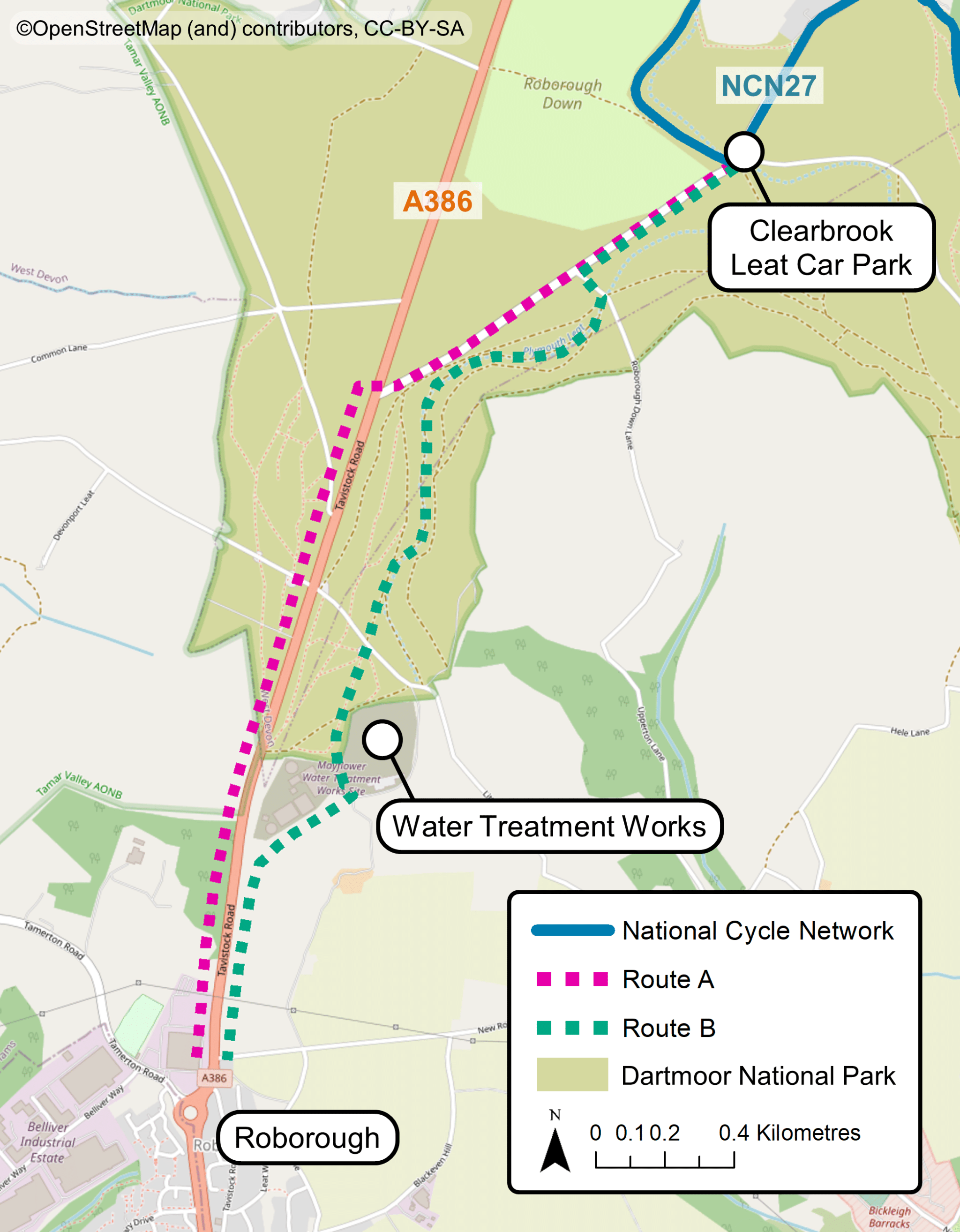
Indicative route options Route A
- Follows Clearbrook Road southwest from Clearbrook Leat car park to the A386.
- Crosses the A386 at the Clearbrook junction.
- Heads south along the western verge of the A386 to reach Roborough.
- Approximately 3.3km in length.
Route B
- Follows Clearbrook Road southwest from Clearbrook Leat car park to the existing footpath adjacent to Plymouth Leat.
- Heads south along Plymouth Leat and then around the South West Water Treatment Works.
- Travels south across agricultural fields parallel to the A386 to reach Roborough.
- Approximately 3.5km in length.
Route comparison
Advantages Disadvantages Route A Shortest and most direct route
Smaller footprint of impacts on the local environment
Traffic noise and visibility from A386
Less attractive route likely to have less appeal to a range of users
Crossings of A386 required
Route B Limited noise and visibility from A386
Attractive route across Dartmoor likely to appeal to a range of users
Slightly longer route
Bigger footprint of impact on local environment
Water Treatment Works may provide a routing constraint
Shared issues
- Relevant planning consents will be required for construction.
- Third-Party land will be required.
- Additional consents will be required to construct on Dartmoor National Park/Common Land.
- Funding stream for construction is yet to be identified.
-
Frequently asked questions
What is LTN1/20?
Local Transport Note 1/20 was published by the Department for Transport (DfT) in 2021 and contains new requirements for the construction of walking and cycling infrastructure. Within this document are 5 key principles: attractiveness, cohesion, directness, safety and comfort. To gain approval and funding projects must be LTN1/20 compliant.
Who is this proposed multi-use trail being designed for?
Multi-use trails are designed to offer an opportunity for walkers, cyclists, wheel-chair users, and others, to be active and enjoy the outdoors. LTN1/20 states that routes should be as inclusive and as accessible to as wide an audience as possible: ‘infrastructure should be accessible to everyone from 8 to 80 and beyond: it should be planned and designed for everyone.’
Through this consultation we are hoping to gain an understanding of who potential users might be and how they might use the route. This will help inform how the scheme progresses.
Is there an option for a trail to easily be provided on the existing A386 verge?
The section of Route A between Dartmoor Diner and Clearbrook junction proposes a multi-use trail located on the existing A386 verge.
However, these verges do not belong to Devon County Council and therefore negotiations with third party landowners are required. The verges also fall within Dartmoor National Park. This means that any proposals are subject to Dartmoor National Park’s planning approval process, which includes going before a Planning Inspectorate.
The section between Dartmoor Diner and Roborough has significant constraints on both sides of the A386. These need time to be investigated further and discussions with landowners are required to develop the design and preferred option.
How wide would the multi-use trail be?
A 3-metre-wide path would be provided as recommended by LTN1/20. There may be some instances where physical constraints mean this is not possible, however the design process will try to reduce these locations to a minimum.
Will the multi-use trail be safe for walkers and cyclists to use at the same time?
The 3-metre path width is recommended to help make sure there is space for everyone to safely enjoy the trail.
Travel Devon’s Share this Space campaign educates different user groups on how to considerately make use of shared infrastructure, encouraging users to ‘be alert, be patient, and be nice’.
How would the multi-use trail be surfaced?
Where it runs adjacent to the A386, Route A would have an asphalt (tarmac) surface.
Where Route A is adjacent to Clearbrook Road the surfacing would need to be agreed with Dartmoor National Park, as would all the surfacing of Route B. This could be either an asphalt or a sub-base (gravel/shingle) finish.
Would there be a barrier/buffer between the A386 and Route A?
Government guidance in LTN1/20 sets out safety requirements for new multi-use trails and states a minimum gap clearance between cyclists/walkers and vehicles for different speed limits.
Route A partially runs alongside the A386 which is subject to national speed limit (60mph). At this speed the guidance recommends a kerbed buffer of 2-2.5 metres.
Could the speed limit of the A386 be lowered to reduce the buffer required?
This is an option that could be explored further following this consultation.
Could both proposed routes be built?
Building one route would not mean that the other could not be built in the future. However, it is unlikely that this would be feasible in terms of affordability and impact on the local environment.
How would each route tie in to Roborough/the proposed Woolwell development?
At this stage details have not yet been specified. The ambition is for the route to link with existing infrastructure in Roborough, and with any active travel infrastructure provided as part of the Woolwell development, and provide a smooth transition to Plymouth’s active travel network.
Is there an alternative option for a route on the east side of the A386?
The options presented in this consultation are indicative of the different routes that could be provided and are subject to change.
Currently, a route on the west side of the A386 has been shown due to constraints on the east on the approach to Roborough including:
- property boundary walls
- mature trees
- Devon hedge banks.
This does not rule out a route on the east of the A386 and options for this could be explored further following this consultation.
Is there an alternative option for a route along the A386 all the way between Yelverton and Roborough?
The overarching aim is to connect Yelverton with Roborough, however there is already a path (Drake’s Trail) connecting Yelverton with Clearbrook which makes up a good proportion of the total distance (3.2km). Making use of this existing infrastructure has several advantages:
- minimising cost and improving value for money
- minimising timescales
- reducing the impact of construction in the National Park.
This initial focus between Clearbrook and Roborough does not preclude a future extension to Yelverton.
Can the existing Drake’s Trail (NCN27) between Yelverton and Clearbrook be improved?
We will pass feedback on the existing NCN27 on to our maintenance teams. It is likely that improvements to the current route could be made alongside the installation of a new section of the trail.
What constraints are presented by Dartmoor National Park?
Any proposals are subject to Dartmoor National Park’s planning approval process, which includes going before a Planning Inspectorate.
The Dartmoor Local Plan contains policies which aim to conserve and enhance the natural beauty, wildlife and cultural heritage of the area. This means that any developments (such as a multi-use trail) should:
- have minimal impact on the landscape
- not be noisy or intrusive
- not harm, damage or disturb, directly or indirectly, the designated sites and habitats in the park.
Where would the funding for the proposed multi-use trail come from?
Funding for this project is yet to be secured. Potential sources of funding could be from a successful bid to a Department for Transport fund and/or local developer contributions.
We are working on developing an LTN1/20 compliant design with a strong evidence base and value for money business case in order to attract such investment.
When might the proposed multi-use trail be built?
Unfortunately, we are not able to set out a timeline for the project until a funding stream has been secured.
-
Have your say
There are a variety of ways you can submit your feedback on these proposals which are outlined below:
Feedback questionnaire
- Please complete the online questionnaire by 6 May 2022.
- To request a paper copy of this questionnaire, and/or the consultation leaflet, please get in touch via the contact details below.
Webinar events
- We are hosting two online webinars on Wednesday 16 March 2022 at 5 pm and Thursday 31 March 2022 at 3 pm.
- During the webinar, you will hear a presentation about the scheme and have the opportunity to ask the project team any questions.
- Please register for a webinar in advance.
Contact us
- Email us at transportplanning@devon.gov.uk
- Write to us at Transportation Planning, County Hall, Topsham Road, Exeter, EX2 2QD
We take accessibility seriously and recognise that some of the information presented in the images available on this page may not be fully accessible to someone using assistive technology such as a screen reader. If you need guidance or an alternative format, email transportplanning@devon.gov.uk with details of any preferred format and the assistive technology you use.