Article

The Impact of Mountain Range Geographic Orientation on the Altitude Effect of Precipitation δ18O in the Upper Reaches of the Heihe River Basin in the Qilian Mountains

State Key Laboratory of Cryospheric Science, Northwest Institute of Eco-Environment and Resources, Chinese Academy of Sciences, Lanzhou 730000, China
*
Author to whom correspondence should be addressed.
Water 2018, 10(12), 1797; https://doi.org/10.3390/w10121797
Submission received: 12 November 2018 / Revised: 30 November 2018 / Accepted: 5 December 2018 / Published: 7 December 2018
(This article belongs to the Section Hydrology)

Abstract

:
The precipitation δ18O-elevation gradients are important for paleoclimate, hydrology, and paleoelevation studies. The field setting for this research was the upper reaches of the Heihe River Basin within the Qilian Mountains in the Northern Tibetan Plateau. Three study sites were established along the Heihe main river. These sites were the Yingluoxia and Qilian hydrological stations and the Yeniugou meteorological station. The Yingluoxia hydrological station was the dividing point between the upper and middle reaches of the Heihe River Basin. The altitudes of these sites range from 1600 m to 3300 m. Summer precipitation is predominant with regard to the annual precipitation amount. By analysis of variance (ANOVA), the precipitation δ18O data collected from the three sites were analyzed, spanning a year of precipitation data from 2007.10 to 2008.9. The results showed that the δ18O-elevation gradient was not significant (α = 0.05) at a seasonal or annual scale in this region and the precipitation-weighted annual mean δ18O was −7.1‰. Mechanisms that have been proposed to explain this result consider the role of two processes, including (1) mixing of moisture sources, a process common in an arid and semiarid region, and (2) the absence of a mechanism for water vapor to climb along slopes in the precipitation system. Atmospheric water vapor mainly travels along the trend of the Qilian Mountains range rather than climbing it because this region is dominated by the westerlies and the trend of the Qilian mountains is geographically aligned to the NWW (north-west-west) direction. We demonstrated that, aside from the water vapor source, the spatial relationship between the water vapor transport pathway and the trend of the mountain range are the main driving factors associated with the stable isotope trends in precipitation. As a result, it is important to re-recognize the timing and location of groundwater recharge in the Heihe River Basin.

1. Introduction

The continental interior (e.g., the western United States and the Tibetan Plateau) is the focus region for many paleoaltimetry studies. The relationship between elevation and isotopic composition has been of particular interest to the field of quantitative paleoaltimetry; it has garnered significant attention in recent decades due to the importance of accurate elevation histories for constraining the geodynamic, tectonic, and climatic evolution of major orogenic systems [1]. Paleoaltimetry reconstructions often utilize isotopic relationships between modern precipitation and elevation to constrain paleoelevation histories. In recent years, some researchers reconstructed the uplifting process of the Tibetan Plateau using modern precipitation isotopic proxies for paleoaltimetry [2,3,4,5]. This approach exploits the altitude effect, which is the observation that the stable isotopic composition of meteoric water becomes more depleted at higher elevations. Rowley et al. [2] presented oxygen-isotope-based estimates of the paleoaltimetry of the late Eocene and younger deposits of the Lunpola Basin in the central plateau, which indicated that the surface of Tibet had been at an elevation of more than 4 kilometers for at least the past 35 million years. Apart from requiring authentic paleo-meteoric water proxies, the accurate precipitation δ18O-elevation gradients play a key role in this study. Lacustrine carbonates from the Eocene –Oligocene Fenghuoshan Group of the North-Central Tibetan Plateau showed that the δ18OVSMOW values of regional Eocene–Oligocene meteoric waters had an average composition of −9.7 ± 2.8‰. Using δ18O-elevation gradients (−0.2–0.3‰ /100 m) established in the distant Nepalese Himalayas, an Eocene paleoelevation of 2000 m has been proposed for this region [4]. In contrast, the application of the modern precipitation δ18O-elevation gradient of Northern Tibet in this region (−0.15‰ /100 m) yields paleoelevation estimates that are indistinguishable from modern Tibetan Plateau elevations (4500 m–5000 m) [6,7].
The precipitation δ18O-elevation gradient has been used widely in groundwater recharge studies. In a study of recharge to a geothemermal system at Mount Meager (a quaternary volcano in the Coast Range of Western British Columbia), precipitation collected from 11 sites between altitudes of 250 m and 3250 m showed a δ18O-elevation gradient of −0.25‰/100 m, which provided evidence of the recharge environment of the thermal groundwaters [8]. Chen Jiansheng et al. [9] studied the deep confined water recharge environment in the lower reaches of the Heihe River in the Ejin Basin area using environmental isotope-elevation gradients, temperature, and electric conductivity. They concluded that the confined groundwater recharge in the Ejin Basin was derived from precipitation over the Qilian Mountains.
Making accurate estimates of precipitation isotope-elevation gradients is important for paleoaltimetry reconstructions, distinguishing groundwater recharge environments, and identifying the major generation area of water resources in arid regions. Due to differences in regional atmospheric circulation systems, the δ18O-elevation gradients of global precipitation range from −0.10 to −1.1‰/100 m [8], with an average of −0.28‰/100 m [1]. In the vast Tibetan Plateau, there are significant differences in the water vapor sources and water circulation patterns in different regions; therefore, the processes and mechanisms that influence moisture source and water cycling are significantly different in different areas, and thus, it is necessary to study the characteristics of altitude effects of stable isotopes in different regions of the Tibetan Plateau. Some studies have investigated the altitude effects of stable isotopes of water in specific regions of the Tibetan Plateau. Some researchers have quantified the value of δ18O-elevation gradients of precipitation and river water in the Southeast Tibetan Plateau and the Southern Himalayas [10,11]. Ding Lin et al. [12] built an empirical model to examine the relationship between the elevation and concentration of oxygen isotopes in river water in the Tibetan Plateau. Stable isotope tracing techniques have been extensively applied to studies of the formation and transformation of water resources and water cycling in the Qilian Mountains of the Northern Tibetan Plateau [13,14,15,16,17,18,19]. In some of these studies, the relationship between δ18O and elevation was estimated by simple linear regression with no further statistical analysis of the data. This approach is insufficient for the development of the research fields mentioned above in the Tibetan Plateau.
In this study, we measured δ18O in precipitation collected from three sites located across a topographic gradient in the upper reaches of the Heihe River Basin in the Qilian Mountains. The relationship between precipitation δ18O and elevation was investigated by analysis of variance. This study provides additional support for the research of paleoaltimetry reconstructions and water cycling within the Tibetan Plateau.

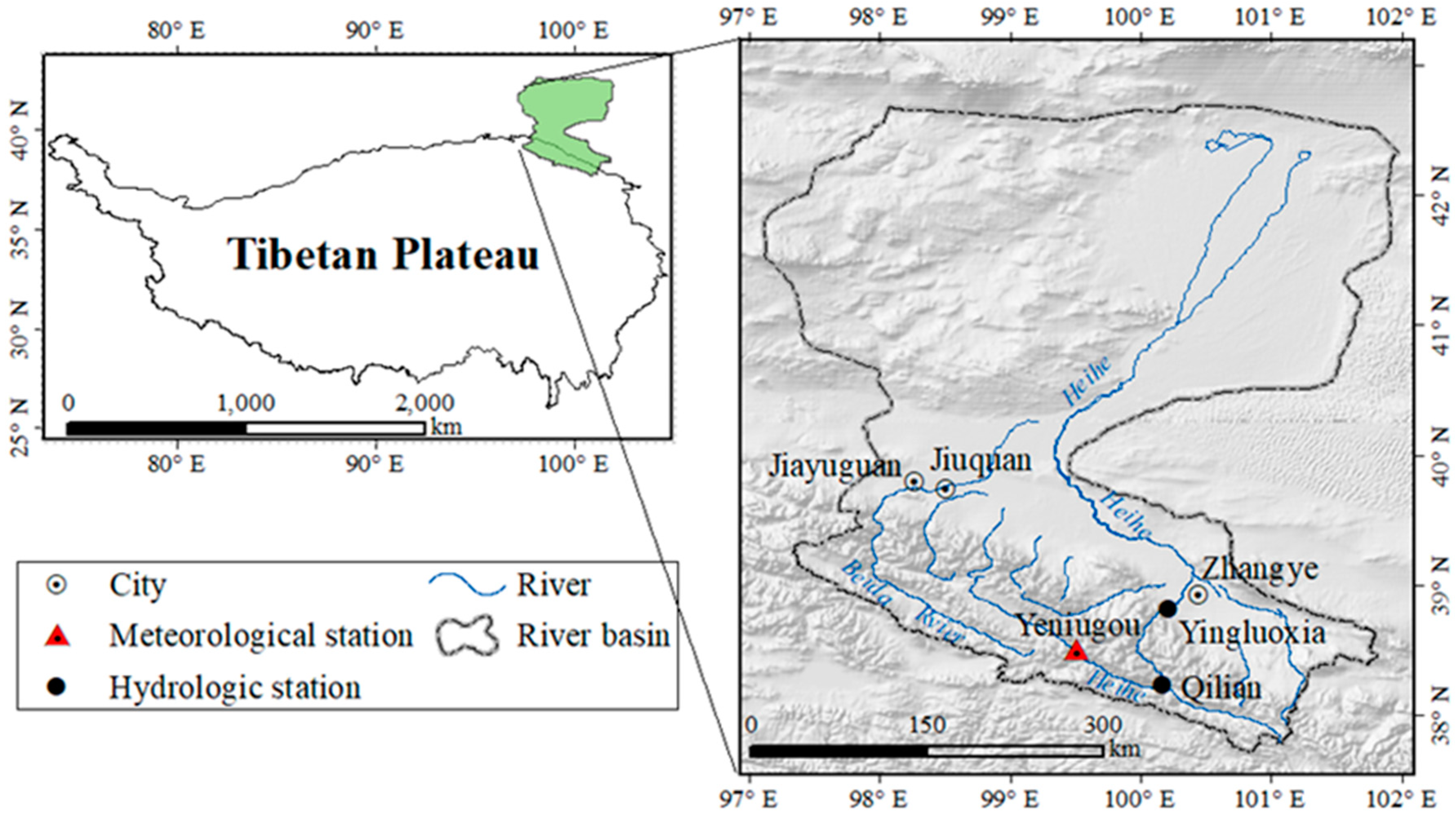
2. Study Area and Precipitation Sampling

2.1. Site Description

The Qilian Mountains, mainly dominated by a series of parallel NWW ridges and valleys, are located in the Northern Tibetan Plateau and their slopes dip to the south and north [20,21]. The study region was located in the middle of the Qilian mountains within an elevation range of 1600 to 5100 m a.s.l. (above sea level), see Figure 1. Steep valleys have dense vegetation cover in the study area, rain falls copiously, and annual precipitation amounts exceed 200 mm and can even exceed 600 mm in some alpine regions [22,23,24]. The Qilian Mountains are the water source area for the Heihe River Basin, the second largest inland river basin in China. In the Heihe River Basin, the proportion of precipitation to the mountainous runoff was estimated to be 90% [25]. The precipitation in the Qilian Mountains makes up the majority of the water available for irrigation and municipal water supplies, providing water for over 1.5 million people living in the middle and lower reaches. The study of hydrological processes in this region has important significance for science and society [26,27].

2.2. Precipitation Sampling

Three sampling sites were established along the main Heihe River, see Figure 1. One site was the Yeniugou meteorological station (3320 m a.s.l.), which is located within the source area of the Heihe River. The other two sites were located at the Qilian hydrological stations (2787 m a.s.l.) and Yingluoxia hydrological station (1674 m a.s.l), which is the dividing point between the upper and middle reaches of the Heihe River Basin. The spatial range of the sampling locations covers the upper reaches of the Heihe River Basin.
Since the error from the sampling process is greater than the error from the sample analysis [28], a detailed sampling procedure was established. Precipitation samples were collected for each precipitation event at the three stations between 2007.10 and 2009.9. The air temperature and humidity at the beginning and end of the precipitation event were recorded, as well as the total rainfall. When the rain cleared, the samples were packed in 30 mL PET (Polyethylene terephthalate) plastic bottles to be protected from evaporation.
The Yeniugou meteorological station samples between 2008.10 and 2009.9 were omitted, so the precipitation δ18O-elevation gradient discussion focuses only on isotopic data collected from 2007.10 to 2008.9 (one full year). Isotopic measurements were completed at the State Key Laboratory of Cryospheric Sciences, Chinese Academy of Sciences. Water isotope (δD, δ18O) values were measured via a Picarro liquid-water isotope analyzer, with accuracies of 0.5 ‰ for δD and 0.025‰ for δ18O. All of the isotope values are expressed in per mil notation (‰) relative to the Vienna standard mean ocean water (VSMOW). The precipitation-weighted annual and season mean δ18O was calculated using Equation (1):
δ 18 O w e i g h t e d = 1 n d i · p i 1 n p i
where di is each precipitation event’s δ18O value, pi is the precipitation amount for that individual event, and n is the number of the precipitation events during the observation period.

3. Results

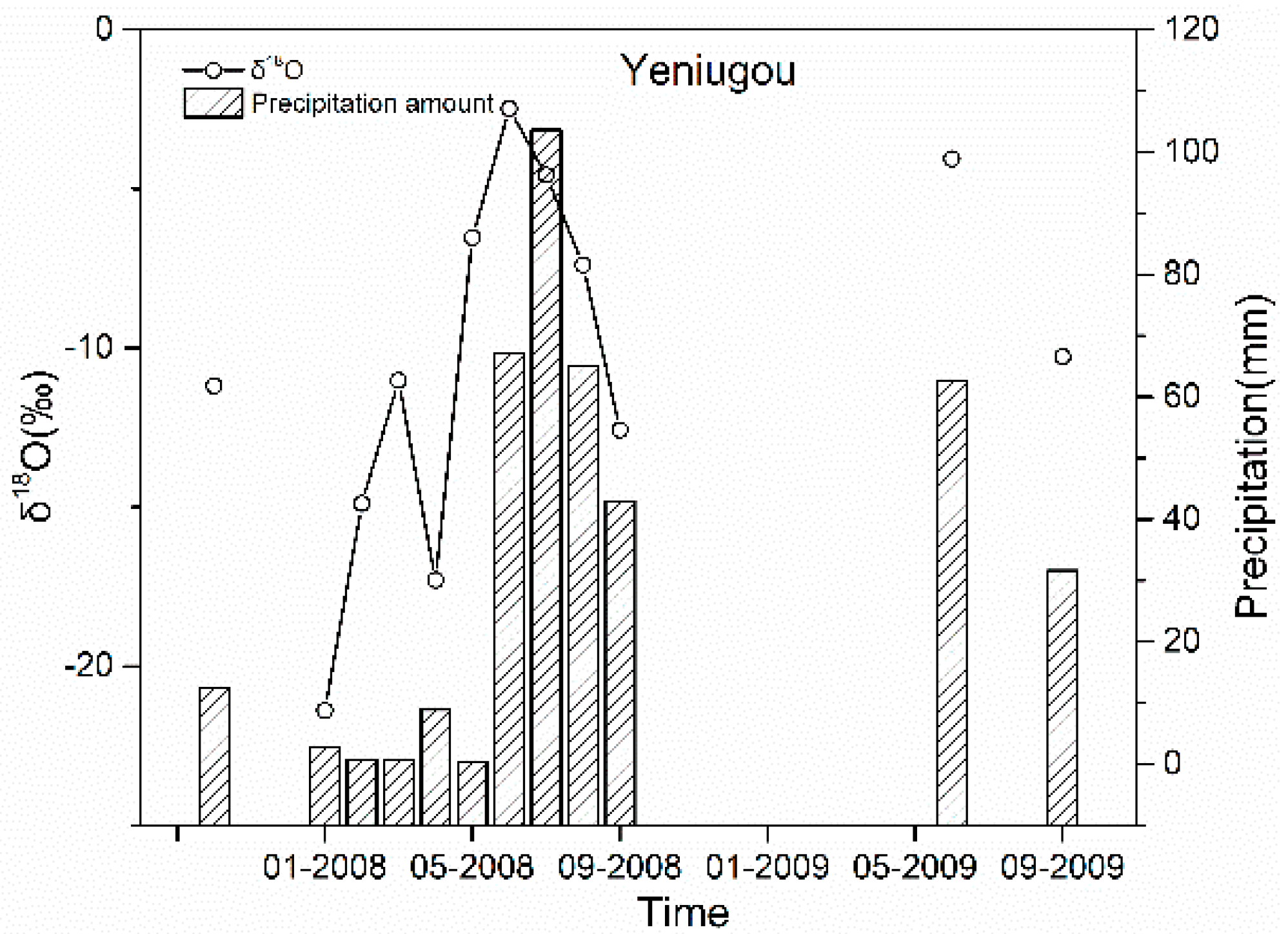
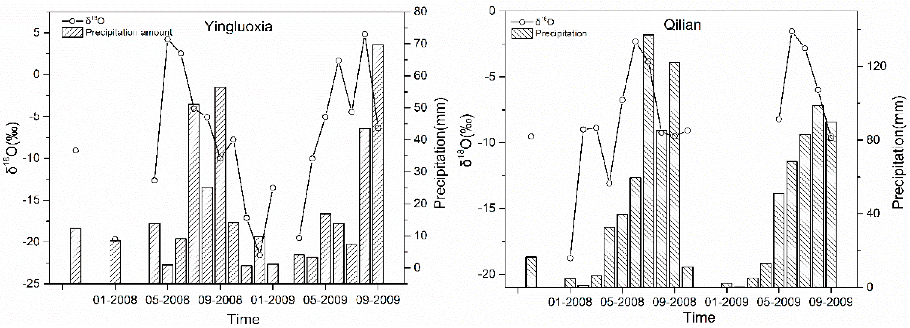
3.1. The Seasonal Variation of Precipitation δ18O

During the observing period (2007.10–2008.9), 58 precipitation samples were collected from the Yeniugou meteorological station and precipitation δ18O values ranged from −25.5‰–2.8‰ with an arithmetic mean of −9.1‰ and a precipitation-weighted mean δ18O of −6.7‰. The number of samples collected from the Qilian hydrological station was 103 and these had a δ18O value range of −21.8–4.7‰, an arithmetic mean of −7.4‰, and a precipitation-weighted mean of −7.2‰. For the Yingluoxia hydrological station, 49 precipitation samples were collected, and the δ18O values ranged from −25.9–6.0‰, with an arithmetic mean of −6.8‰ and a precipitation-weighted mean of −7.5‰.
Most annual precipitation fell during the warm season (2008.5–2008.9) in this region, as shown in Figure 2. The proportion of cold season precipitation (2007.10–2008.4) relative to the annual precipitation (2007.10–2008.9) was 21% at the Yingluoxia hydrological station, 12% at the Qilian hydrological station, and 11% at the Yeniugou meteorological station. Winter precipitation was much lower than summer precipitation. This result is similar to those of previous studies [15,16,17,29,30].

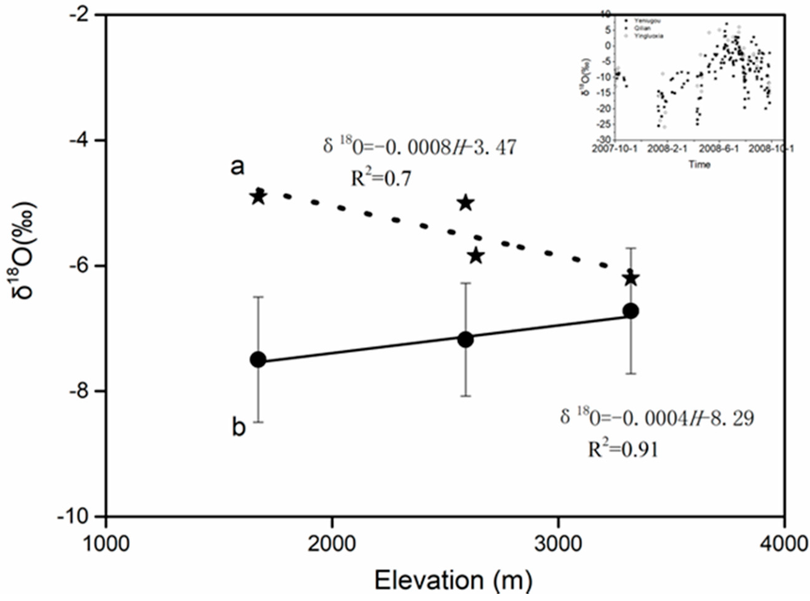
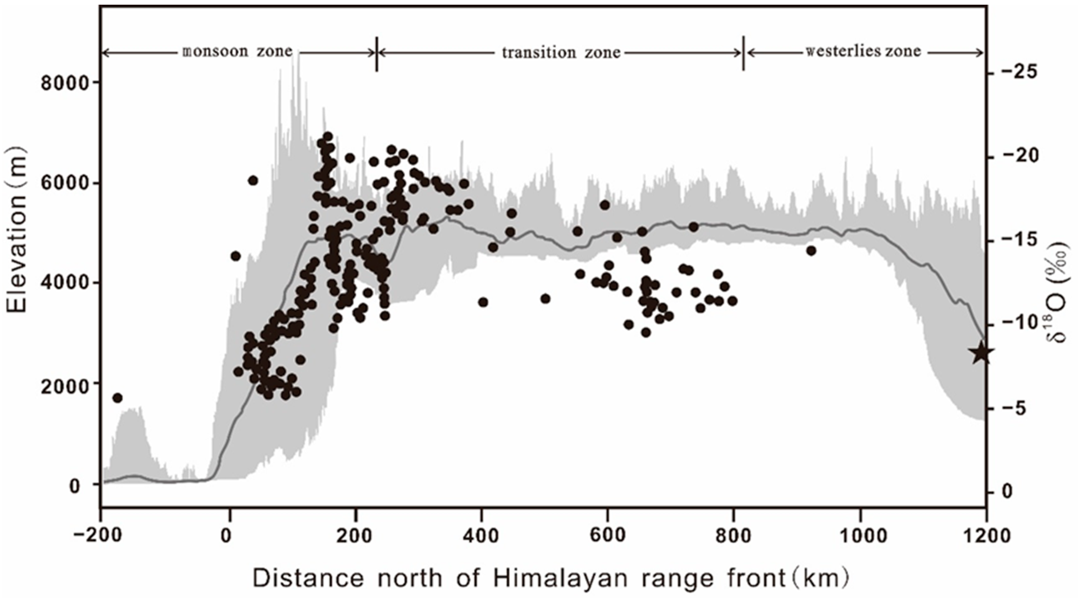
3.2. The Precipitation δ18O-Elevation Gradient

The altitude span between the Yeniugou meteorological station and the Yingluoxia hydrological station is 1600 m. That showed that the change of annual mean values of δ18O in precipitation between the three stations was very small, see Figure 3. The difference between the maximum and minimum annual mean values was only 0.8‰, and the precipitation δ18O-elevation gradient was −0.04‰/100 m, see Figure 3b. Analyses of previous data on the isotopic content change in precipitation revealed a similar result, see Figure 3a [15]. During 2006.5–2007.5, the difference between the maximum annual mean and the minimum annual mean of precipitation δ18O was only 1.3‰ at four stations (Yingluoxia, Qilian, Zhamashi hydrological station, and Yeniugou meteorological station). Precipitation-weighted mean δ18O values hardly changed with elevation and the precipitation δ18O-elevation gradient was only −0.07‰/100 m. Zhang Yinghua et al. [16] measured the precipitation-weighted mean δ18O in precipitation collected from fourteen sites in the upper reaches of the Heihe River Basin in the Qilian Mountains and they found a relationship between δ18O in precipitation and elevation that they described by δ18O = −0.0018H−1.6891 (R2 = 0.22). Although the simple linear relationship indicated that the δ18O-elevation gradient was −0.18‰/100m, the regressions between precipitation-weighted mean δ18O and elevation showed a weak correlation with an R2 value of 0.22.
We found that the results of this study were only one-seventh to one-fourth of the δ18O-elevation gradients in other regions of the Tibetan plateau. For example, on the southern slope of the Himalayas, the average yearly precipitation-weighted mean δ18O-elevation gradient was measured to be −0.15‰/100 m [10] and the δ18O-elevation gradient was measured to be −0.3‰/100 m in the Southern Tibetan plateau and surrounding area [31]. Our study was smaller than the global average of δ18O-elevation gradients (−0.28‰/100 m), and exceeded the range of the global precipitation δ18O–elevation gradients (−0.10–−1.1‰/100 m [8]).
These results point to precipitation δ18O-elevation gradients being smaller in the Qilian Mountains. To assess whether or not the elevation variation has a significant influence on the δ18O of precipitation in the region, statistical analyses were performed by analysis of variance (ANOVA). ANOVA assesses whether or not the variation of a control variable has a significant influence on the observation variability though variance of an observation variability. We regarded the isotopic value of a single precipitation event as a sample element. The sample space was the set of all of the precipitation δ18O data for each of the three stations during the observation period (2007.10–2008.9). The sample capacities for the stations were 58 (n1 = 58) for the Yeniugou meteorological station, 103 (n2 = 103) for the Qilian hydrological station, and 49 (n3 = 49) for the Yingluoxia hydrological station. Data were analyzed by one-way ANOVA with SPSS 20(IBM), see Table 1 and Table 2. Two hypotheses were established: The null hypothesis (H0), stated that the three population means were all the same, and the alternative hypothesis (H1), stated that the three population means were not the same or not all. An alpha level of 0.05 was used and, from the ANOVA report, F = 1.861 and P = 0.158 > α = 0.05. As a result, the null hypothesis (H0) was accepted. ANOVA revealed that the differences in the annual mean precipitation δ18O among the three points were not significant at a significance level of 5%. In other words, there was no significant correlation between elevation and annual mean precipitation δ18O in this study region.
More rainfall occurs during the warm season in the case study area. The rainfall-weighted means δ18O of the three sites during the warm and cold seasons from 2007.10 to 2008.9 are given in Figure 4. As shown in Figure 4, the linear correlation showed a low determination coefficient (warm season R2 = 0.02, cold season R2 = 0.05) between elevation, the mean values of precipitation δ18O in the warm and cold season are weak, and the precipitation δ18O-elevation gradient was very close to 0.00‰. The result of ANOVA showed that there was a small difference between the δ18O mean values of these three stations in the warm and cold season, which amounted to no significant altitude effect. This result agrees with the analysis of the relationship between the annual precipitation δ18O mean values and elevation. In short, both at the annual and seasonal scale, the results showed that the altitude effect of δ18O in precipitation was not significant in this region.

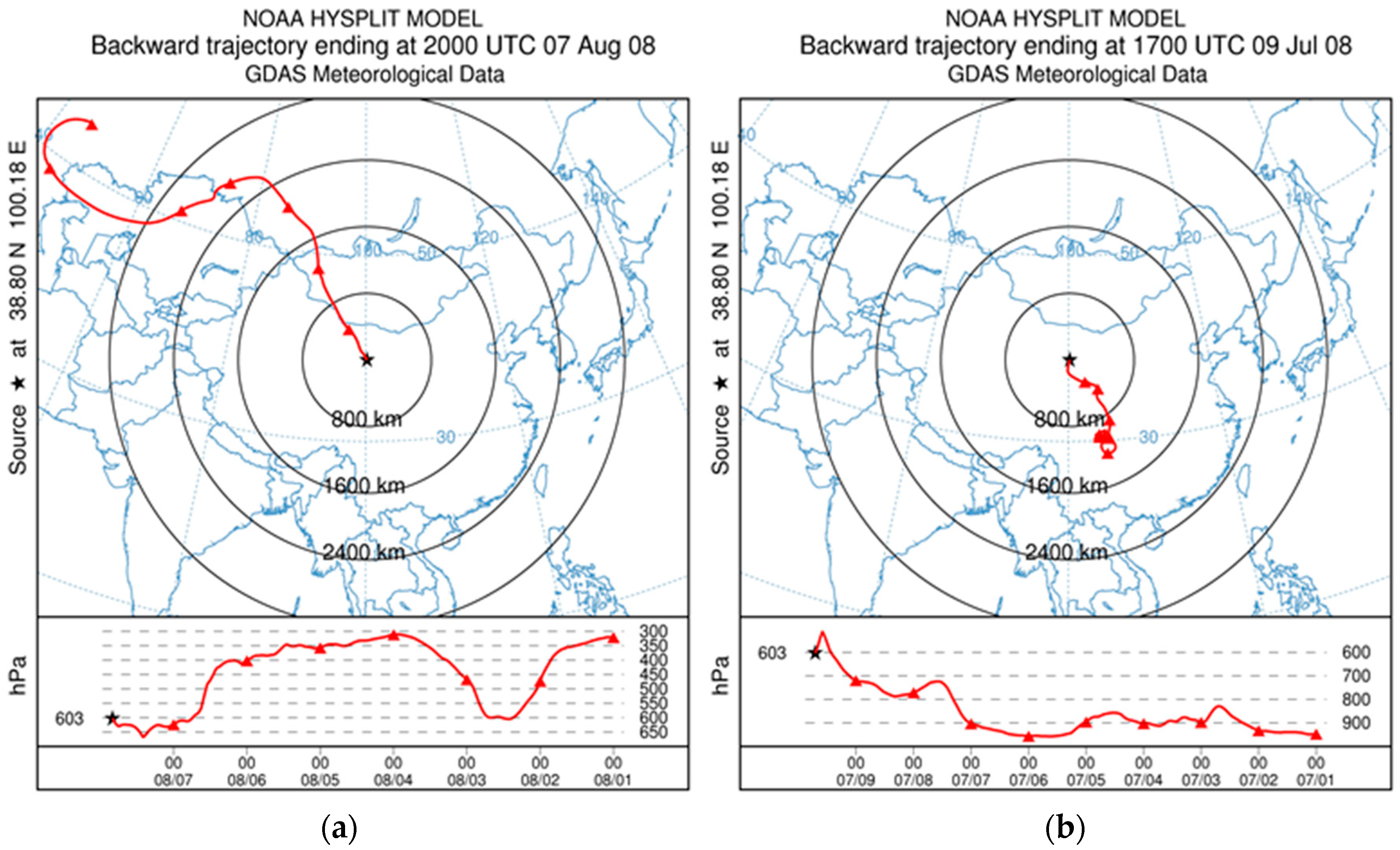
3.3. Trajectory Analysis of the Atmospheric Water Vapor

Atmospheric water vapor is the material basis of precipitation, and the source and evolutionary process is reflected by the variation of precipitation δ18O. A NOAA Hysplit Trajectory Model was run for a 10-day backward trajectory analysis of individual precipitation events at three stations (Yeniugou, Qilian, and Yingluoxia) in the period from 2007.10 to 2008.9 to determine the origin of air masses, see Figure 5. The backward trajectory starting height was set to 2000 m above the ground, where the maximum moisture flux occurs [32]. Statistical analysis of the proportion of precipitation condensed by different moisture sources in the annual precipitation was calculated using the following equation:
k = p P
where ∑p is the sum of the precipitation amounts at the individual stations that were condensed by the same source of moisture. Moisture likely came from the west, north, or northwest if transported by the westerly belt, and from the east, south, or southeast if transported by monsoons. ∑P is the sum of the total precipitation at the individual stations during the period from 2007.10 to 2008.9.
The simulation results showed that precipitation during the year at the three sites was mainly derived from westerly sources, though monsoon sources also contributed. The proportion of westerly precipitation relative to the total precipitation from 2007.10 to 2008.9 was 62.5% at Yingluoxia Station, 79.5% at Yeniugou Station, and 89.1% at Qilian Station, see Table 3.
Using the Hysplit Trajectory Model, air mass trajectories were simulated for each season from 2007.12 to 2008.11 above the Yingluoxia station. The results showed that almost all air masses came from the west or northwest during spring, autumn, and winter and that air masses were transported by monsoon during the summer with 9% of the air masses coming from the east, and 91% coming from the west. In short, the westerly belt appeared to be responsible for the transport of most water vapor in the region, in agreement with previous studies [17,29,30,31,33]. We did not distinguish the local water vapor from transported water vapor during the simulation. Instead, the source of water vapor was simply divided between the westerly belt or monsoon based on source assessment. The proportion of rainfall formed by local water vapor in the annual precipitation in the region has been studied in more depth.

4. Discussion

The isotopic composition of precipitation tends to change with the altitude of the terrain and becomes more and more depleted in δ18O and δD at higher elevations. This altitude effect of precipitation isotopic composition is best described by an ideal Rayleigh law in an open system. Condensation of rain is a phase separation process in an open system. As rain condenses, the heavier isotopes of water are preferentially removed from the air mass, and the air mass consequently becomes progressively lighter in isotopic composition along the moisture trajectory. The altitude effect on the stable isotope composition in modern precipitation also displays regional variations [8].
Djebou et al. [34] investigated the potential interactions between watershed characteristics and precipitation variability and the magnitude of watersheds’ effects on precipitation was assessed. Their results show the necessity to include watershed topography in global and regional climate model parameterizations. This altitude effect is caused by increased rain at higher elevations due to continuous cooling of the air mass pseudo-adiabatically to below the dew point in an orographic precipitation system [35]. As the air mass rises along the slope, the continuous rainout process creates residual water vapor at higher elevations that is increasingly depleted in the heavy isotopic species due to preferential partitioning of the heavy isotopic species into the liquid phase relative to the vapor phase. In addition, the rise of moisture results in a decreased temperature of condensation, which further increases the fractionation between the liquid and vapor phases. Thus, the altitude effect is caused by both the evolution of the parent, condensing water vapor and the temperature of condensation. The elevation of water vapor along the slope is a driving factor of the altitude effect; therefore, the altitude effect on the windward slope is more significant than on the orographic slope, and the source of water vapor at the place where the altitude effect is significant is also relatively single.
The south side of the Himalayas is mainly under the Indian monsoon. The Himalayas act as the orographic barrier and first-order control on the regional precipitation patterns. Thus, as water vapor transported by the Indian monsoon rises along the south side of the Himalayas, both rainout and fractionation result in depletion in precipitation δ18O, and the δ18O-elevation gradient is −0.15‰/100 m [10]. In the orographic rain shadow of the Himalayas and the interior plateau, δ18O-elevation relationships are less straightforward [1,36]. Lechler et al. [1] observed that the δ18O-elevation gradient (-0.08‰/100 m) of the orographic rain shadow on the eastern side of the Sierra Nevada was two to three times lower than that of the orographic slope on the western side (−0.2‰/100 m). This climate was mainly controlled by the westerly belt in the Heihe River Basin. The Qilian Mountains’ axis strikes essentially east–west and is mainly composed of a series of parallel mountains and wide valleys extending in the NWW direction. The dip direction of the slope is mainly to the north or south. The migration path of the westerly winds is almost parallel to the trend of the Qilian Mountains. Moving from west to east, the water vapor transported by the westerly wind lacks the dynamic process of climbing along the slope, which results in an insignificant precipitation δ18O-elevation gradient despite the large elevation change.
In addition to topographical factors affecting the evolution of stable isotopes in precipitation, water vapor serves as the material basis for precipitation, and its source and evolution also affect the variation of stable isotopes in precipitation. Mechanisms that have been proposed to explain regional variability in δ18O-elevation gradients primarily consider the role of atmospheric processes, including (1) mixing of moisture sources, a common process in continental interiors, (2) the role of convective storms and their associated violation of Rayleigh distillation processes in open systems, (3) the re-evaporation and recycling of 18O-enriched continental waters, and (4) the “amount effect,” which accounts for drop–size–dependent isotopic equilibration times [1]. Each of these processes may act to produce precipitation δ18O-elevation gradients that differ from those predicted by a simple Rayleigh distillation rainout and produce an increase in the regional changes in precipitation δ18O-elevation gradients. Since the Heihe River Basin is located in an inland arid area of Northwest China, mixing of moisture sources, re-evaporation, and recycling of δ18O-enriched continental waters, and evaporative enrichment in the falling droplets beneath the cloud base are very dynamic. This results in an insignificant relationship between precipitation δ18O values and elevation.
According to the atmospheric circulation around the Tibetan Plateau, the Tibetan Plateau is divided into three zones: the monsoon zone, the transition zone, and the westerlies zone [31]. The monsoon zone is generally located south of 30° N, the transitional zone is located between 35° and 30° N, the westerlies zone is located north of 35° N, and the headwaters of the Heihe River are located in the westerlies zone of the Tibetan Plateau, as shown in Figure 6. In the Indian monsoon-dominated zone, water vapor transported by the Indian monsoons is blocked by the orographic barrier, forming orographic precipitation on the south slope of the Himalayas (the windward slope). The precipitation process follows the Rayleigh fractionation process of a single water vapor source; therefore, the precipitation δ18O-elevation gradients in this region are significant. There was a well-defined relationship between δ18O and elevation along the orographic slope (−0.15‰/100 m [1,10]). As the distance from the Himalayan front increased, δ18O-elevation relationships were less straightforward in the transitional zone due to the influence of water vapor from different sources.
In the westerly zone, the headwater regions of the Heihe River in the Qilian Mountains are located far from the Himalayan front, and a disconnect between δ18O and elevation was observed. In short, the precipitation δ18O-elevation gradient over the Tibetan Plateau showed a gradual decrease from south to north. The precipitation δ18O-elevation gradient in the Qilian Mountains in the northern margin of the Tibetan Plateau was almost zero, as shown in Figure 6.

5. Conclusions

This study demonstrated that the altitude effect in precipitation δ18O between 1600–3300 m does not appear to be significant in the Qilian Mountains, and the precipitation-weighted annual mean δ18O was measured to be −7.1‰. This was the result of the combined action of water vapor from different sources and orographic factors. This indicated that the spatial relationship between the geographic orientation of mountains and the main water vapor transport trajectory are important factors affecting stable isotope characteristics in precipitation. The results of this study are significant for the accuracy of estimating the paleoelevation of the Tibetan Plateau, and also indicate that the judgment of the formation area of water resources and groundwater recharge height in the Heihe River Basin based on the δ18O-elevation gradients in modern precipitation may need to be reconsidered.

Author Contributions

J.H. designed the study, analyzed the results and wrote the manuscript; W.Z. and Y.W. made editing corrections and improvements to the manuscript.

Funding

This research was funded by the National Natural Science Foundation of China (grant nos. 41871053 and 41690144), the Geological Investigation Project of the Chinese Geological Survey (grant nos. DD20160060) and the Chinese Academy of Sciences (CAS) ‘Light of West China’ Program.

Acknowledgments

Special thanks are given to anonymous reviewers for very helpful suggestions. Our thanks are also given to all those involved with precipitation sample collections.

Conflicts of Interest

The authors declare no conflict of interest.

References

  1. Lechler, A.R.; Niemi, N.A. The influence of snow sublimation on the isotopic composition of spring and surface waters in the southwestern united states: Implications for stable isotope-based paleoaltimetry and hydrologic studies. Geol. Soc. Am. Bull. 2012, 124, 318–334. [Google Scholar] [CrossRef]
  2. Rowley, D.B.; Currie, B.S. Palaeo-altimetry of the late eocene to miocene lunpola basin, central tibet. Nature 2006, 439, 677–681. [Google Scholar] [CrossRef] [PubMed]
  3. Poage, M.A.; Chamberlain, C.P. Empirical relationships between elevation and the stable isotope composition of precipitation and surface waters: Considerations for studies of paleoelevation change. Am. J. Sci. 2001, 301, 1–15. [Google Scholar] [CrossRef]
  4. Cyr, A.J.; Currie, B.S.; Rowley, D.B. Geochemical evaluation of fenghuoshan group lacustrine carbonates, north-central tibet: Implications for the paleoaltimetry of the eocene tibetan plateau. J. Geol. 2005, 113, 517–533. [Google Scholar] [CrossRef]
  5. Rowley, D.B.; Pierrehumbert, R.T.; Currie, B.S. A new approach to stable isotope-based paleoaltimetry: Implications for paleoaltimetry and paleohypsometry of the high himalaya since the late miocene. Earth Planet. Sci. Lett. 2001, 188, 253–268. [Google Scholar] [CrossRef]
  6. DeCelles, P.G.; Quade, J.; Kapp, P.; Fan, M.; Dettman, D.L.; Ding, L. High and dry in central tibet during the late oligocene. Earth Planet. Sci. Lett. 2007, 253, 389–401. [Google Scholar] [CrossRef]
  7. Quade, J.; Breecker, D.O.; Daeron, M.; Eiler, J. The paleoaltimetry of tibet: An isotopic perspective. Am. J. Sci. 2011, 311, 77–115. [Google Scholar] [CrossRef]
  8. Clark, I.; Fritz, P. Environmental Isotopes in Hydrogeology; Lewis: New York, NY, USA, 1997. [Google Scholar]
  9. Chen, J.S.; Wang, J.Y.; Zhao, X.; Shen, X.f.; Gu, W.Z.; Chen, L.; Su, Z.G. Study of groundwater supply of the confined cquifers in the ejin basin based on isotopic methods. Geol. Rev. 2004, 6, 649–658. [Google Scholar]
  10. Wen, R.; Tian, L.D.; Wong, Y.B.; Liu, Z.F.; Zhao, Z.P. The altitide effect of δ18o in precipitation and river water in the southern himalayas. Chin. Sci. Bull. 2012, 57, 1053–1059. [Google Scholar] [CrossRef]
  11. Yang, X.X.; Xu, B.Q.; Yang, W.; Qu, D.M.; Lin, P.N. The indian monsoonal influence on altitude effect of δ18o in surface water on southeast tibetan plateau. Sci. China Earth Sci. 2012, 42, 747–754. [Google Scholar]
  12. Ding, L.; Xu, Q.; Zhang, L.Y.; Yang, D.; Lai, Q.Z.; Huang, F.X.; Shi, R.D. Regional variation of river water oxygen isotope and empirical elevation prediction models in Tibetan plateau. Quat. Sci. 2009, 29, 1–12. [Google Scholar]
  13. Chen, Z.Y.; Wan, L.; Nie, Z.L.; Shen, J.M.; Chen, J.S. Idetification of groundwater recharge in the heihe basin using environmental isotopes. Hydrogeol. Eng. Geol. 2006, 6, 9–14. [Google Scholar]
  14. Nie, Z.L.; Chen, Z.Y.; Shen, J.M.; Zhang, G.H.; Cheng, X.X. Environmental isotopes as tracers of hydrological cycle in the recharge area of the heihe river. Geogr. Geo-Inf. Sci. 2005, 21, 104–108. [Google Scholar]
  15. Wang, N.L.; Zhang, S.B.; He, J.Q.; Pu, J.C.; Wu, X.B.; Jiang, X. Tracing the major source area if the mountainous runoff generation of the heihe river in northwest ching using stable isotope technique. Chin. Sci. Bull. 2009, 54, 2148–2152. [Google Scholar] [CrossRef]
  16. Zhang, Y.H.; Wu, Y.Q. Characteristics of the δ18o in precipitation in theupper and middle reaches of heihe river. J. Glaciol. Geocryol. 2007, 29, 440–445. [Google Scholar]
  17. Zhao, L.J.; Yin, L.; Xiao, H.L.; Cheng, G.D.; Zhou, M.X.; Yang, Y.G.; Li, C.Z.; Zhou, J. Isotopic evidence for the moisture origin and composition of surface runoff in the headwaters of the heihe river basin. Chin. Sci. Bull. 2011, 56, 58–67. [Google Scholar] [CrossRef]
  18. Wang, N.L.; Zhang, S.B.; Pu, J.C.; He, J.Q.; Jiang, X.; Wu, X.B. Seasonal variation of δ18o in river water in the upper reaches of heihe river basin and its influence factors. J. Glaciol. Geocryol. 2008, 30, 914–920. [Google Scholar]
  19. Zhang, Y.H.; Wu, Y.Q. Variation of δ18o in water in heihe river basin. Adv. Water Sci. 2007, 18, 864–870. [Google Scholar]
  20. Cai, H.W. The neoteetonics in the qilian montainsregion. Northwest. Geol. 1984, 4, 25–28. [Google Scholar]
  21. Hu, X.F.; Pan, B.T.; EIRBY, K.; Li, Q.Y.; Geng, H.P.; Chen, J.F. Spatial differences in rock uplift rates inferred from channel steepness indices along the northern flank of qikian mountain, northeast. Chin. Sci. Bull. 2010, 55, 2329–2338. [Google Scholar] [CrossRef]
  22. Yi, X.Z.; Zhang, Q.; Xu, Q.Y.; Xue, W.X.; Guo, H.; Shi, Z.J. Characteristics of climate change in qilian mountains region in recent 50 years. Plateau Meteorol. 2009, 28, 85–90. [Google Scholar]
  23. Zhang, L.; Zhang, Q.; Feng, J.Y.; Bai, H.Z.; Zhao, J.H.; Xu, X.H. A study of atmospheric water cycle over the qilian mountains(i): Variation of annual water vapor transport. J. Glaciol. Geocryol. 2014, 36, 1079–1091. [Google Scholar]
  24. Li, Z.; Gao, Y.; Wang, Y.; Pan, Y.; Li, J.; Chen, A.; Wang, T.; Han, C.; Song, Y.; Theakstone, W.H. Can monsoon moisture arrive in the qilian mountains in summer? Quat. Int. 2015, 358, 113–125. [Google Scholar]
  25. He, J.Q.; Song, G.J.; Jiang, X.; Li, Q.L.; Wu, X.B. Relation between glacial meltwater runoff and mountainous runoff in 2006 in four typical river basins of heihe river water system. J. Desert Res. 2008, 28, 1186–1189. [Google Scholar]
  26. Wang, W.H.; Zou, S.B.; Xiao, H.L.; Yi, Z.L.; Lu, Z.X.; Liu, S.Y. Eco-hydrological ontology in inland river basin: Construction method and application. J. Glaciol. Geocryol. 2014, 36, 1280–1287. [Google Scholar]
  27. Yang, Y.; Yang, J.P.; Li, M.; Tong, C.P.; Wang, S.X.; Wang, S.J. Public perception and selections of adaptation measures against glacier change and its impacts: Taking the hexi inland river basin as an example. J. Glaciol. Geocryol. 2015, 37, 70–79. [Google Scholar]
  28. Gu, W.Z. Isotope Hydrology; Science Press: Beijing, China, 2011. [Google Scholar]
  29. Zhou, S.Q.; Nakawom, S.; Keqin, D.; Jianchen, P. Water isotope variations in the snow pack and summer precipitation at july 1 glacier, qilian mountains in Northwest China. Chin. Sci. Bull. 2007, 52, 2187–2193. [Google Scholar] [CrossRef]
  30. Ding, Y.J.; Ye, B.S.; Zhou, W.J. Temporal and spatial precipitation distribution in the heihe catchment, northwest china, during the past 40 a. J. Glaciol. Geocryol. 1999, 21, 42–48. [Google Scholar]
  31. Yao, T.D.; Zhou, X.; Yang, X.X. Indian monsoon influences altitude effect of δ18o in precipitation/river water on the tibetan plateau. Chin. Sci. Bull. 2009, 54, 2124–2130. [Google Scholar] [CrossRef]
  32. Zhang, X.W. Vertical distribution of the transported quantity of material and energy by airflow. Desert Oasis Meteorol. 2009, 3, 1–5. [Google Scholar]
  33. Wang, K.L.; Jiang, H.; Zhao, H.Y. Atmospheric water vapor transport from westerly and monsoon over the Northwest China. Adv. Water Sci. 2005, 16, 432–438. [Google Scholar]
  34. Djebou, D.C.S.; Singh, V.P.; Frauenfeld, O.W. Analysis of watershed topography effects on summer precipitation variability in the southwestern united states. J. Hydrol. 2014, 511, 838–849. [Google Scholar] [CrossRef]
  35. Kendall, C.; McDonnell, J.J. Isotope Tracers in Catchment Hydrology; Elsevier Science: Amsterdam, The Netherlands, 1998. [Google Scholar]
  36. Yao, T.D.; Masson-Delmotte, V.; Gao, J.; Yu, W.S.; Yang, X.X.; Risi, C.; Sturm, C.; Werner, M.; Zhao, H.B.; He, Y.Q.; et al. A review of climatic controls on δ18o in precipitation over the tibetan plateau: Observations and simulations. Rev. Geophys. 2013. [Google Scholar] [CrossRef] [Green Version]
Figure 1. The Heihe River Basin and sampling site locations.
Water 10 01797 g001
Figure 2. Time series of precipitation and δ18O ratio of rainfall (2007.10–2009.9).
Water 10 01797 g002aWater 10 01797 g002b
Figure 3. The δ18O variability with elevation during sampling between 2007.10 and 2008.9 in the upper reaches of the Heihe River Basin in the Qilian Mountains. Error bars represent the relative standard deviation (RSD). The inset shows the δ18O values for individual precipitation events in the three sampling sites. a: 2006.5–2007.5 (from Ninglian Wang et al. [18]); b: 2007.10–2008.9 (this study).
Water 10 01797 g003
Figure 4. The δ18O variability with elevation in the warm and cold seasons from 2007.10 to 2008.9 in the upper reaches of the Heihe River Basin. Error bars represent relative standard deviation (RSD). a: warm season (2008.5–2008.9); b: cold season (2007.10–2008.4).
Water 10 01797 g004
Figure 5. Two typical cases of air mass back trajectories of individual precipitation events by the Hysplit model for (a) 2008.8.7 at Yingluoxia station and (b) 2008.6.9 at Yingluoxia station.
Water 10 01797 g005
Figure 6. Topographic swath profiles (left y-axis) and meteoric water δ18O values (right y-axis) plotted as a function of distance from the major regional orographic barrier for the Himalayan–Tibetan Plateau orogen. Upper and lower bounds of the gray swath mark the maximum and minimum elevations, respectively. Dark-gray lines mark mean elevation. Solid circles indicate δ18O values, the star indicates the precipitation-weighted annual mean δ18O in the upper reaches of the Heihe River Basin (compiled from Lechler et al. [1]).
Water 10 01797 g006
Table 1. Test of homogeneity of variance.
Levene Statisticdf1df2Sig.
1.04222070.354
df1 = degrees of freedom between groups; df2= degrees of freedom within groups; Sig. = significance.
Table 2. One-way analysis of variance (ANOVA).
Sum of SquaresdfMean SquareFSig.
Between Groups171.397285.6981.8610.158
Within Groups9533.46820746.055
Total9704.865209
df = degrees of freedom; F = F-test statistic; Sig. = significance.
Table 3. Analysis of precipitation from different water vapor sources in the upper reaches of the Heihe River Basin from 2007.10 to 2008.9. The number of precipitation samples from different sources for each site is given in the column labeled “n”.
Source of MoistureYingluoxiaQilianYeniugou
nProportion in Total Rainfall during the Period (%)nProportion in Total Rainfall during the Period (%)nProportion in Total Rainfall during the Period (%)
Westerly belt 3762.57189.14179.5
Monsoon1237.53210.91620.5
Total4910010310057100
Due to the possibility of undersampling during the sampling process, the statistical value of precipitation should be smaller than the actual value.

