Achieving Urban Flood Resilience in an Uncertain Future
by
 , , , and
Richard Fenner
1,*, 
Emily O’Donnell
2,
Sangaralingam Ahilan
3,
David Dawson
4,
Leon Kapetas
1,
Vladimir Krivtsov
5,
Sikhululekile Ncube
5 and
Kim Vercruysse
4 1
Department of Engineering, University of Cambridge, Cambridge CB2 1PZ, UK
2
School of Geography, University of Nottingham, Nottingham NG7 2RD, UK
3
Centre for Water Systems, College of Engineering, Mathematics and Physical Sciences, University of Exeter, Exeter EX4 4QF, UK
4
Faculty of Engineering, University of Leeds, Leeds LS2 9JT, UK
5
School of Energy, Geoscience, Infrastructure and Society, Heriot-Watt University, Edinburgh EH14 4AS, UK
*
Author to whom correspondence should be addressed.
Water 2019, 11(5), 1082; https://doi.org/10.3390/w11051082
Submission received: 26 April 2019
/
Revised: 21 May 2019
/
Accepted: 22 May 2019
/
Published: 24 May 2019
(This article belongs to the Special Issue Flood Risk and Resilience)
Abstract
:Preliminary results of the UK Urban Flood Resilience research consortium are presented and discussed, with the work being conducted against a background of future uncertainties with respect to changing climate and increasing urbanization. Adopting a whole systems approach, key themes include developing adaptive approaches for flexible engineering design of coupled grey and blue-green flood management assets; exploiting the resource potential of urban stormwater through rainwater harvesting, urban metabolism modelling and interoperability; and investigating the interactions between planners, developers, engineers and communities at multiple scales in managing flood risk. The work is producing new modelling tools and an extensive evidence base to support the case for multifunctional infrastructure that delivers multiple, environmental, societal and economic benefits, while enhancing urban flood resilience by bringing stormwater management and green infrastructure together.
1. Introduction
Achieving Urban Flood Resilience requires solving a number of interrelated engineering, environmental and socio-political challenges to achieve the transformative change needed in urban stormwater and flood risk management. This will involve dealing with the future uncertainties associated with extreme weather events driven by global warming, and the consequences of increasingly rapid urbanisation. Recognising these constraints, new approaches are urgently needed, which are based on adaptive and flexible designs of a range of traditional grey infrastructure (e.g., underground pipes, detention tanks and lined drainage channels) and innovative blue-green solutions (e.g., swales, rain gardens, wetlands, green roofs and restored urban streams). In moving towards source control techniques which provide infiltration, attenuation and storage that mimic the predevelopment hydrology of an area, the paradigm of urban flood management can be switched from threat to opportunity. This emphasises the resource potential of urban stormwater (for example for water supply and energy generation), as part of a wider “system of systems” of urban infrastructure which can be managed interoperably. However, to deliver these changes planning and adoption barriers must be overcome and solutions must be embraced by the communities they serve.
The Urban Flood Resilience research project was launched in 2016 and comprises a consortium of nine UK Universities supported by government agencies, engineering consultants and planning authorities responsible for managing urban water and flood risk [1] The aim is to provide the methodologies and tools needed to make transformative change possible through adoption of a whole systems approach to urban flood and water management. This is being done through the development of the next generation of hydrosystems models [2] that bridge the interfaces between urban/rural and engineering/natural hydrological systems. Flexible adaptation pathways are being assessed using a multiple benefits approach [3] to determine the most effective mix of blue-green and grey systems for any given location and time. Capturing the resource potential of stormwater through rainwater harvesting [4] and local energy recovery using micro-hydropower [5] is being examined as part of a multifunctional systems approach to urban flood management [6]. The consortium is also considering the importance of the interfaces between planners, developers, engineers and beneficiary communities by investigating citizen’s interactions with blue-green infrastructure [7]. The results of the research are being applied and demonstrated in a series of case study locations, including Newcastle and Ebbsfleet, supported by effective Learning Action Alliances which are helping translate these findings into practice [8].
2. Preliminary Results
While the work is ongoing this short communication presents a summary of some of the new research outputs not yet reported elsewhere.
2.1. Contribution of Blue-Green Infrastructure to Improving Natural Capital
The impact of future urban intensification on Natural Capital is being investigated by Heriot Watt, Cambridge and Newcastle Universities, focusing on the London Borough of Sutton. Natural Capital refers to the stock of natural features/assets, e.g., freshwater, land, soil, minerals, air, seas, habitats, biodiversity and processes, which together provide the foundation for the flows of ecosystem services [9]. The work is calculating the extent to which blue-green infrastructure systems such as rain gardens, swales and green roofs can mitigate natural resource depletion associated with new development. This is done using the Natural Capital Planning Tool [10] and a geographic information system (GIS) analysis to assess natural capital indicators, such as flood risk regulation, at different spatiotemporal scales.
Research focuses on the residential area of Carshalton, where recent development has led to the existing drainage network reaching its capacity and extreme storm events have caused local flooding incidents. The local authority is planning to mitigate additional flood risk associated with a plan for developing 3000 new homes with new blue-green infrastructure while also providing a ”natural capital uplift”. Two development approaches to stormwater management have been tested consisting of a “grey” pipe-based approach and a blue-green approach including green roofs, rainwater harvesting, rain gardens and street swales. The effectiveness of each approach is assessed using the CityCat hydrodynamics model [2].
The Natural Capital Planning Tool calculates the impact score for 10 selected ecosystem services together with an overall aggregated development impact score. The calculated impact scores are based on a range of indicator data such as population density, soil drainage class, size of green space sites and spatial land use information for the pre- and post development state of an area. Such information is automatically translated into impact scores based on an expert informed quantification model embedded in the Natural Capital Planning Tool. The tool also calculates theoretical minimum and maximum possible scores which show the potential of the site to lose or gain natural capital and associated multiple benefits.
Results show an overall negative development impact score of −17.35 resulting from the introduction of housing infrastructure on green field sites in Carshalton, with air quality and local climate regulation particularly affected. Compared to the theoretical minimum possible score of −21.09, this implies that the “grey” pipe-based approach will result in loss of several multiple benefits as this approach replaces most natural capital in the area. With the introduction of different blue-green approaches based on the adoption of sustainable drainage systems (SuDS) the overall development impact score, although still negative, is significantly reduced to −0.12. This is because some blue-green options such as road swales will enhance natural capital in some parts of the study area while other options such as green roofs will negatively impact on predevelopment land uses which have more potential for multiple benefit delivery compared to the green roofs option. A summary of the nature of the ecosystem service impact scores for each individual blue-green/SuDS intervention on the predevelopment land use are shown in Table 1. All blue-green approaches had a positive impact on aesthetic value and local climate regulation, with swales having the most positive impact overall.
For the blue-green/SuDS interventions hydrodynamic modelling showed an increase in water depth in the swales and a decrease in water depths over the northern part of the area. The interventions in the southern area were found to be less useful as this has less connectivity with the downstream parts of the catchment and the outfalls into the Wandle River. Overall the number of floodable properties was reduced by over 65%. The results highlight the trade-offs and synergies in multiple benefits associated with different combinations of blue-green options. It was found that grey development options increased the flood risk downstream compared to a three times reduction using blue-green options. Overall such Natural Capital assessments can help practitioners, local authorities, planning agencies and developers understand the interdependencies between the natural and urban environments, highlight the different environmental and social benefits that strategies may deliver and provide insight into the relative performance of a range of flood risk management measures.
2.2. Adaptation Pathways for Drainage Infrastructure Planning
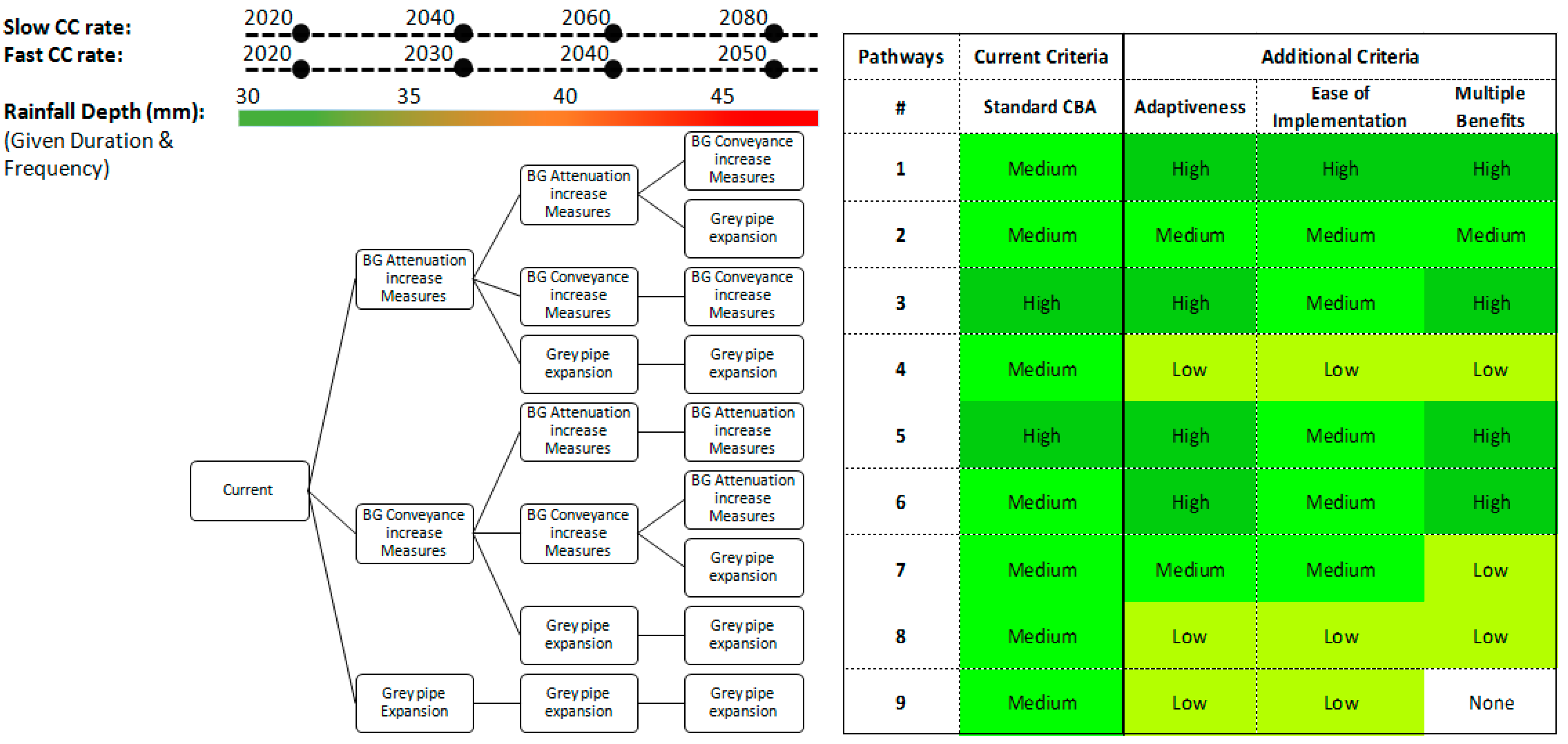
Again using Carshalton to demonstrate new assessment procedures, Cambridge University has developed a roadmap for urban drainage adaptation over the next 40 years, shown conceptually in relation to changing climate inputs Figure 1.
In comparing each of these possible future pathways additional criteria are used to complement conventional cost–benefit analysis, such as indicators of adaptiveness, flexibility, ease of implementation and a monetised and spatial evaluation of the wider multiple benefits that can be delivered by SuDS and blue-green options. The procedures are using the SWMM dynamic rainfall-runoff-routing simulation model (as developed by US Environment Protection Agency (EPA)) to identify when service thresholds are exceeded, triggering the need for further interventions. The integration of a variety of appraisal techniques offers a new perspective to help inform the timing and placement of blue-green interventions, while acknowledging future uncertainties. As an envelope of possible climatic and urbanisation rates are considered, a viable planning horizon becomes evident. The approach provides a pragmatic response to changing drivers of urban flooding allowing real options evaluation techniques to help determine the scale of interventions that are required and when they should be implemented.
2.3. Interoperability
Leeds University have introduced the concept “interoperability” to guide transition from local multifunctionality to city-scale multisystem flood management, through actively managing connections between infrastructure systems to convey, divert and store flood water. They define interoperability as “The ability of any water management system to redirect water and make use of other system(s) to maintain or enhance its performance function during exceedance events” [6].
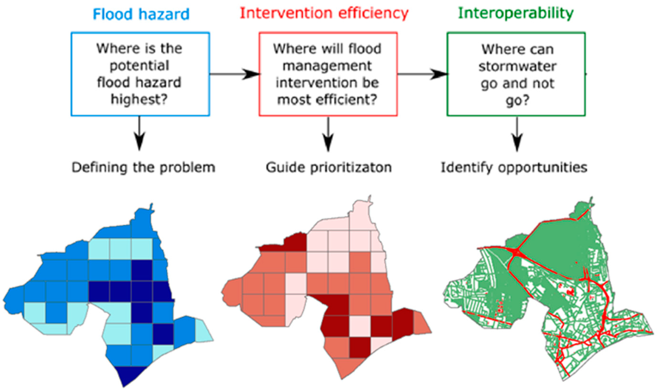
The work is focusing on achieving a better understanding of how flood prone areas are linked to flood source areas within urban catchments and how opportunities for capturing or transferring stormwater along these pathways can be identified. A source to impact analysis is using a transferable modelling approach based on the CityCAT hydrodynamic model to systematically identify locations contributing most to flood hazard within a catchment. This is reported using a spatial analysis framework by synthesising and combing spatial data on (i) flood hazard, (ii) intervention efficiency and (iii) opportunities for interoperability at the catchment scale. Figure 2 illustrates the application of these ideas in the case study city of Newcastle.
The first image (flood hazard) depicts the potential flood hazard from a 1 in 50 year event mostly in the middle to lower part of the city centre. The second image (intervention efficiency) shows flood source areas, which are located mostly in the upper and lower part of the catchment. The third image (interoperability) illustrates the infrastructure systems that can potentially act as a water management asset (green) and systems where additional flood water should be avoided.
This approach can help identify different types of flood source areas and, when combined with information on infrastructure systems, can guide the selection of appropriate flood management solutions from a catchment perspective. Linking flood hazard to flood source areas provides insights into the hydrological processes and spatial interactions within the urban catchment, and can help prioritise locations for flood management intervention.
2.4. Uncovering Implicit Perceptions of Blue-Green Interventions for Flood Resilience
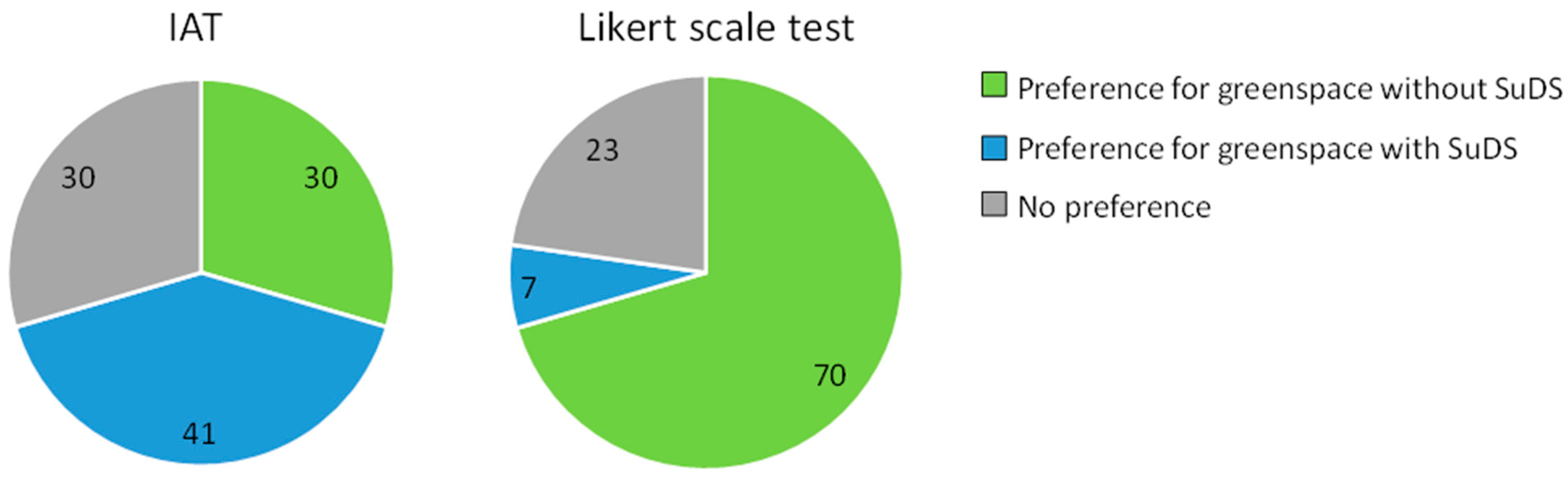
The Universities of Nottingham and the West of England are working to better understand the attitudes and preferences towards blue-green and grey infrastructure in public open space, moving beyond stated preference studies where attributes are openly articulated (e.g., through questionnaires) to developing new Implicit Association Tests (IATs) that measure hidden perceptions and subconscious attitudes.
Explicit and implicit preferences for SuDS in public greenspace were investigated using, respectively, a Likert scale test and an IAT, based on the method presented by Greenwald, McGhee, and Schwartz [11] and using the FreeIAT software (Adam W.Meade, North Carolina State University, Raleigh, CA, USA) [12]. In the IAT, participants responded to photographs (target concepts) illustrating public greenspace with and without SuDS and to positive and negative words representing evaluative attributes. Implicit preferences were calculated based on reaction times. Key findings from a trial with 44 participants in Bristol revealed significant differences between implicit and explicit preferences for public greenspace with and without SuDS. Overall, respondents tended to explicitly prefer greenspace without SuDS (70%, compared with 7% who explicitly preferred greenspace with SuDS) (Figure 3). In contrast, more respondents implicitly preferred public greenspace with SuDS (41%, compared with 30% who implicitly preferred greenspace without SuDS). This suggests that the respondents’ subconscious attitudes are more favourable towards SuDS, rather than just greenspace. The combined explicit–implicit tests provide insight into perceptions of attractiveness, safety and tidiness associated with SuDS and public greenspace which may help blue-green infrastructure be designed in ways that may improve public acceptability of features.
In related work, the Heriot-Watt University team are investigating the potential for SuDS retrofitting at the Houston Industrial Estate, Scotland, assessing the public awareness of SuDS technology, relevant regulations and barriers to retrofit using a questionnaire survey. Most companies were unaware of the Scottish Environmental Protection Agency’s General Binding Rules, which provide statutory controls over certain low risk activities that may affect the water environment in Scotland (e.g., diffuse pollution), although most companies claimed familiarity with some SuDS techniques such as permeable paving and gravel filter drains. Many of the potential plot scale techniques, such as detention basins and larger scale rain gardens, were unfamiliar to most companies and there was a lot of confusion in the understanding of SuDS features. A site survey confirmed the presence or absence of these features on individual plots and compared them to the claims of the site owners. Approximately 40 SuDS features, including detention basins, swales, filter strips and gravel filter drains (and more), were claimed by premises on the industrial estate and yet were not identified as present when the research team conducted their survey. Conversely permeable block paving was ubiquitous across the development but not always recognised as present by the respondents. This work suggests that there is a clear need for sustained engagement and education to raise awareness of SuDS technology and overcome barriers to their adoption in areas where they need to be retrofitted.
2.5. Urban Metabolism Modelling in Ebbsfleet Garden City
Urban metabolism refers to the combination of the technical and socioeconomical processes that occur in cities and that result in growth, production of energy and elimination of waste. The metabolism-based modelling approach led by Exeter University overcomes issues commonly encountered by independent modelling and management of urban water systems (water supply, wastewater and surface water collection) by providing an integrated approach that considers the interconnections and interdependencies of all urban water subsystems. This approach increases resilience to extreme events, from floods to droughts, by enabling the integrated modelling of future water management intervention strategies, such as water harvesting and grey water recycling, and their impact on the performance of downstream infrastructure such as stormwater systems.
The study is using WaterMet2, a mass-balance conceptual urban metabolism modelling tool [13] to evaluate the sustainability performance of the urban water systems in the Ebbsfleet Garden City, over a predefined long-term planning horizon and for a range of future possible intervention strategies. The integrated evaluation of the water and wastewater management master plans of the local water companies (Thames and Southern Water) through WaterMet2 simulations will aid long-term decision making by illustrating the impact of different sustainability strategies, including options for wastewater treatment, on the urban water system.
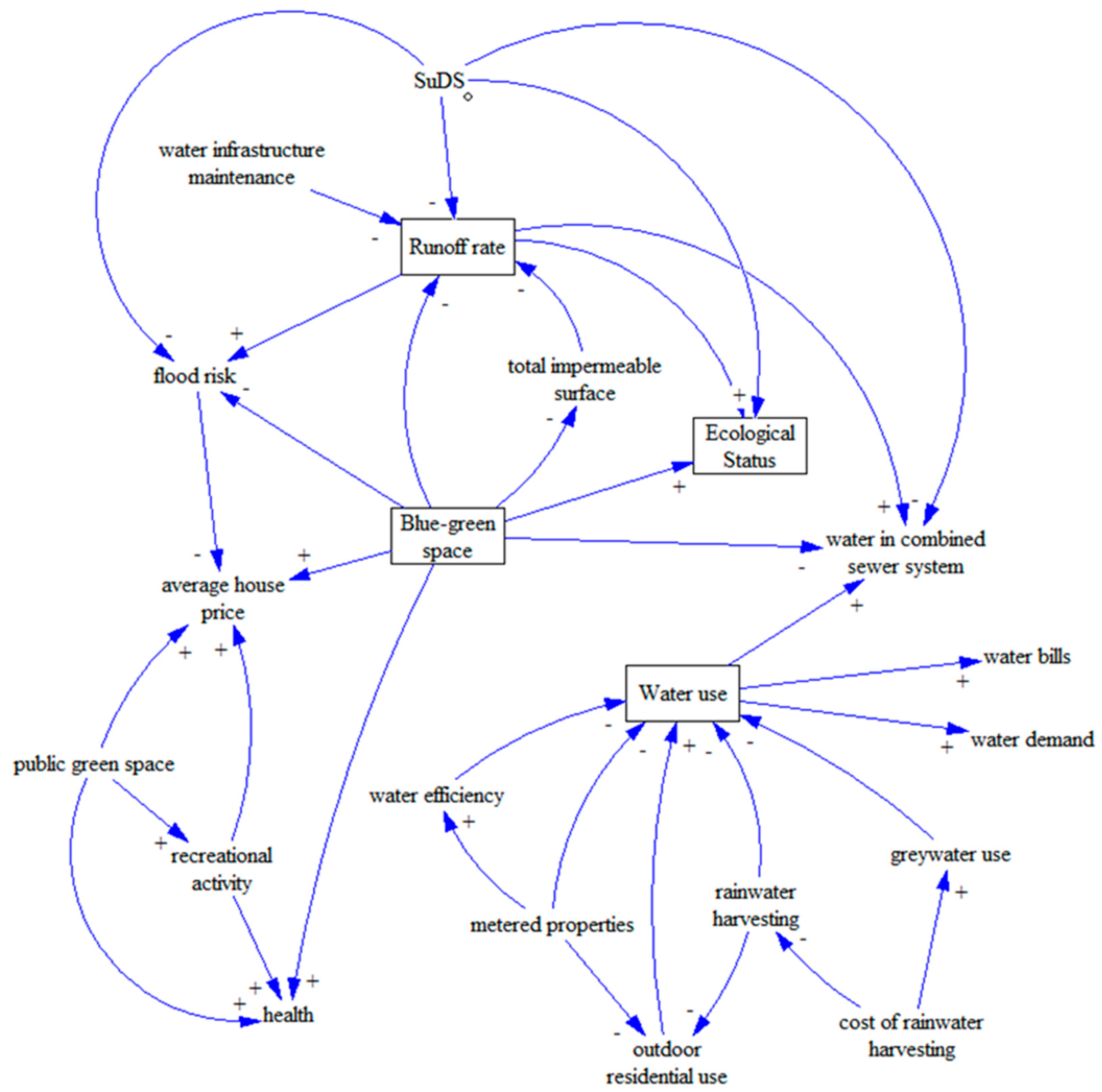
The ultimate aim is to couple this work with a semi-quantitative system dynamics model (currently being coproduced by the Ebbsfleet Water Forum) to further assess sustainable water management options for the Ebbsfleet Garden City. The Ebbsfleet Water Forum, established by the Urban Flood Resilience consortium in 2017 and based on a ‘Learning and Action Alliance’ framework [8], is coordinated by Open University team members and the Ebbsfleet Development Corporation. The vision of the Forum is to incorporate blue-green infrastructure into development design from the outset, and champion urban flood resilience to encourage the realistic delivery of sustainable urban water management. The system dynamics model investigates sustainable water management options for the Garden City, including the reduction of residential potable water use, increased blue-green space and SuDS, and rainwater harvesting. An early causal loop diagram is presented in Figure 4. The system dynamics model is currently being codeveloped iteratively by the project team and Ebbsfleet stakeholders, and will be run under a range of future climate and socioeconomic conditions, and including a range of policy incentives, to enhance the capacity of local stakeholders to influence policy in a more sustainable direction.
2.6. Further Research
Further research of the consortium not reported here includes work by Newcastle University on developing a new comprehensive model of urban hydrosystems, a study of suspended particulate matter and water quality by Heriot-Watt University illustrating ecosystem functioning of SuDS ponds, challenges associated with implementing SuDS through the strengthened English planning system led by the Open University, effective approaches to blue-green infrastructure community engagement by the University of the West of England and Exeter University’s development of Rainwater Management Systems that concurrently reduce stormwater discharges and potable water consumption.
3. Conclusions
Achieving urban flood resilience is a multifaceted problem which requires integrated solutions across a range of disciplines: From advances in modelling the hydrodynamic performance of combined grey and blue-green interventions, and flexible engineering design, to social insights into public perceptions and community acceptability. The work reported in this paper has shown that adopting blue-green approaches which rely on storage and infiltration through vegetated surfaces can contribute to wider Natural Capital in areas subject to rapid urbanisation. Adaptive design pathways that help identify the right balance between grey pipe-based approaches and sustainable drainage systems, and how these can be managed interoperably across urban catchments, are key outputs to date, in addition to research into SuDS perceptions and sustainable water management options through system dynamics modelling, that generate insight into how the public and businesses understand the value of blue-green systems.
Author Contributions
Conceptualization, Writing—Review & Editing: R.F. and E.O.; Section 2.1: S.N., Table 1, Figure 1 and Section 2.2: L.K. and R.F., Section 2.3 and Figure 2: K.V. and D.D., Section 2.4: E.O. and V.K., Section 2.5: S.A.
Funding
This research was performed as part of an interdisciplinary project undertaken by the Urban Flood Resilience Research consortium (www.urbanfloodresilience.ac.uk). This work was supported by the Engineering and Physical Sciences Research Council (grant numbers EP/P004180/1, EP/P003982/1, EP/P004210/1, EP/P004237/1, EP/P004261/1, EP/P004296/1, EP/P004318/1, EP/P004334/1 and EP/P004431/1).
Acknowledgments
The authors acknowledge the contributions of these peoples (Colin Thorne, Scott Arthur, Stephen Birkinshaw, David Butler, Brian D’Arcy, Glyn Everett, Vassilis Glenis, Chris Kilsby, Jessica Lamond, Greg O’Donnell, Karen Potter, Tudor Vilcan, Nigel Wright) in developing the above work.
Conflicts of Interest
The authors declare no conflict of interest. The funders had no role in the design of the study; in the collection, analyses, or interpretation of data; in the writing of the manuscript, and in the decision to publish the result
References
- Urban Flood Resilience Project (2019), Key Project Outputs Report. Available online: http://www.urbanfloodresilience.ac.uk/publications/publications.aspx (accessed on 26 April 2019).
- Glenis, V.; Kutija, V.; Kilsby, C. A fully hydrodynamic urban flood modelling system representing buildings, green space and interventions. Environ. Modell. Softw. 2018, 109, 272–292. [Google Scholar] [CrossRef] [Green Version]
- Fenner, R. Spatial evaluation of multiple benefits to encourage multi-functional design in blue green cities. Water 2017, 9, 953. [Google Scholar] [CrossRef]
- Ahilan, S.; Melville-Shreeve, P.; Kapelan, Z.; Butler, D. The influence of household rainwater harvesting system design on water supply and stormwater management efficiency. In New Trends in Urban Drainage Modelling; Mannina, G., Ed.; Springer: Cham, Swizerland, 2018; pp. 369–374. ISBN 33199986762018. [Google Scholar]
- Costa, J.; Fenner, R.; Kapetas, L. A Screening Tool to Assess the Potential for Energy Recovery from the Discharge of Stormwater Runoff. In Proceedings of the Institution of Civil Engineers-Engineering Sustainability, London, UK, 20 December 2018; ICE Publishing: London, UK, 2018. [Google Scholar] [CrossRef]
- Vercruysse, K.; Dawson, D.; Wright, N. Interoperability: A conceptual framework to bridge the gap between multi-functional and multi-system urban flood management. J. Flood Risk Manag. 2019. [Google Scholar] [CrossRef]
- Everett, G.; Lamond, J. Considering the value of community engagement for (co-) producing Blue-Green infrastructure. In Urban Water Systems & Floods II. WIT Transactions on the Built Environment; WIT Press: Southampton, UK, 2018; Volume 184, pp. 1–14. [Google Scholar]
- O’Donnell, E.; Lamond, J.; Thorne, C. Learning and Action Alliance framework to facilitate stakeholder collaboration and social learning in urban flood risk management. Environ. Sci. Policy 2018, 80, 1–8. [Google Scholar] [CrossRef]
- Guerry, A.D.; Polasky, S.; Lubchenco, J.; Chaplin-Kramer, R.; Daily, G.C.; Griffin, R.; Ruckelshaus, M.; Bateman, I.J.; Duraiappah, A.; Elmqvist, T.; et al. Natural capital and ecosystem services informing decisions: From promise to practice. Proc. Natl. Acad. Sci. USA 2015, 112, 7348–7355. [Google Scholar] [CrossRef] [PubMed] [Green Version]
- Holzinger, O.; Sadler, J.; Scott, A. Natural Capital Planning Tool. 2018. Available online: http://ncptool.com/ressources/ (accessed on 12 April 2019).
- Greenwald, A.G.; McGhee, D.E.; Schwartz, J.L. Measuring individual differences in implicit cognition: The implicit association test. J. Person. Soci. Psychol. 1998, 74, 1464. [Google Scholar] [CrossRef]
- Meade, A.W. FreeIAT: An open-source program to administer the implicit association test. Appl. Psychol. Meas. 2019, 33, 643. [Google Scholar] [CrossRef]
- Behzadian, K.; Kapelan, Z. Modelling metabolism based performance of an urban water system using Water MET 2. Resour. Conserv. Recycl. 2015, 99, 84–99. [Google Scholar] [CrossRef]
Figure 1.
Assessment of adaptation pathways to meet uncertainties in future climate.

Figure 2.
Geographic information system (GIS) analysis of flood impacts across Newcastle.

Figure 3.
Attitudes towards sustainable drainage systems (SuDS) in public greenspace evaluated via an Implicit Association Tests (IAT) and Likert scale test (explicit measure). Sample population consists of 44 respondents in Bristol, UK, who completed the tests in May–July 2018.
Figure 3.
Attitudes towards sustainable drainage systems (SuDS) in public greenspace evaluated via an Implicit Association Tests (IAT) and Likert scale test (explicit measure). Sample population consists of 44 respondents in Bristol, UK, who completed the tests in May–July 2018.

Figure 4.
Early version of the causal loop diagram created by the project team and members of the Ebbsfleet Water Forum illustrating variables and linkages in response to a discussion of sustainable water management options for the Ebbsfleet Garden City.
Figure 4.
Early version of the causal loop diagram created by the project team and members of the Ebbsfleet Water Forum illustrating variables and linkages in response to a discussion of sustainable water management options for the Ebbsfleet Garden City.


Table 1.
Natural capital impact scores of blue-green infrastructure options on ecosystem services.
| Ecosystem Service | Impact Score | ||
|---|---|---|---|
| Swales | Green Roofs | Rain Gardens | |
| Harvested Products (rainwater) | n/a * | negative | negative |
| Biodiversity | positive | negative | positive |
| Aesthetic Values | positive | positive | positive |
| Recreation | positive | negative | negative |
| Water Quality Regulation | n/a | negative | n/a |
| Flood Risk Regulation | n/a | negative | n/a |
| Air Quality Regulation | positive | negative | negative |
| Local Climate Regulation | positive | positive | positive |
| Global Climate Regulation | positive | negative | positive |
| Soil Contamination | n/a | n/a | n/a |
* n/a is not applicable.
© 2019 by the authors. Licensee MDPI, Basel, Switzerland. This article is an open access article distributed under the terms and conditions of the Creative Commons Attribution (CC BY) license (http://creativecommons.org/licenses/by/4.0/).
Share and Cite
MDPI and ACS Style
Fenner, R.; O’Donnell, E.; Ahilan, S.; Dawson, D.; Kapetas, L.; Krivtsov, V.; Ncube, S.; Vercruysse, K. Achieving Urban Flood Resilience in an Uncertain Future. Water 2019, 11, 1082. https://doi.org/10.3390/w11051082
AMA Style
Fenner R, O’Donnell E, Ahilan S, Dawson D, Kapetas L, Krivtsov V, Ncube S, Vercruysse K. Achieving Urban Flood Resilience in an Uncertain Future. Water. 2019; 11(5):1082. https://doi.org/10.3390/w11051082
Chicago/Turabian StyleFenner, Richard, Emily O’Donnell, Sangaralingam Ahilan, David Dawson, Leon Kapetas, Vladimir Krivtsov, Sikhululekile Ncube, and Kim Vercruysse. 2019. "Achieving Urban Flood Resilience in an Uncertain Future" Water 11, no. 5: 1082. https://doi.org/10.3390/w11051082
Note that from the first issue of 2016, this journal uses article numbers instead of page numbers. See further details here.