Assessing Water Shortage through a Balance Model among Transfers, Groundwater, Desalination, Wastewater Reuse, and Water Demands (SE Spain)


Abstract
:1. Introduction
- At the national level, the most important bodies are River Basin Authorities, which have responsibilities for hydrological planning, discharge authorizations, or concessions. Additionally, the MCT institution is an autonomous organization of the Ministry for the Ecological Transition (traditionally called Ministry of Environment), whose aim is the supply of urban and industrial water to the primary network (collection, purification or desalination, piping, and storage in water reserve tanks) in 80 municipalities of the Alicante, Murcia, and Albacete regions. Another State institution is Acuamed, a public company with the objectives of hire, build, acquire, and operate hydraulic infrastructures, especially desalination plants, in the Segura, Júcar, Ebro, Andalusian Mediterranean, and Internal Catalonia water basins. With reference to agricultural institutions, the State Company of Agricultural Structures (SEIASA), attached to the Ministry of Finance and Civil Service, is responsible for the promotion, contracting, financing, exploitation, and technical support of the modernization and consolidation of the irrigations included in the National Irrigation Plan and defined as general interest. On the other hand, the Tragsa Group belongs to the group of companies of the State-owned holding entity Sociedad Estatal de Participaciones Industriales (SEPI) and works in different sectors such as the stock of agricultural, livestock, forestry, and rural growth services, or the protection and conservation of the environment [2,4,6,11,16].
- At the regional level, the Generalitat Valenciana is the government entity under which the Spanish autonomous community of Valencia is politically ordered and develops significant competences in environment and agriculture, through different agencies and departments. Particularly important is the Entidad Pública de Saneamiento de Aguas Residuales (EPSAR), the public wastewater sanitation company, which manages the construction and operation of treatment plants in cooperation with town councils and association bodies [16,20].
- At the provincial level, the provincial government (Diputación de Alicante) focuses on legal, economic, and technical assistance to municipalities (generally, small municipalities) for the provision of municipal water service, through its area called Ciclo Hídrico or the public entity Proaguas Costablanca [21].
- At the municipal level, local companies control water management in the secondary phase (water supply) as a compulsory minimum local public service. Nevertheless, local entities can choose the type of management through a range of possibilities: direct concentrated or direct decentralized, as well as indirect management (predominant in Alicante province), via concessions to private companies or by the creation of joint ventures [2,16,21].
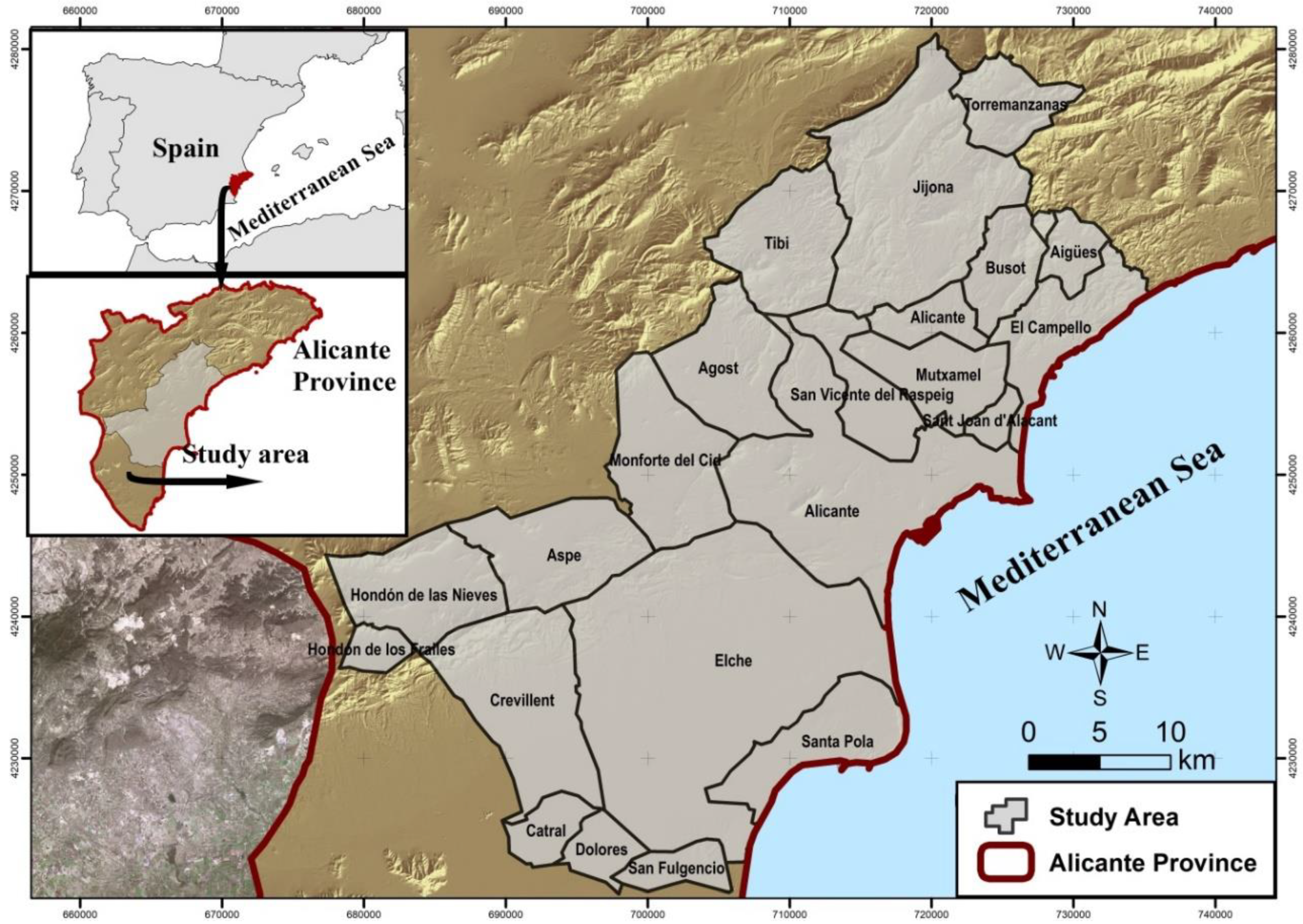
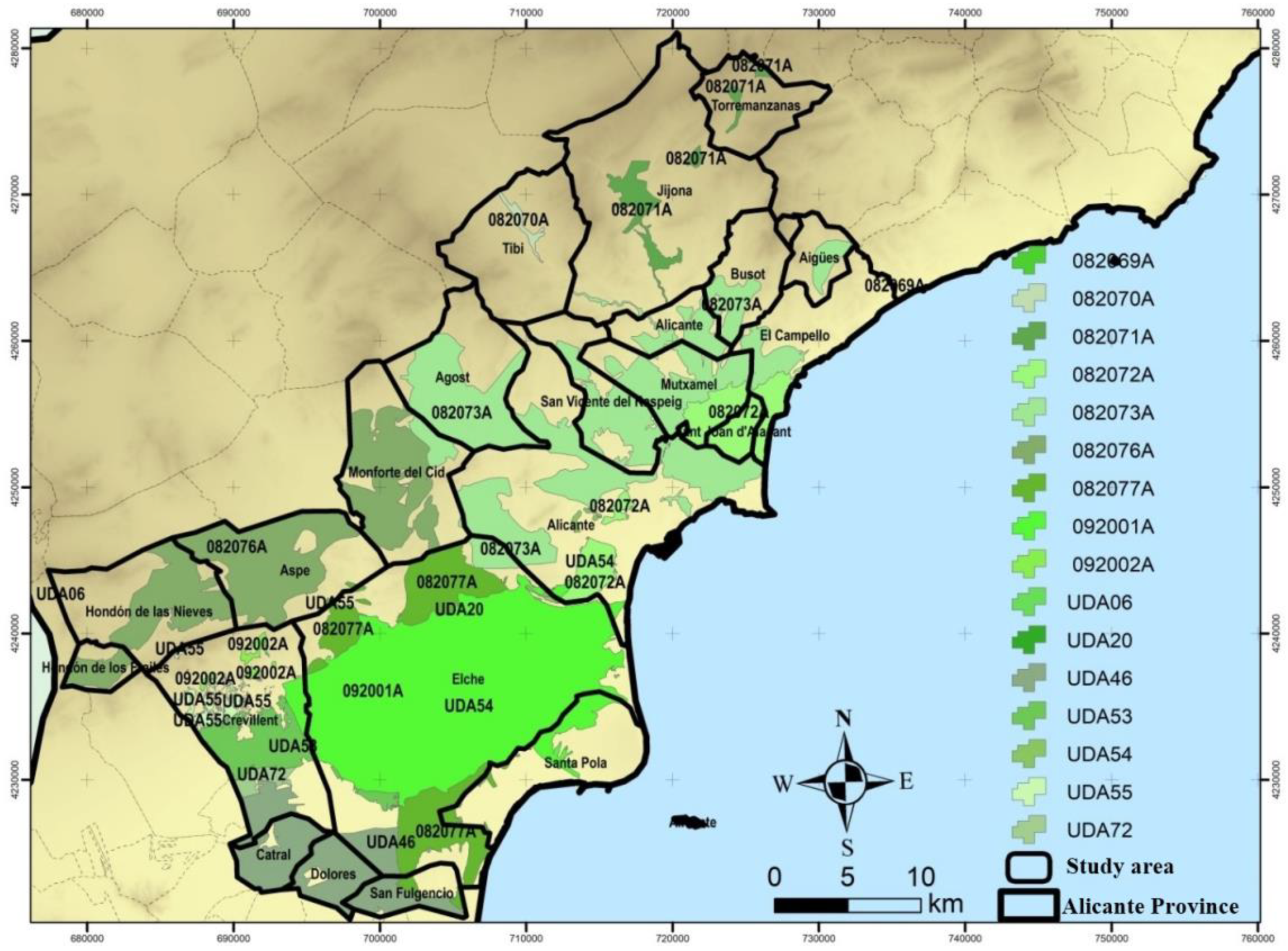
2. Study Area
3. Methodology
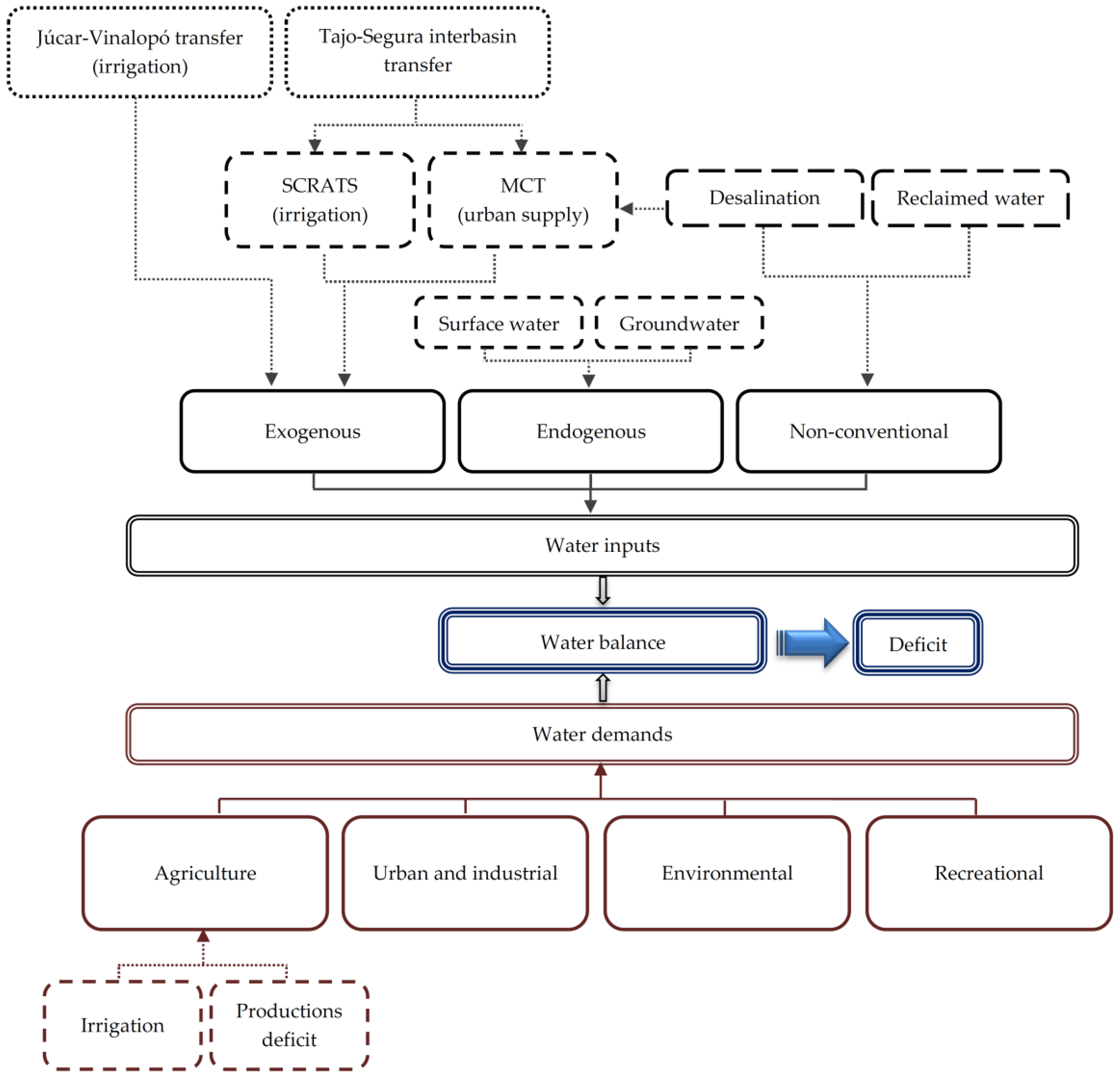
4. Water Inputs
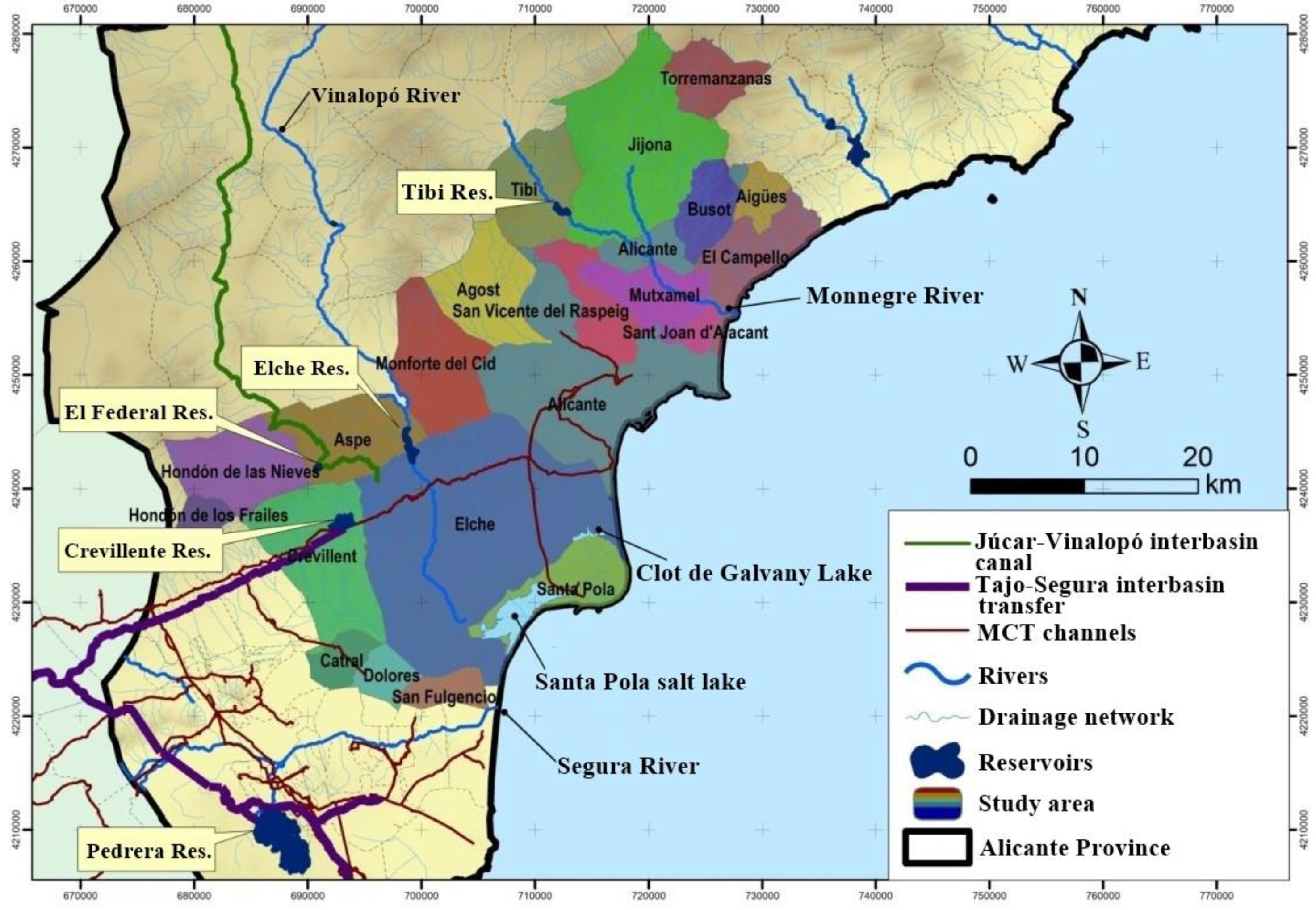
4.1. Surface and Groundwater Resources
- The Pedrera reservoir, despite being outside the borders of the study area, could be encompassed in the global management system illustrated in Figure 3 as its resources are used to supply municipalities located in the southern part of the study area. These resources are conducted to these municipalities through the following hydraulic constructions: Tajo-Segura interbasin water transfer and channels from MCT [16,35,37].
- The Cid canal. Aguas Municipalizadas de Alicante Empresa Mixta (AMAEM) is a joint venture which manages the resources of this canal and supplies the following municipalities in the study area: San Juan and El Campello, which do not depend on the MCT, together with San Vicente del Raspeig and Alicante, which are supplied by the MCT as well [2,16]. In particular, the Cid canal, built in the 19th century [39], has an important infrastructure for collecting and transporting water from the Jumilla-Villena, Yecla-Villena-Benejama, and Peñarrubia aquifers. However, this system is subjected to the availability of groundwater in these aquifers, often with overexploitation problems [18,21,26,27,40].
- The Huerta canal. This canal supplies four municipalities of Alicante province. Two of them are involved in the study area: Agost and Mutxamel [16,18]. However, it should be noted that, currently, this canal does not provide a relevant water supply, since the transferred resources to these four municipalities represent only 3.10% of the total annual volume of water used in Alicante province [2,18,21].
4.2. Non-Conventional Resources: Wastewater Reuse and Desalinated Water
5. Water Demands
5.1. Agricultural, Environmental, and Recreational Demands
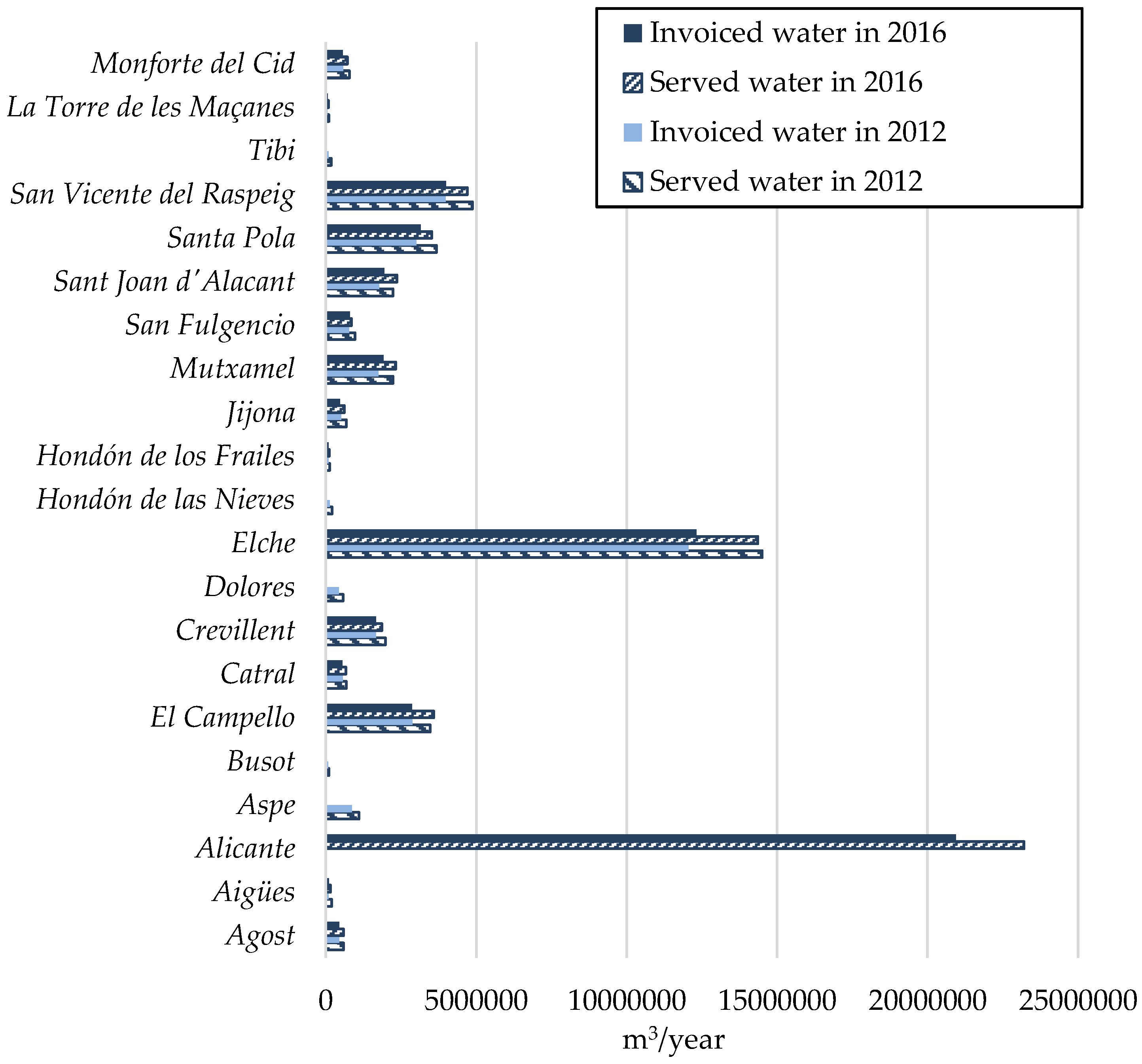
5.2. Urban and Industrial Demands: Municipal Supply and Efficiency
6. Results and Discussion
7. Conclusions
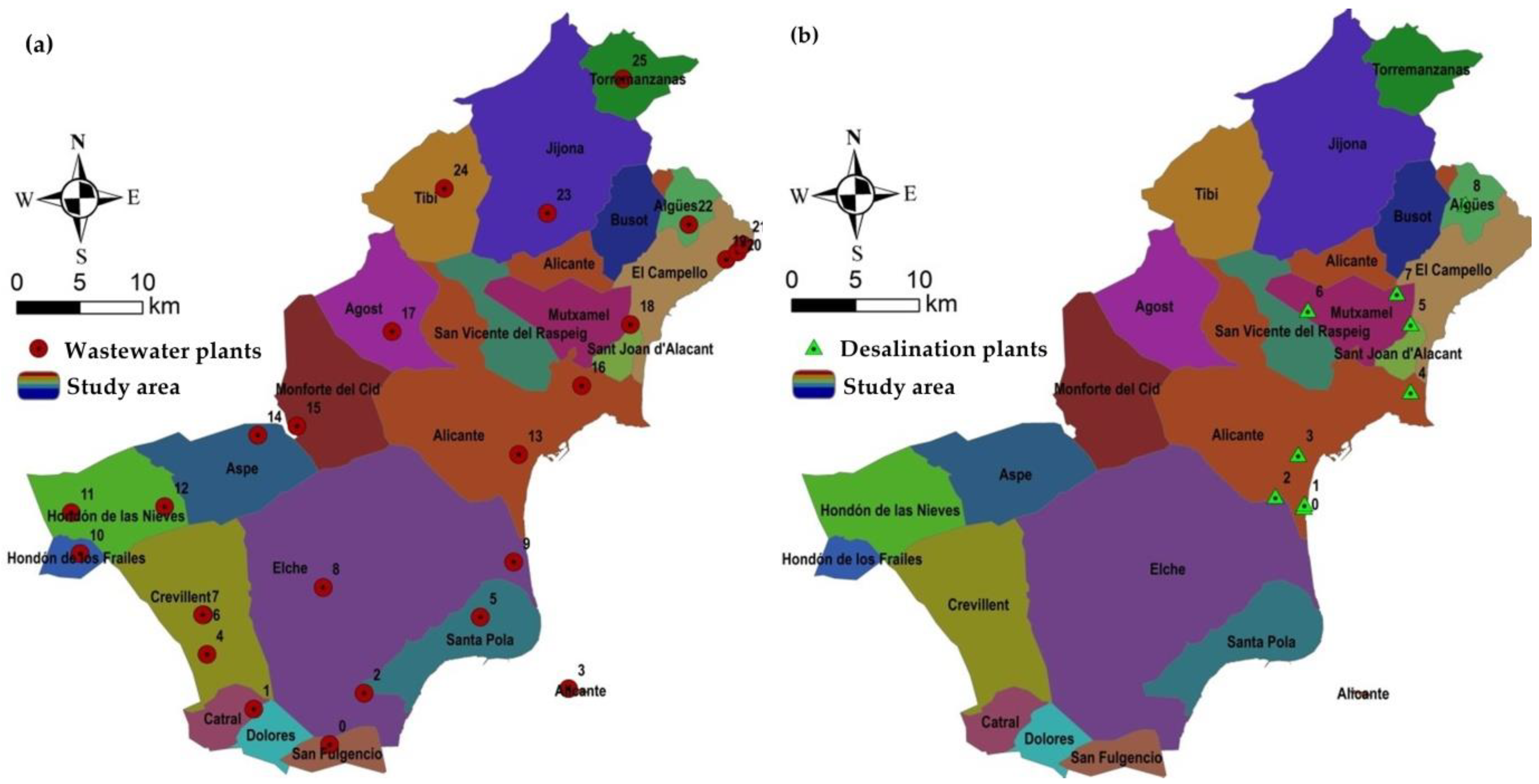
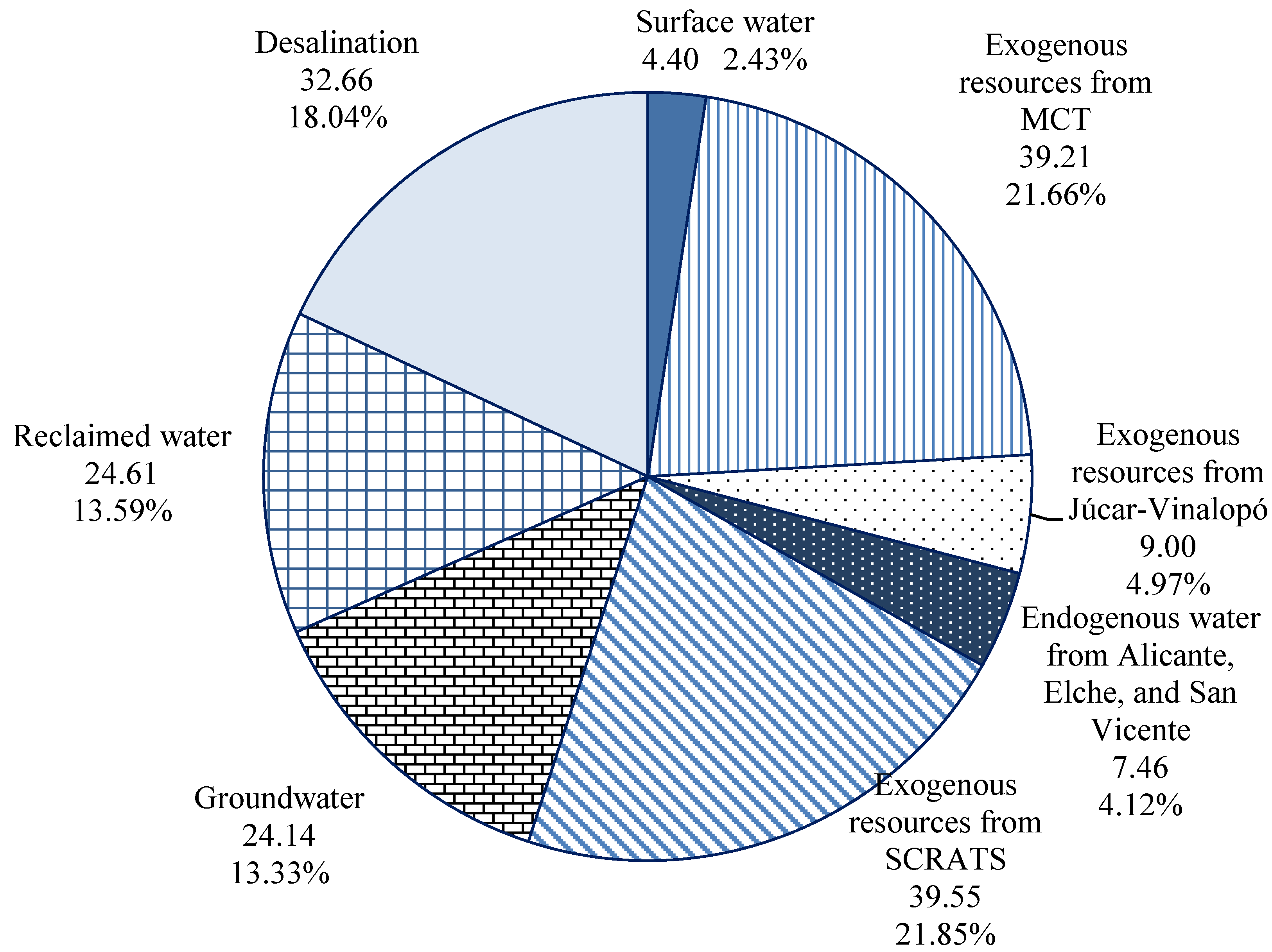
- In the study area, 25 wastewater plants have been identified, treating a total water flow of 46.05 hm3/year. Of this volume, 53.4% (24.61 hm3/year) is reused, 10.8% (4.99 hm3/year) is discharged into riverbeds and, finally, 35.7% (16.46 hm3/year) is discharged into the Mediterranean Sea. Therefore, if a significant share of these discharged flows could be recovered as reclaimed water, the intensive exploitation of coastal aquifers would be reduced. In addition, this could be an opportunity to satisfy mandatory principles, related to wastewater treatment, put in place by European Directives.
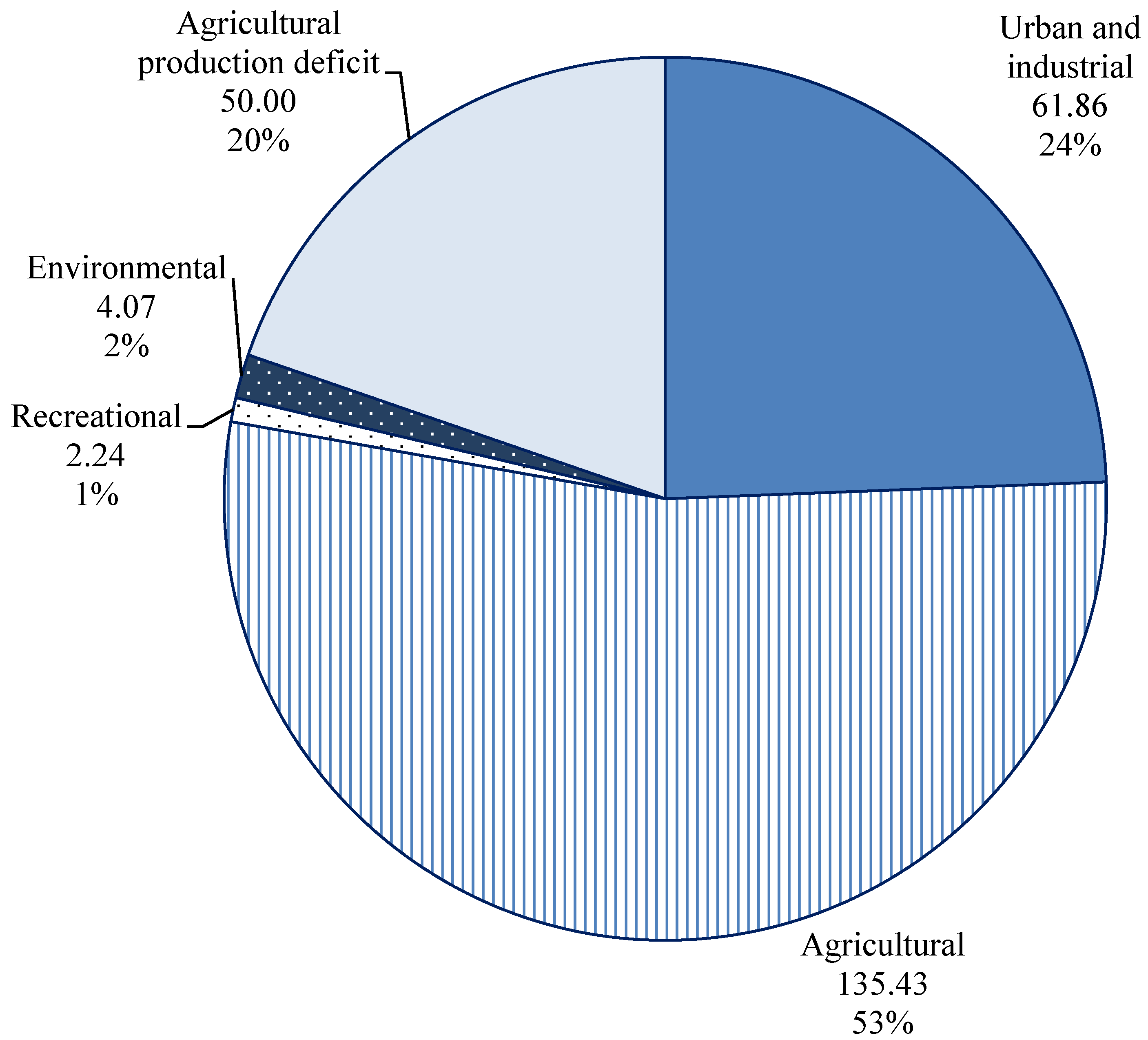
- Regarding water transfers in the study area, they must be preserved, as the contributions of the Tajo-Segura interbasin transfer are the guarantee for urban and agrarian supply and as a strategic element for socioeconomic growth. Concerning the planned irrigation program and the continuity of existing crops, they represent another strategic objective whose inadequate supply must be corrected by means of the necessary inputs, modernization, and high efficiency systems. Similarly, the Júcar-Vinalopó water transfer should be reactivated, taking into account that this conduction has gradually been transporting minor flows (e.g., 9 hm3/year and 4 hm3/year) over the last few years, essentially due to several political disagreements and water governance issues, for which new participatory exploitation rules should be established.
- Finally, from the perspective of urban and industrial demands, the integration of municipalities into supra-municipal networks should be promoted, since efficiency increases when it occurs in certain municipalities, with guaranteed development thanks to good water governance schemes implemented by entities such as MCT or AMAEM [2].
Author Contributions
Funding
Acknowledgments
Conflicts of Interest
References
- Molina-Giménez, A.; Melgarejo-Moreno, J. Water policy in Spain: seeking a balance between transfers, desalination and wastewater reuse. Int. J. Water Resour. Dev. 2015, 32, 781–798. [Google Scholar] [CrossRef]
- Melgarejo-Moreno, J.; López-Ortiz, M.I.; Fernández-Aracil, P. Water distribution management in South-East Spain: A guaranteed system in a context of scarce resources. Sci. Total Environ. 2019, 648, 1384–1393. [Google Scholar] [CrossRef]
- Kalavrouziotis, I.K.; Arambatzis, C.; Kalfountzos, D.; Varnavas, S.P. Wastewater Reuse Planning in Agriculture: The Case of Aitoloakarnania, Western Greece. Water 2011, 3, 988–1004. [Google Scholar] [CrossRef] [Green Version]
- CHS, Confederación Hidrográfica del Segura. Plan. Hidrológico de la Demarcación del Segura, Memoria; Ministry of Agriculture, Food and Environment (Spain): Murcia, Spain, 2016; pp. 1–762. [Google Scholar]
- Valdes-Abellan, J.; Pardo, M.A.; Tenza-Abril, A.J. Observed precipitation trend changes in the western Mediterranean region. Int. J. Clim. 2017, 37, 1285–1296. [Google Scholar] [CrossRef]
- CHJ, Confederación Hidrográfica del Júcar. Plan Hidrológico de la Demarcación Hidrográfica del Júcar. Memoria. Ciclo de planificación hidrológica 2015–2021; Ministry of Agriculture, Food and Environment (Spain): Valencia, Spain, 2015; p. 896. [Google Scholar]
- Morote, Á.-F.; Olcina, J.; Hernández, M. The Use of Non-Conventional Water Resources as a Means of Adaptation to Drought and Climate Change in Semi-Arid Regions: South-Eastern Spain. Water 2019, 11, 93. [Google Scholar] [CrossRef]
- Martínez-Ibarra, E. A geographical approach to post-flood analysis: The extreme flood event of 12 October 2007 in Calpe (Spain). Appl. Geogr. 2012, 32, 490–500. [Google Scholar] [CrossRef]
- Olcina-Cantos, J.; Hernández-Hernández, M.; Rico-Amorós, A.M.; Martínez-Ibarra, E. Increased risk of flooding on the coast of Alicante (Region of Valencia, Spain). Hazards Earth Sci. 2010, 10, 2229–2234. [Google Scholar] [CrossRef] [Green Version]
- Jodar-Abellan, A.; Valdes-Abellan, J.; Pla, C.; Gomariz-Castillo, F. Impact of land use changes on flash flood prediction using a sub-daily SWAT model in five Mediterranean ungauged watersheds (SE Spain). Sci. Total Environ. 2019, 657, 1578–1591. [Google Scholar] [CrossRef]
- Aldaya, M.M.; Custodio, E.; Llamas, R.; Fernández, M.F.; García, J.; Ródenas, M.A. An academic analysis with recommendations for water management and planning at the basin scale: A review of water planning in the Segura River Basin. Sci. Total Environ. 2019, 662, 755–768. [Google Scholar] [CrossRef] [PubMed]
- PATAE. Documento Inicial Estratégico del Plan. de Acción Territorial de las Áreas Metropolitanas de Alicante y Elche (PATAE); Generalitat Valenciana: Alicante, Spain, 2018; p. 118. [Google Scholar]
- Interlandi, S.J.; Crockett, C.S. Recent water quality trends in the Schuykill River, Pennsylvania, USA: a preliminary assessment of the relative influences of climate, river discharge and suburban development. Water Res. 2003, 37, 1737–1748. [Google Scholar] [CrossRef]
- Xu, C.Y. Estimation of Parameters of a Conceptual Water Balance Model for Ungauged Catchments. Water Resour. Manag. 1999, 13, 353–368. [Google Scholar] [CrossRef]
- Zhou, Y.; Herath, H.M.P.S.D. Evaluation of alternative conceptual models for groundwater modelling. Geosci. Front. 2017, 8, 437–443. [Google Scholar] [CrossRef] [Green Version]
- Melgarejo-Moreno, J.; Molina-Giménez, A. La Mancomunidad de los Canales del Taibilla en la Provincia de Alicante; University of Alicante: Alicante, Spain, 2017. [Google Scholar]
- Prats, D.; Melgarejo, J. Desalación y Reutilización de Aguas. Situación en la Provincia de Alicante; Confederación Empresarial de la Provincia de Alicante (COEPA): Alicante, Spain, 2006; p. 172. [Google Scholar]
- Melgarejo-Moreno, J.E. Repercusiones Socioeconómicas del Plan. Hidrológico Nacional en la Provincia de Alicante; Fundación COEPA; Instituto Universitario del Agua y las Ciencias Ambientales (Universidad de Alicante): Alicante, Spain, 2004; 349p, ISBN 84-933835-0-3. [Google Scholar]
- Peña-Guzmán, C.A.; Melgarejo, J.; Prats, D.; Torres, A.; Martínez, S. Urban Water Cycle Simulation/Management Models: A Review. Water 2017, 9, 285–314. [Google Scholar] [CrossRef]
- EPSAR; Entidad Pública de Saneamiento de Aguas residuales (EPSAR). Private communication, 2018.
- DPA-IGME. Atlas Hidrogeológico de la Provincia de Alicante; Excelentísima Diputación Provincial de Alicante (DPA)-Ciclo Hídrico, Instituto Geológico y Minero de España (IGME): Alicante, Spain, 2015. [Google Scholar]
- Pérez-Morales, A.; Gil-Guirado, S.; Olcina-Cantos, J. Housing bubbles and the increase of flood exposure. Failures in flood risk management on the Spanish south-eastern coast (1975–2013). J. Flood Risk Manag. 2015, 11, S302–S313. [Google Scholar] [CrossRef]
- Sánchez-Galiano, J.C.; Martí-Ciriquián, P.; Fernández-Aracil, P. Temporary population estimates of mass tourism destinations: The case of Benidorm. Tour. Manag. 2017, 62, 234–240. [Google Scholar] [CrossRef]
- Instituto Nacional de Estadística (INE). España. Available online: http://www.ine.es/ (accessed on 5 May 2018).
- Tohuami, I.; Andreu-Rodes, J.M.; Chirino, E.; Sánchez, J.R.; Moutahir, H.; Pulido-Bosch, A.; Martínez-Santos, P.; Bellot, J. Recharge estimation of a small karstic aquifer in a semi-arid Mediterranean region (southeastern Spain) using a hydrological model. Hydrol. Process. 2013, 27, 165–174. [Google Scholar] [CrossRef]
- Vallejos, A.; Andreu-Rodes, J.M.; Sola, F.; Pulido-Bosch, A. The anthropogenic impact on Mediterranean karst aquifers: cases of some Spanish aquifers. Environ. Earth Sci. 2015, 74, 185–198. [Google Scholar] [CrossRef]
- Werner, A.D.; Zhang, Q.; Xue, L.; Smerdon, B.D.; Li, X.; Zhu, X.; Yu, L.; Li, L. An Initial Inventory and Indexation of Groundwater Mega-Depletion Cases. Water Resour. Manag. 2013, 27, 507–533. [Google Scholar] [CrossRef]
- Pulido-Velazquez, D.; Garcia-Arostegui, J.L.; Molina, J.L.; Pulido-Velazquez, M. Assessment of future groundwater recharge in semi-arid regions under climate change scenarios (Serral-Salinas aquifer, SE Spain). Could increased rainfall variability increase the recharge rate? Hydrol. Process. 2015, 29, 828–844. [Google Scholar] [CrossRef]
- Custodio, E.; Andreu-Rodes, J.M.; Aragón, R.; Estrela, T.; Ferrer, J.; García-Aróstegui, J.L.; Manzano, M.; Rodríguez-Hernández, L.; Sahuquillo, A.; del Villar, A. Groundwater intensive use and mining in south-eastern peninsular Spain: Hydrogeological, economic and social aspects. Sci. Total Environ. 2016, 559, 302–316. [Google Scholar] [CrossRef] [PubMed] [Green Version]
- Zarzo, D.; Prats, D. Desalination and energy consumption. What can we expect in the near future? Desalination 2018, 427, 1–9. [Google Scholar] [CrossRef]
- Prats-Rico, D. Reuse of Purified Regenerated Water Worldwide: Analyzes and Projections. Water lands. 2016, 8, 10–21. [Google Scholar] [CrossRef]
- R-CRAN. R: A Language and Environment for Statistical Computing. Available online: https://www.r-project.org/ (accessed on 22 November 2018).
- ArcGIS. ArcGIS 10.5 (Geographic Information System). Available online: https://support.esri.com/es/downloads (accessed on 16 November 2018).
- Confederación Hidrográfica del Júcar (CHJ). Descarga de Datos y Cartografía. Available online: http://aps.chj.es/down/html/descargas.html (accessed on 8 April 2018).
- Confederación Hidrográfica del Segura (CHS). Descarga de cartografía. Available online: https://www.chsegura.es/chs/cuenca/resumendedatosbasicos/cartografia/ (accessed on 9 March 2018).
- MAPAMA. Ministerio de Agricultura, Medio Ambiente. Descargas. Available online: http://www.mapama.gob.es/es/cartografia-y-sig/ide/descargas/agua/default.aspx (accessed on 4 April 2018).
- Mancomunidad de los Canales del Taibilla (MCT). Sistema de Información Geográfica. Available online: https://www.mct.es/web/mct/sig (accessed on 2 April 2018).
- MAPAMA. Tramos de ríos de España clasificados según Pfafstetter modificado. Available online: http://www.mapama.gob.es/es/cartografia-y-sig/ide/descargas/agua/red-hidrografica.aspx (accessed on 6 April 2017).
- Vines-Martinez, S. Memoria del Proyecto de Conducción de las Aguas del Canal del Cid. 1887. Available online: http://www.cervantesvirtual.com/obra/memoria-del-proyecto-de-conduccion-de-las-aguas-del-canal-del-cid/ (accessed on 13 May 2019).
- Aguas Municipalizadas de Alicante Empresa Mixta (AMAEM). Historia. Available online: http://www.aguasdealicante.es/Historia/ (accessed on 3 April 2018).
- Aguas de Elche. Available online: http://www.aigueselx.com/ESP/58.asp (accessed on 1 April 2018).
- WFD. Directive 2000/60/EC of The European Parliament and of The Council of 23 October 2000 Establishing a Framework for Community Action in the Field of Water Policy; European Communities: Brussels, Belgium, 2000. [Google Scholar]
- Plan Hidrológico de la parte española de la Demarcación Hidrográfica del Ebro 2015–2021. MEMORIA. 2015. Available online: http://www.chebro.es:81/Plan%20Hidrologico%20Ebro%202015-2021/2%20Revisi%C3%B3n%202015-21%20del%20Plan%20Hidrol%C3%B3gico%20del%20Ebro/2.3%20Memoria/2.3.1.-%20Memoria/Memoria_PHE_2015-21_V2.6.pdf (accessed on 13 May 2019).
- CHJ. Plan Hidrológico de la Demarcación Hidrográfica del Júcar Memoria-Anejo 12. Evaluación del Estado de las Masas de Agua Superficial y Subterránea. Ciclo de planificación hidrológica 2015–2021. Available online: https://www.chj.es/Descargas/ProyectosOPH/Consulta%20publica/PHC-2015-2021/PHJ1521_Anejo12_Estado_151126.pdf (accessed on 13 May 2019).
- CHS. Anejo 3: Usos y Demandas. Plan Hidrológico de la Demarcación del Segura 2015/21; Demarcación Hidrográfica del Segura: Murcia, Spain, 2015. [Google Scholar]
- Senent-Alonso, M.; García-Aróstegui, J.L. Sobreexplotación de Acuíferos en la Cuenca del Segura; Fundación Instituto Euromediterráneo del Agua: Murcia, Spain, 2014; p. 231. ISBN 978-84-92988-22-8. [Google Scholar]
- Melgarejo-Moreno, J.; López-Ortiz, M.I. Depuración y reutilización de aguas en España (Wastewater Treatment and Water Reuse in Spain). AGUA TERRITORIO 2016, 22–35. [Google Scholar] [CrossRef]
- Jodar-Abellan, A.; Fernández-Aracil, P.; Melgarejo-Moreno, J. Análisis del Recurso Agua. Plan de Acción Territorial del Área Funcional Alicante-Elche; Technical Report; University institute of the Water and the Environmental Sciences (University of Alicante): Alicante, Spain, 2018; 28p. [Google Scholar]
- Melgarejo-Moreno, J.; Molina-Giménez, A.; Fernández-Aracil, P. 100 años de Riegos de Levante, Izquierda del Segura; Publicaciones de la Universidad de Alicante: Alicante, Spain, 2019; 327p, ISBN 978-8413020204. [Google Scholar]
- Ortuño, A.; Civera, S. El Riego en los Campos de Golf. El caso de la Provincia de Alicante (España) bajo una Comparativa Internacional; Publicaciones de la Universidad de Alicante: Alicante, Spain, 2013; ISBN 978-84-9717-248-6. [Google Scholar]
- CESEL. Actual Cost of Services of Local Entities; Ministry of Finance and Civil Service. Available online: https://serviciostelematicos.minhap.gob.es/Cesel/Consulta/Consulta.aspx (accessed on 10 November 2017).
- Morote, A.; Hernández Hernández, M. Unauthorised Domestic Water Consumption in the City of Alicante (Spain): A Consideration of Its Causes and Urban Distribution (2005–2017). Water 2018, 10, 851. [Google Scholar] [CrossRef]
- Morote, A.; Hernández Hernández, M.; Rico-Amorós, A.M. Causes of Domestic Water Consumption Trends in the City of Alicante: Exploring the Links between the Housing Bubble, the Types of Housing and the Socio-Economic Factors. Water 2016, 8, 374. [Google Scholar] [CrossRef]
- Ciclo-Hídrico; Diputación de Alicante, Registers on water consumption of Ciclo Hídrico. Private communication, 2017.
- Candela, L.; Elorza, F.J.; Jiménez-Martínez, J.; Von-Igel, W. Global change and agricultural management options for groundwater sustainability. Comput. Electron. Agric. 2012, 86, 120–130. [Google Scholar] [CrossRef]
- Grindlay, A.L.; Zamorano, M.; Rodríguez, M.I.; Molero, E.; Urrea, M.A. Implementation of the European Water Framework Directive: Integration of hydrological and regional planning at the Segura River Basin, southeast Spain. Land Use Policy 2011, 28, 242–256. [Google Scholar] [CrossRef]
- DPA. Diputación de Alicante, Pacto Provincial del Agua. Available online: https://ciclohidrico.com/download/pacto-provincial-del-agua/ (accessed on 3 September 2018).


| Groundwater Body | Available Resource (hm3/year) | Extraction (hm3/year) | Exploitation Index |
|---|---|---|---|
| Hoya de Castalla | 1.02 | 0.43 | 0.42 |
| Barrancones-Carrasqueta | 4.50 | 2.78 | 0.62 |
| Sierra Aitana | 0.65 | 0.12 | 0.18 |
| Argüeña-Maigmó | 0.22 | 0.20 | 0.88 |
| Orcheta | 4.52 | 1.74 | 0.38 |
| San Juan-Benidorm | 2.99 | 1.58 | 0.53 |
| Agost-Monnegre | 6.80 | 0.90 | 0.13 |
| Sierra del Cid | 1.40 | 1.00 | 0.71 |
| Sierra de Argallet | 0.23 | 0.38 | 1.63 |
| Sierra de Crevillente | 2.39 | 8.05 | 3.38 |
| Bajo Vinalopó | 20.53 | 2.02 | 0.10 |
| Impermeable 21 | - | - | - |
| Impermeable 24 | - | - | - |
| Impermeable 25 | - | - | - |
| Vega Media y Baja del Segura | 11.38 | 4.94 | 0.43 |
| ∑ = | 56.62 | 24.14 | - |
| Wastewater Plant (Number in Figure 3) | Treated Annual Flow (hm³/year) | Reused Annual Flow (hm³/year) | Reused Flow with Respect to Treated Flow (%) |
|---|---|---|---|
| San Fulgencio-Daya Nueva-Daya Vieja (0) | 0.83 | 0.83 | 100 |
| Dolores-Catral (1) | 0.77 | 0.77 | 100 |
| Elx Carrizales (2) | 0.31 | 0.31 | 100 |
| Alacant Isla de Tabarca (3) | 0.02 | 0.00 | 0.00 |
| Crevillente Realengo (4) | 0.03 | 0.03 | 100 |
| Santa Pola (5) | 2.78 | 2.78 | 100 |
| Crevillente-Derramador Urbana (6) | 0.87 | 0.87 | 100 |
| Crevillente-Derramador Industrial (7) | 0.34 | 0.00 | 0.00 |
| Elx Algoros (8) | 7.98 | 7.98 | 100 |
| Elx Arenales (9) | 1.19 | 1.19 | 100 |
| Hondón de los Frailes (10) | 0.03 | 0.03 | 100 |
| Hondón de las Nieves La Canalosa (11) | 0.01 | 0.00 | 0.00 |
| Hondón de las Nieves (12) | 0.04 | 0.04 | 100 |
| Alacant Rincón de León (13) | 18.42 | 6.19 | 34 |
| Aspe (14) | 0.71 | 0.00 | 0.00 |
| Novelda-Monforte del Cid (15) | 1.34 | 0.00 | 0.00 |
| Alacant Monte Orgegia (16) | 7.57 | 3.37 | 45 |
| Agost (17) | 0.17 | 0.17 | 100 |
| Alacanti Norte (18) | 1.96 | 0.00 | 0.00 |
| El Campello Cala D’or (19) | 0.05 | 0.00 | 0.00 |
| El Campello La Merced (20) | 0.05 | 0.002 | 4.00 |
| El Campello Venta Lanuza (21) | 0.05 | 0.00 | 4.00 |
| Aigües (22) | 0.02 | 0.00 | 0.00 |
| Xixona (23) | 0.44 | 0.00 | 0.00 |
| Tibi (24) | 0.04 | 0.04 | 100 |
| Torre de les Macanes (25) | 0.03 | 0.00 | 0.00 |
| ∑ = | 46.05 | 24.61 | - |
| Desalination Plant (Number in Figure 3) | Produced Flow (hm3/Year) | Use (Supply) |
|---|---|---|
| Alicante I (0) | 10.00 | Urban |
| Alicante II (1) | 3.00 | Urban |
| Club de Golf Plantío (2) | 0.55 | Recreational |
| Terciario Rincón de León (3) | 12.41 | Agricultural |
| Alicante Golf Hesperia (4) | 0.91 | Recreational |
| El Campello/Mutxamel (5) | 3.30 | Urban |
| Tomatera Bonny Muchamiel (6) | 1.58 | Agricultural |
| Club de Golf de Bonalba (7) | 0.55 | Recreational |
| Aigües (8) | 0.37 | Urban |
| ∑ = | 32.66 | - |
| Name of the Municipality | Water Distribution Entity in the Primary Phase (Distributed Volume in 2015) | Management System in the Secondary Phase (Supply Company) |
|---|---|---|
| Agost | Sociedad del Canal de la Huerta | Indirect management |
| Aigües | - | Indirect management |
| Alicante | MCT (17.20 hm³) + Canal del Cid AMAEM (4.4 hm³) | Indirect management by a public-private mixed company (Aguas de Alicante, AMAEM) |
| Aspe | MCT (1 hm³) | Direct management by a local entity |
| Busot | - | Direct management by a local entity |
| El Campello | Canal del Cid AMAEM | Indirect management |
| Catral | MCT (0.64 hm³) | Indirect management |
| Crevillent | MCT (1.85 hm³) | Indirect management |
| Dolores | MCT (0.54 hm³) | Indirect management |
| Elche | MCT (10 hm³) + Sociedad Los Frutales (2.16 hm³) | Indirect management by a public-private mixed company (Aigües i Sanejament d’Elx) |
| Hondón de las Nieves | MCT (0.15 hm³) | Indirect and interested management |
| Hondón de los Frailes | MCT | Indirect management |
| Jijona | - | Indirect management (HIDRAQUA) together with direct management by a local entity |
| Mutxamel | Sociedad del Canal de la Huerta | Indirect management |
| San Fulgencio | MCT (0.83 hm³) | Indirect management |
| Sant Joan d’Alacant | Canal del Cid AMAEM | Indirect management |
| Santa Pola | MCT (3.3 hm³) | Indirect management |
| San Vicente del Raspeig | MCT (3.7 hm³) + Canal del Cid AMAEM (0.9 hm³) | Indirect management |
| Tibi | - | Direct management by a local entity |
| La Torre de les Maçanes | - | Direct management by a local entity |
| Monforte del Cid | - | Indirect management |
© 2019 by the authors. Licensee MDPI, Basel, Switzerland. This article is an open access article distributed under the terms and conditions of the Creative Commons Attribution (CC BY) license (http://creativecommons.org/licenses/by/4.0/).
Share and Cite
Jodar-Abellan, A.; Fernández-Aracil, P.; Melgarejo-Moreno, J. Assessing Water Shortage through a Balance Model among Transfers, Groundwater, Desalination, Wastewater Reuse, and Water Demands (SE Spain). Water 2019, 11, 1009. https://doi.org/10.3390/w11051009
Jodar-Abellan A, Fernández-Aracil P, Melgarejo-Moreno J. Assessing Water Shortage through a Balance Model among Transfers, Groundwater, Desalination, Wastewater Reuse, and Water Demands (SE Spain). Water. 2019; 11(5):1009. https://doi.org/10.3390/w11051009
Chicago/Turabian StyleJodar-Abellan, Antonio, Patricia Fernández-Aracil, and Joaquín Melgarejo-Moreno. 2019. "Assessing Water Shortage through a Balance Model among Transfers, Groundwater, Desalination, Wastewater Reuse, and Water Demands (SE Spain)" Water 11, no. 5: 1009. https://doi.org/10.3390/w11051009