1. Introduction
Anthropogenic activities have diversiform impacts on the surrounding rivers and environments [
1], such as deteriorating the river water quality [
2,
3,
4], changing the hydrological circulation [
5,
6,
7,
8], altering the nitrogen cycle in aquatic systems [
9,
10], affecting the nutrient transport in rivers [
11], changing the river runoff [
12], and so on. Before the 1950s, anthropogenic activities mainly affected the spatial and temporal surface water distribution by abstracting water from the runoff in the main stream, and later manifested as the reservoirs construction for surface water allocation. As one of the hydrological characteristics, the natural river water quality is mainly affected by climate, anthropogenic activities, and natural geographical conditions. However, river water quality has already been dramatically declining worldwide since the rapid socio-economic and demographic development of anthropogenic society, particularly in the developing countries like China and India due to natural and anthropogenic processes [
13,
14,
15]. As the rivers are refuges to many plant and animal species besides harboring precious resources of fresh water, the water quality deterioration in rivers due to the waste disposal by anthropogenic activities has already exceeded the capacity of self-purification, leading to the destruction of this important ecosystem [
2,
16]. Therefore, the study of river water quality under the influences of natural and anthropogenic activities seems to be necessary and important for the sustainable development of the anthropogenic society and the river environment and ecosystem.
The Lhasa River Basin (LRB), which is located in the middle-south part of the Tibetan Plateau, is the political, economical, cultural, traffic, and religionary core region in Tibet autonomous region (TAR) [
17,
18]. Crucial progress has already been made in agriculture, industry, and urban construction in the drainage basin for the past five decades, and particularly the initiation of the ‘‘One River and Two Streams’’ project has ulteriorly promoted the agricultural and irrigation development in this region [
19,
20]. As a major tributary in the middle Yarlung Zangbo River and originating from the southern foot of the Nyaiqentanglha Mountain, the Lhasa River (LR) plays a vital role in the socio-economic development of Lhasa City [
21]. As one of the important water sources of TAR, the water quality in the LR has great influence on both the water quality in TAR and the health of population living the downstream watersheds [
18]. However, enormous environmental pressures have been caused on the LR due to the rapid economic development and mining activities [
22]. Many xenobiotic compounds, especially organic pollutants, enter the river and accumulate in various environmental compartments, such as water, sediments, and biota.
With the rapid economic and social development of the LRB in recent years, the impact of anthropogenic activities on the LRB is becoming more and more significant. Under the influence of anthropogenic activities and rapid economic development, the rich mineral resources in the LRB have been well developed and utilized, accompanied by some adverse effects brought to the environment of the LRB. The rapid population growth of the LRB, especially the Lhasa City, leads to the increase of the production of “three wastes (waste water, waste gas, and solid waste)”. When some “three wastes” enter the water body in various forms, there is also a risk that the water quality of the LRB may be polluted. “Three wastes” discharged by industrial enterprises in the LRB are also potential sources of water pollution in the river. Under the influence of anthropogenic activities, the hydrogeochemical and water environment of the LRB are changing rapidly.
The protection of the clear water and blue sky in TAR, the construction of the national ecological security barrier on the Tibetan Plateau, and the emphasis on environmental protection in the LRB makes it imperative to protect the LR water environment based on the study of the hydrogeochemical characteristics of the LRB. Due to the special geographical environment of the LRB and some of the main streams and tributaries of the LR crossing mountains with rapid water flow, the study of hydrogeochemical characteristics of the LRB is still quite difficult and limited. Therefore, the study on hydrogeochemistry of the LRB, in order to get scientific and reliable data and understand the hydrogeochemical characteristics of the LRB, can provide data support to the environmental protection and planning of the LRB. It also has important practical significance for the drinking water security guarantee of over 0.6 million population, the promotion of economic and social sustainable development, and the protection of the fragile ecological environment in the LRB.
Through a systematic field survey and sample collection, the pH, electric conductivity (EC), oxidation-reduction potential (ORP), total dissolved solids (TDS), major cations (K+, Na+, Ca2+, and Mg2+), major anions (Cl−, SO42−, HCO3−, and NO3−), and trace metals of 16 samples from the LR were analyzed to provide a comprehensive description of solute hydrogeochemistry within the LRB under the influence of natural factors and anthropogenic activities. Then, the processes and factors controlling river water hydrogeochemistry were discussed. These results will not only provide a better understanding of solute hydrogeochemistry in alpine environments, but also help the government to develop suitable utilization strategies for the LR. The study is important for supplying scientific basis for safety control of water quality and comprehensive evaluation of environmental quality of the LRB further.
2. Materials and Methods
2.1. The Study Site
The LR (
Figure 1) is a major tributary in the middle reaches of the Yarlung Zangbo River and originates from the southern foot of the Nyaiqentanglha Mountain with a length of 551 km, a drainage area of 32,588 km
2 and a mean altitude of 5400 m (ranging from 3500 m to 7162 m) within a scope of 90.08333°–93.33333° E and 29.33333°–31.25000° N [
17,
18,
21]. The two main tributaries of Laqu and Reting Zangbo gather together to form the LR runoff. The LRB topography is made of high mountain landform (Damshung-Yambajan basin landform) and high and middle mountain valley landform [
17]. The climate type of the LRB is plateau temperate semi-arid monsoon climate with adequate sunlight (average sunshine duration of 2973 h/year) [
23] and low temperature (average temperature of −1.7 to 9.7 °C) [
17]. The average precipitation is 460 mm/year while the average evapotranspiration is about 1217 mm/year [
23]. The rainy season is from June to September, during which the precipitation accounts for 89.1% of the annual precipitation, and it is mostly night rain. The dry season is from October to May. The LRB contains 10 counties with a population of over 0.6 million, including the area just outside the Lhasa City gate, Chushur, Tolung Dechen, Damshung, Nakchu, Chali, Lhundup, Medro Gongkar, Taktse, and a part of Sangri.
According to the results of the water resources survey and evaluation in TAR, the average annual flow of the LR outlet is 350 m
3/s, and the average annual water resource is 11 billion m
3, equivalent to 334 mm of runoff [
24]. The per capita water amount of the LRB is 31,988 m
3, which is much higher than the average of China. Water resources are unevenly distributed within a year, but the annual change is relatively small. The LR is a typical rainwater supply river with runoff mainly coming from precipitation. The rainwater supply amount is up to 67% of the annual runoff, the meltwater supply accounts for about 10%, and the groundwater supply accounts for about 20%. Besides, the water quality of LR is good, with pH value of 7–8.5, mineralization degree of 100–200 mg/L, and hardness of 1–2 mg/L, belonging to soft or extremely soft water. The measured average sediment content of the water station in Lhasa is only 0.11 kg/m
3, which is relatively small in the whole country.
The LRB is rich in mineral resources, mainly including lead, zinc, crystal, copper, salt, sand boron, rare metals, coal, limestone, iron, and other mineral resources. The upper reaches of the LRB are mainly pastoral areas with a small population. The vegetation is mainly meadow, but due to the perennial grazing, the meadow has deteriorated. There are relatively more anthropogenic activities in the middle reaches, with a small amount of cultivated areas. The lower reaches are relatively densely-populated areas with developed agriculture. Most of the agricultural irrigation water comes from the LR, and the agricultural overflow is also injected into the LR. The municipal sewage treatment plant of Lhasa City has only been put into trial operation since May 2012. Before that, the living, industrial, and agricultural wastewater along the river was directly discharged into the river. The damage to ecological environment of the river should not be ignored.
2.2. Sampling and Methods
A total of 16 sites named S1–S15 (including S14 and S14-1) along the middle and lower reaches of the LR (
Figure 1) were selected for river water sampling during the period of 23–29 July 2017, as the upper reach of the river is in the primordial state with very little anthropogenic activities.
Table 1 lists the information of the sampling sites, including longitude, latitude, elevation, location, and the counties/districts these sites belong to. A total of 64 river water samples were collected in situ using precleaned high-density polyethylene bottles and acidified to pH <2 with 6 M ultrapure HNO
3 for cation analysis. The unacidified samples were collected for anion analysis. All these samples were filtered through 0.45 micron filters. Then, bottles were wrapped with a parafilm strip around the closure to ensure no leakage and sent to Chemical Analysis and Physical Testing Center of East China University of Technology for further analysis. The EC, ORP, temperature, and pH were measured using portable Orion EC and pH meters at each site. All of the samples were stored at 4 °C until analysis.
The river water samples were analyzed for cations (K+, Na+, Ca2+, and Mg2+), anions (Cl−, SO42−, HCO3−, NO3−, and F−), trace elements (As, Fe, Cu, Cd, Mn, Zn, and Sr), and chemical oxygen demand (COD). The cations were analyzed using atomic absorption spectrometer Thermo iCE3500 while the anions were analyzed using ion chromatograph Dionex ICS-1100(Cl−, SO42−, NO3−, and F−) and 10 mL micro burette (HCO3−). The trace elements were analyzed using inductively coupled plasma source mass spectrometer Thermo Element 2 while the COD was analyzed using 10 mL micro burette.
3. Results
3.1. Physicochemical Properties
The LR is a river that is mainly supplied by precipitation. Therefore, the atmospheric precipitation is one of the main input sources of changes in hydro-chemical characteristics. The atmospheric precipitation forms surface runoff, which brings soil composition and rock weathering products into water in the continuous movement.
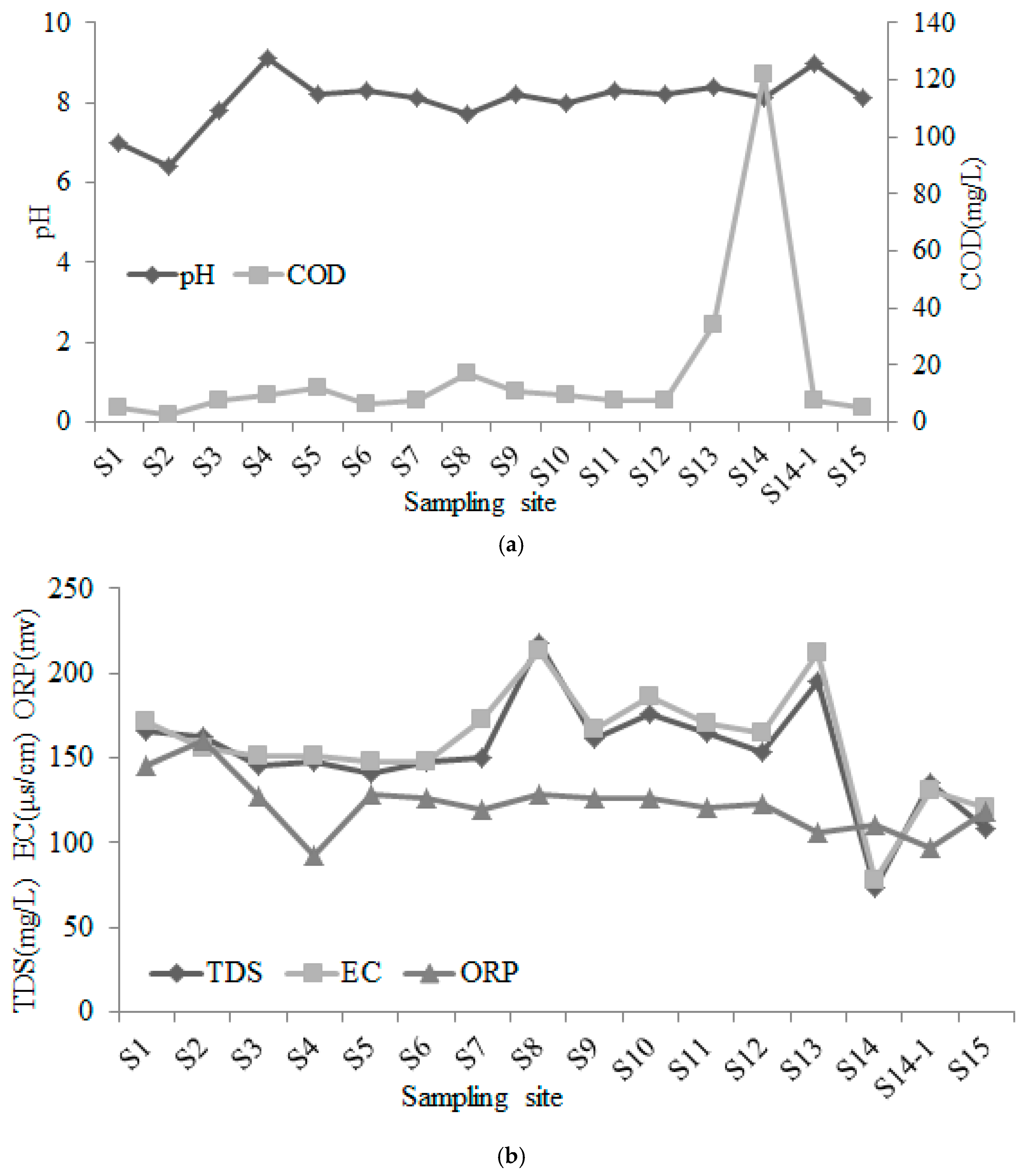
Table 2 shows the general physicochemical data statistics of all the water sampling sites, including pH, EC, temperature, TDS, ORP, and ion compositions.
The pH value is a commonly used indicator for the acidity and alkalinity of natural water quality. It is also an important factor affecting the occurrence state, concentration, and distribution of water elements. Natural water generally has a pH value of 6–9. Many substances dissolved in natural water enable it to have certain buffering properties and resist the influence of extraneous acid and alkali substances, so that the pH value of natural water can be maintained stable without significant changes. Carbonic acid, carbonate, and bicarbonate in natural water are the main acid and alkali substances, which constitute the main buffer system in natural water. The LR water samples were neutral to alkaline and had strong buffering capacity due to the influence of rock and soil characteristics in the basin. The pH values of each sampling sites changed gently, ranging from 6.40 to 9.10 with an average value of 8.06 and a standard deviation value of 0.63 in 2017. The acidity and alkalinity of the main river reach and tributaries of the LR did not change much, all appearing to be alkaline. Affected by the urban sewage and waste in Lhasa City and the geothermal development in Yangbajain town, the pH value in the main stream was on the rise after it flowed through Lhasa City (sampling site S14 and S14-1,
Figure 2a). The pH value in the LR conformed to environmental quality standards for surface water of People’s Republic of China (EQSSWPRC) (GB3838-2002). The temperature of the river samples ranged from 13.60 to 23.40 °C with an average value of 16.57 °C and a standard deviation value of 2.37 °C. The COD values had similar trend with the pH ranging from 2.43 to 121.70 mg/L with an average value of 16.88 mg/L and a standard deviation value of 27.97 mg/L, except for the sampling site S14 (121.70 mg/L) that is near the Yangbajain town (
Figure 2a). The concentrated geothermal development in the Yangbajain town was likely the main cause of this phenomenon. According to EQSSWPRC (GB3838-2002), the LR had been distinctly affected by anthropogenic activities only from the aspect of COD.
Mineralization is the total mineral content in water. It is an important index for the determination of hydrochemical composition and one of the main indexes for evaluating the suitability of irrigation water in farmland. The measurement of electric conductivity reflects the content of ions in water, which is often used to predict the total concentration or salinity of ions in water. When the hydrological, geological, and geographical conditions are basically the same, there is a correlation between the change of water electric conductivity and mineralization, which can be used to reflect the salinity of water. The fluctuation range of mineralization and electric conductivity was basically the same (
Figure 2b). Under the influence of water quantity and tributary supply along the route, the electric conductivity and mineralization of the main stream showed a decreasing trend. The TDS and EC values ranged from 73.37 to 217.55 mg/L and 77.30 to 213.00 μs/cm, respectively, with average values of 152.94 mg/L and 158.66 μs/cm, respectively and standard deviations of 31.56 mg/L and 31.92 μs/cm, respectively. The average mineralization of World Rivers is 97 mg/L while the average mineralization of the water in the main stream of the Yangtze River in the plateau is 140–180 mg/L. Therefore, the water in the LR belonged to weak to moderate mineralized water, which could be used for farmland irrigation. The mineralization in Doilungqu was slightly higher than that of the main stream and other tributaries, which may be due to the high distribution of geothermal resources in the upstream source area of the tributary. The high mineralization of this tributary was mainly caused by the geothermal water supply of various ions or the tail water discharge of the geothermal power station of upper Yangbajain town. The ORP showed a declining trend along the sampling sites, ranging from 92 to 120 mv with an average value of 122 mv and a standard deviation value of 15.89 mv, indicating that the river water presented a certain degree of oxidation.
3.2. Main Ionic Components and Hydrochemical Types
The composition of soluble substances in natural water is very complex, mainly including the crustal minerals dissolved and migrated by water in the process of rock weathering. Its chemical composition and spatial and temporal distribution are closely related to topography, climate, hydrology, biological conditions, and anthropogenic activities. Ca
2+, Mg
2+, Na
+, K
+, Cl
−, SO
42−, HCO
3−, and SO
42− are eight common ions in natural water, accounting for more than 90% of the total ions in all solutes in water. These major ions are often used to characterize the main chemical characteristics of water. The average concentrations of cations and anions followed an order of Ca
2+ > Na
+ > Mg
2+ > K
+ and HCO
3− > SO
42− > Cl
− > NO
3−, respectively (
Table 3). The proportion of Ca
2+ to total cations was larger than 60% while the proportion of HCO
3− to total anions was larger than 70%.
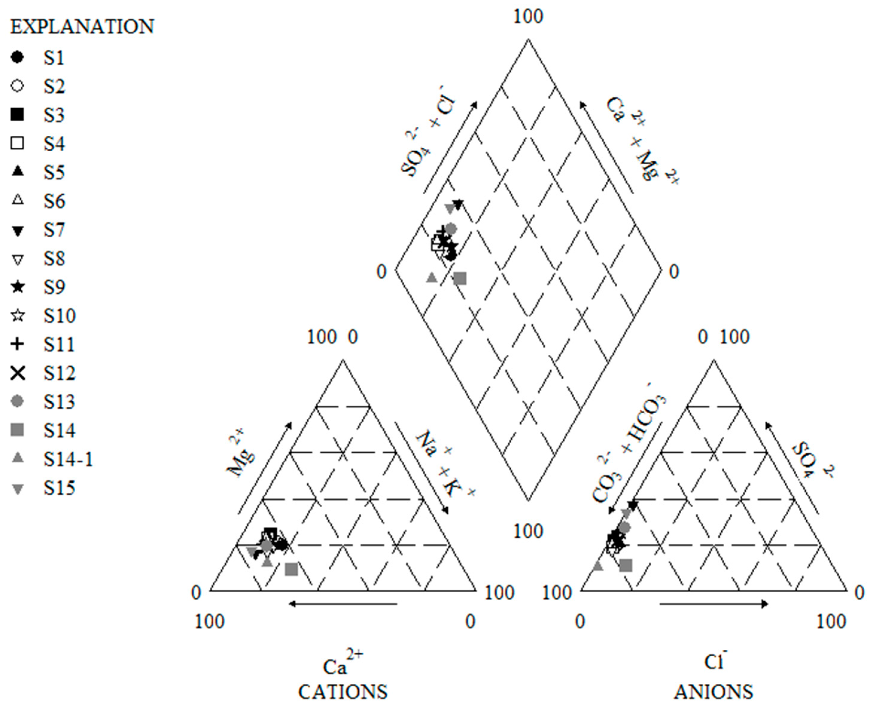
Figure 3 was the piper diagram showing the surface water samples collected from the LR. It could be seen from
Figure 3 that the major cations in the main stream of the LR were dominated by Ca
2+ (accounting for 62.57% to 79.91% of the total cations), followed by Na
+ + K
+ and Mg
2+. The major anions were HCO
3− (accounting for 67.31% to 90.69% of the total anions), followed by SO
42−. Therefore, the hydro-chemistry type of the main stream of the LR was bicarbonate.
The content of main ions in the LR did not change significantly from upstream to downstream. According to the measured NO
3− values (
Table 3), these values were better than EQSSWPRC (GB3838-2002) (≤10 mg/L). However, the NO
3− content was slightly higher in the sampling sites around Lhasa City and in the tributary of Laqu, possibly due to the impact of urban household garbage and grazing. There are many villages along the river, mainly engaged in agriculture and animal husbandry. They mainly use surface water for irrigation and drinking of people and animals. Although the LR is not a source of surface water for Lhasa City, the used groundwater is also extracted along the LR banks. If the NO
3− content is large than 3 mg/L, it will pose a certain threat to the drinking water.
The determination of coefficient of correlation helps to evaluate the existence and extent of relationship between two variables. Association of some elements may lead directly to the interpretation of the likely sources of the elements. Good positive correlations between Ca
2+ and HCO
3− (0.86), Ca
2+ and SO
42− (0.75), Ca
2+ and Mg
2+, (0.75) and Mg
2+ and HCO
3− (0.78), and positive correlations of Ca
2+-Na
+ (0.46), Mg
2+-SO
42− (0.61), and Mg
2+-Na
+ (0.38) in the LR (
Table 4) supported that the main source of these ions was dissolution of carbonates and gypsum in the river, and the dominance of the dissolution of mineral and subsequent ion-exchange processes in the river. It implied that the same source could be inferred for these elements that have strong relationships.
3.3. Trace Element Chemistry
The content of various trace elements in the main stream of the LR was generally low and the difference was great (
Table 5). Here, a total of seven trace elements were discussed in this section. The contents of As, Cd, and Mn in the whole basin of the LR was relatively stable but increased sharply after passing through Lhasa City. The content of these three elements in the lower reaches of Lhasa City increased regularly. It could be seen that the municipal waste and domestic wastewater have had a certain impact on the LRB. The element contents near the inflow point of the Yarlung Zangbo River decreased, mainly due to the dilution effect of runoff.
The element Mn content in the downstream of Laqu and Doilungqu, which have higher turbidity, was higher than other sampling points. This may be due to the agitation and release of the metallic elements deposited in the sediment of the shallow surrounding waters caused by the construction of Poindo hydro-junction and the livestock grazing in the farming and stockbreeding areas, making the turbidity and metallic element contents increase in these sampling areas. The tailings residue from mining activities and heavy-metal pollution from agricultural irrigation may be the reasons for the pollution of the LR. The As content was obviously high in the LR, which was related to the As-rich shale widely distributed in Tibet and geothermal activities.
The contents of Cu and Zn were obviously higher in sampling sites S9, S10, and S11 than in other sites. This may be caused by the mining activities around these sites. There are large copper polymetallic deposits near these three sampling sites. However, this phenomenon had no significant effect on the main stream with relatively large water volume. The dissolved phase data at sampling point S12 lying downstream of the main stream showed that the influence of mining activities on water chemistry in the region was slowed down by the dilution of main stream. The content of Fe was obviously higher near the Yangbajain town (111 μg/L in sampling site S14 and 16 μg/L in site S14-1). This also may be due to the high distribution of geothermal resources in Yangbajain town.
The Sr contents in all sampling sites were remarkably higher than other elements, ranging from 35.10 to 147 μg/L with an average value of 88.89 μg/L and a standard deviation of 23.48 μg/L. Modern medical studies have shown that strontium is closely related to human health. It is an essential microelement for human physiological functions, which can play a role in strengthening bones and teeth, and is conducive to maintaining normal cardiovascular functions as well as the excitability of nerves and muscles, so as to reduce the death rate of cardiovascular diseases. However, if the level of strontium in the water is too high, long-term drinking will lead to the accumulation of strontium in the body, and also cause some pathological changes, which is not good for human health.
Table 6 shows the correlation coefficients between heavy metal, pH, and salinity in the LR. It could be seen that there was a significant positive correlation between the contents of Cd and Cu (0.52) and Cd and Mn (0.64), which indicated that the pollution of Cd, Cu, and Mn had a certain degree of homology. There was a significant negative correlation between the contents of Fe and Sr (−0.63) and TDS and the content of Fe (−0.67), which indicated that the sources of Fe and Sr were different. Research has shown that acidic wastewater can lead to the activation and migration of heavy-metal elements in solid waste. However, the water in the LR was alkaline, which may be the reason why there was no significant correlation between the contents of seven heavy metals and pH value. There were no significant correlations among As, Mn, Fe, and Cu, indicating that the pollution was multi-source. The contents of Cd and As in the LR were lower than the limit value of class I of EQSSWPRC (GB3838-2002), showing that the contents of these two heavy metals are the natural background values. The correlation coefficient between TDS and the content of Sr (0.83) was very high, which indicated that Sr in the LR mainly came from the rocks dissolved in the river water. Different rocks contain different amounts of strontium. Precipitation falls on the ground and flows through different rocks, resulting in different levels of strontium and isotope ratios in surface water [
25,
26]. As strontium and calcium have similar geochemical properties, strontium is often used to determine the weathering rate of calcium-containing minerals and to trace the sources of calcium in groundwater.
Note that this study did not involve the suspended particulate matter and sediment in rivers. Most heavy-metal elements would be transported by suspension or adsorbed on the surface of suspended particles and transported to the downstream area. Significant chemical substances amounts would therefore be available in suspended matter and sediment, making it an “invisible pollutant”. Below the plateaus, the lower reaches of the river are intensive agricultural production areas. Once the pollutant enters the food chain through biological enrichment, it will seriously endanger the environmental health.
4. Discussions and Implications
The controlling factors that affect the hydrogeochemical characteristics of the LR can be divided into natural and anthropogenic ones. The former includes climate change (precipitation, temperature, and evapotranspiration), hydrological characteristics, soil characteristics, biological organism, and rock weathering, while the latter includes water conservancy facilities construction, mining activities, and urban economic development.
4.1. Natural Factors
Climatic factors are the most important influencing factors of solute components in water. Under different climatic conditions, differences in precipitation, temperature, and evapotranspiration lead to differences in solute components in the river basin. The LRB relies mainly on precipitation for river water recharge. Precipitation is mostly concentrated in summer from June to September, with little rain in other seasons. The precipitation directly affects the ion concentrations in the river. In the rainy season, the precipitation is large and concentrated with large runoff, which results in small solute concentration in the river. The LRB affected by global climate warming in nearly 50 years has shown significant change with annual average temperature rise of 0.5 °C. High temperatures have led to increased evaporation, slow degradation of the glacier, and the decrease of the frozen soil area in the LRB, which increased the solute of water resources in the Qinghai-Tibet plateau and decreased the water quality.
Hydrological characteristics mainly include runoff, flood season, sediment concentration, and ice age. Runoff volume in the river basin, time period of flood season, sediment concentration, and ice age all have great influence on hydrochemical components. Usually in flood season, the river flows faster and has a short contact time with the river bed; hence, the dissolved solids content in the water is relatively low. On the contrary, the flow velocity is slow, and the long contact time between the water and the river bed will increase the dissolved solids content in the water.
When water permeates the soil, the river takes away the soluble materials in the soil and increases the solute concentration in the water. The finer the soil texture is, the smaller the dissolved substance is when water comes into contact with the soil. At the same time, the water may have ion exchange reaction with soil, which will also affect the water composition.
The effects of biological organisms on the composition of natural water solutes include the decomposition of animal wastes and residues into water bodies, the decomposition of organic matter in water bodies promoted by the photosynthesis of aquatic plants, and the active absorption or adsorption of some ions by animals and plants.
The solute components in river water are affected by the weathering of rocks, mainly involving three types (silicate rock, carbonate rock, and evaporate rock). The weathering of these three rock types provides an initial source of water solutes. The landform of the LRB is a river terrace of first or second grade, and the topography is steep to fracture. The tectonic components are mainly the products of the Yanshan mountain movement, and the sediments in the river basin are mainly sandy and gravel layers. The surface weathering has an important effect on the solute composition in the river water.
4.2. Anthropogenic Factors
A large number of water conservancy facilities have been built in the LRB, including Zhikong hydropower station and Poindo hydro-junction, which are the most important and famous ones. They play a positive role in promoting the economic development of the river basin, but the superimposed ecological impact brought by them cannot be underestimated. The impact of the construction and use of the water conservancy project on the river ecology is mainly reflected in the river species spread downstream or upstream affected by the river cutoff. The river species lose the natural living environment and reduce the biodiversity. Meanwhile, water degradation and self- purification capacity are also affected.
The LRB is rich in mineral resources. The development of mining industry has been regarded as a new economic development point, which is in line with the actual economic development direction of the TAR. However, with the development of mining activities, the impact on Tibet’s ecological environment is inevitable. With the use of the mine, the tailings contain many kinds of valuable metals, which cause pollution when they enter the water and increase the heavy-metal content in river water.
With the implementation of the western development plan, industries such as industry, agriculture, transportation, and energy in the Qinghai-Tibet plateau have been developing rapidly. The population growth and non-point source pollution have brought many adverse effects on the water environment of the LRB. Lhasa City is an area in the LRB where the population is relatively concentrated. As the urban industry is underdeveloped, the impact on LR environment is mainly caused by the excessive use of fertilizers and pesticides in agricultural production. The non-point source pollution in the LRB is not obvious compared with other areas. However, with the continuous input of national policies, the economic and social development is bound to be accelerated. As a major farming area in Tibet, the environmental impact of economic development will be aggravated in the basin.
4.3. Implications
At present, the construction and use of Zhikong hydropower station and Poindo hydro-junction have brought ecological impact on the lower reaches of the LRB. Therefore, consideration should be given to the integrity of river basin flow in the design approval of planned water conservancy facilities, and the used water conservancy facilities should meet the demand of water supply, flood control, irrigation, and power generation within the region, while minimizing the impact on the river basin ecology. Therefore, the role of ecological scheduling appears particularly important. The ecological scheduling can balance the functions of existing water conservancy facilities and the downstream ecology, and control the flow to maintain the original ecological environment of the river as much as possible without affecting the economic development and disaster prevention objectives within the river basin, so as to ensure the adaptability of water biological species and ensure the ecological health of the river.
It is necessary and important to establish standards for sewage and wastewater discharge in the LRB, classify and treat the sewage discharged by residents and enterprises in the basin, and strictly supervise the sewage discharged by mining plants that may affect the water environment of the LRB, so that it can meet the national emission standards.
In view of all kinds of enterprises of the main industrial types (small grain and oil processing, power generation, construction, mining, etc.) in the LRB, it is crucial to vigorously promote the new technology, abandon high pollution and low efficiency traditional processing and manufacturing means, classify and treat the waste water and slag disposal, develop waste recycling, strengthen the government policy support, reward to promote the enterprise with a more rapid development of new technology, and so on. The government should severely punish those enterprises that fail to meet the national emission policy and set a deadline for rectification. If the enterprises fail to meet the standards and are seriously backward in technology and equipment, the government will close them down.

 ,
, 


