Review

Impact of Eastern Redcedar Proliferation on Water Resources in the Great Plains USA—Current State of Knowledge

1
Department of Natural Resource Ecology and Management, Oklahoma State University, Stillwater, OK 74078, USA
2
Department of Agronomy and Horticulture, University of Nebraska, Lincoln, NE 68506, USA
3
Biological Systems Engineering Department, University of Nebraska, Lincoln, NE 68506, USA
4
Grazinglands Research Laboratory, USDA, El Reno, OK 73036, USA
5
Red River Research Station, Louisiana State University Agricultural Center, Bossier, LA 71112, USA
*
Author to whom correspondence should be addressed.
Water 2018, 10(12), 1768; https://doi.org/10.3390/w10121768
Submission received: 13 November 2018 / Revised: 21 November 2018 / Accepted: 28 November 2018 / Published: 1 December 2018
(This article belongs to the Special Issue Ecohydrology of Woodlands and Savannas)

Abstract

:
In the Great Plains of the central United States, water resources for human and aquatic life rely primarily on surface runoff and local recharge from rangelands that are under rapid transformation to woodland by the encroachment of Eastern redcedar (redcedar; Juniperus virginiana) trees. In this synthesis, the current understanding and impact of redcedar encroachment on the water budget and water resources available for non-ecosystem use are reviewed. Existing studies concluded that the conversion from herbaceous-dominated rangeland to redcedar woodland increases precipitation loss to canopy interception and vegetation transpiration. The decrease of soil moisture, particularly for the subsurface soil layer, is widely documented. The depletion of soil moisture is directly related to the observed decrease in surface runoff, and the potential of deep recharge for redcedar encroached watersheds. Model simulations suggest that complete conversion of the rangelands to redcedar woodland at the watershed and basin scale in the South-central Great Plains would lead to reduced streamflow throughout the year, with the reductions of streamflow between 20 to 40% depending on the aridity of the climate of the watershed. Recommended topics for future studies include: (i) The spatial dynamics of redcedar proliferation and its impact on water budget across a regional hydrologic network; (ii) the temporal dynamics of precipitation interception by the herbaceous canopy; (iii) the impact of redcedar infilling into deciduous forests such as the Cross Timbers and its impact on water budget and water availability for non-ecosystem use; (iv) land surface and climate interaction and cross-scale hydrological modeling and forecasting; (v) impact of redcedar encroachment on sediment production and water quality; and (vi) assessment and efficacy of different redcedar control measures in restoring hydrological functions of watershed.

1. Introduction

Surface runoff and groundwater recharge from rangeland ecosystems in the Great Plains of the United States is, in general, scarce and highly variable [1,2]. It is a formidable challenge to meet the increasing demands on water resources by agriculture and energy production, as well as the increasing human population, while also maintaining ecological flow for aquatic ecosystems. Additionally, global warming and the ongoing land use and land cover change may exacerbate this challenge. Of particular relevance and a current concern in land management are ecological regime shifts due to the rapid proliferation of eastern redcedar (Juniperus virginiana L.; herein referred to as redcedar) into rangelands and its potential impact on hydrological processes, runoff regime, and groundwater recharge potential.
The Great Plains is a transition region between relatively moist eastern deciduous forest and arid desert to the West. Reductions in the number and frequency of fires in the region and minimal active grassland management are two key factors leading to woody plant encroachment into grassland areas [3], as well as the densification and mesophication of forests [4]. Over the past century, redcedar has increased and become dominant at many rangeland sites in the Central Great Plains where it was historically absent. As encroachment increases, redcedar displaces native flora and fauna [5,6], thus reducing biodiversity [7] and habitat quality of important wildlife species. The encroachment also severely reduces livestock production, which is the primary regional land use and the critical economic activity in the region [8].
Interests and concern regarding redcedar encroachment are not recent. A chronological timeline (Figure 1) of research on redcedar encroachment illustrates the evolution of interests and concerns from economic, then to ecological, and finally to water resources. The concerns of its impact on water resources are most recently reflected by several studies conducted in the rolling plains of Oklahoma and the Sand Hills of Nebraska. In this synthesis, we will discuss the change of hydrological processes, and therefore, the “rebalancing” of the water budget associated with the land surface transformation from grassland to redcedar woodland for selected sites in the Great Plains, USA. We will discuss the alteration of critical hydrological processes and individual components of the water cycle after redcedar encroachment. The discussion is based on our research of over a decade as well as research findings reported in the literature. Our focus will be on the impacts of encroachment on runoff (Q) and groundwater recharge (G), two small and usually ignored components in the hydrologic analysis of semiarid and sub-humid watersheds. We will conclude by positing research challenges and opportunities based on the literature synthesis, which could continue to improve our understanding of these important ecological processes and ultimately help curtail the progression of redcedar and sustain the hydrological function and water resources in the vast rangeland in the Great Plains of USA.

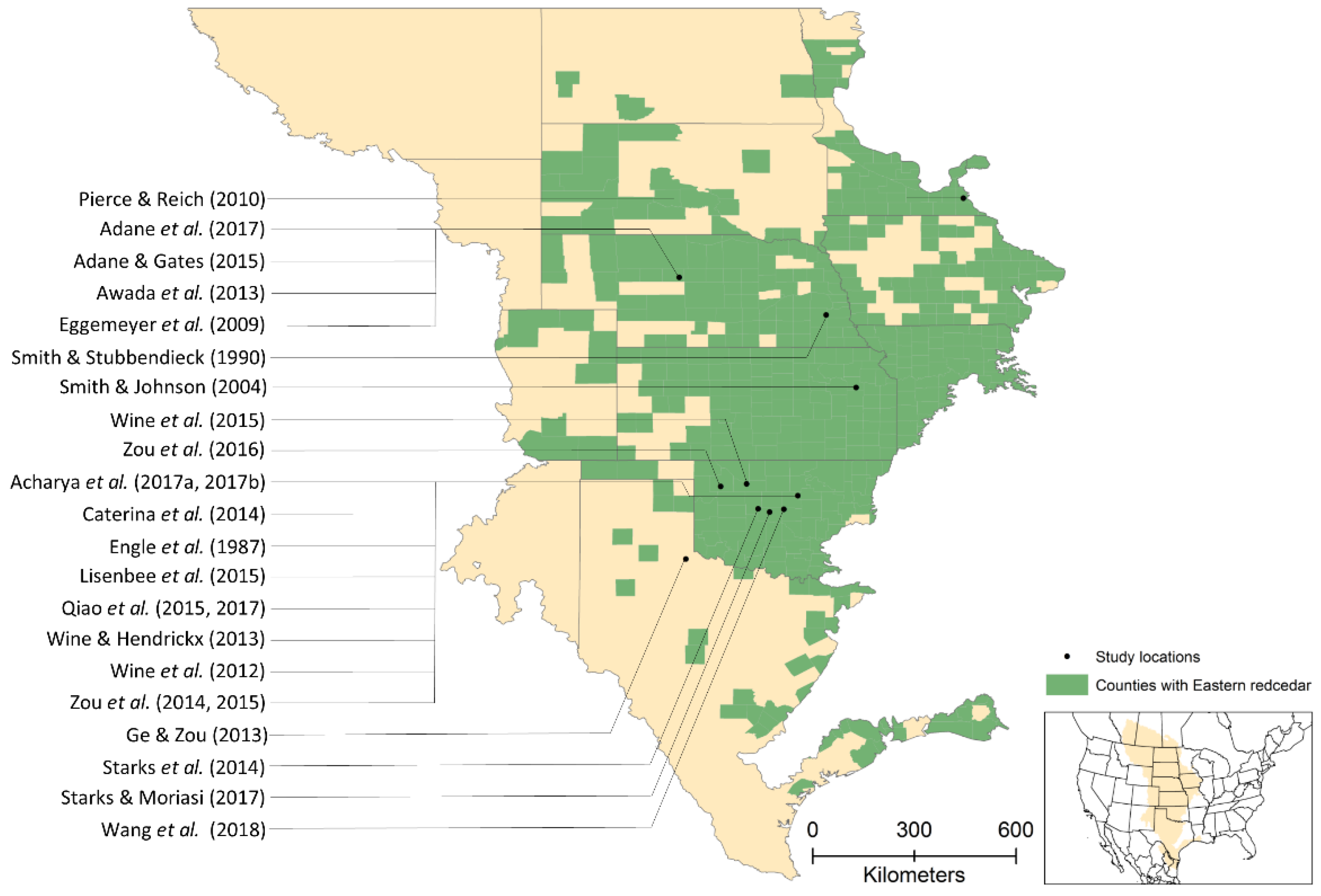
2. Redcedar and Its Proliferation

2.1. Distribution and Dynamics

Redcedar is a native coniferous evergreen species. Its natural distribution spans from the East of the Rockies throughout the East and lower and upper Midwest of the USA [9]. Within the Great Plains, redcedar is found throughout the eastern and central portions (Figure 2). McKinley et al. [10] indicated that about seven million hectares of grasslands in the portion of the Great Plains had been encroached upon by redcedar. Redcedar can survive in shallow and dry soils and is moderately tolerant of alkaline soils. Recently, Wang et al. [11] showed that, for ten counties in central Oklahoma, redcedar was expanding its encroachment into grasslands at a rate of about 8% annually. In a companion study, Wang et al. [12] concluded that redcedar abundance has increased since 1984 at an annual rate of 40 km2 year−1 and that redcedar patches detected in 2010 were mainly distributed in sandy and loamy soils that had a low potential for storing water in the upper soil layers. In Nebraska, approximately 8100 ha of non-forested lands were converted to redcedar forest annually [13]. Recent studies are documenting the expansion of redcedar into regions that were previously considered to be resistant to encroachment (e.g., Nebraska Sandhills [14,15]).
The causes of expansion of redcedar in the tallgrass prairie have been widely studied and primarily attributed to anthropogenic-induced changes such as the reduction of the fire frequency and intensity and the increase of grazing intensity [3,16]. A more recent study analyzing the time series of redcedar composition also links the initial establishment of redcedar with episodic events such as protracted drought [17]. The rates of redcedar encroachment in the Central Great Plains is twice that occurring in the Southern Great Plains and almost four times that in other more arid regions in North American rangelands [18].

2.2. Morphological and Physiological Traits of Redcedar

Redcedar is an evergreen tree with a pyramidal form when grown in the open. The foliage of young trees is usually sharp and spikey, while the foliage of older trees is scaly, overlapping, and branched [19]. A mature tree grows to a height of 10–12 m, and the branches may spread four to five m in diameter.
Redcedar was initially reported to grow well in open field habitats as a sun-adapted, drought-resistant species with a long growing season, which includes winter, but excluded from mature forests because it is shade-intolerant [20]. However, it was reported to be a regular component of the understory in mature oak-hickory forests in central Missouri due to it being an evergreen conifer and able to maintain a positive CO2 balance throughout much of the year in a deciduous forest [21]. In study locations within North-central Oklahoma, redcedar encroaching into the mid story of the oak-dominated Cross Timbers now composes 21% of the canopy cover [22]. The mechanism of redcedar to live both in open and understory settings is not well understood.

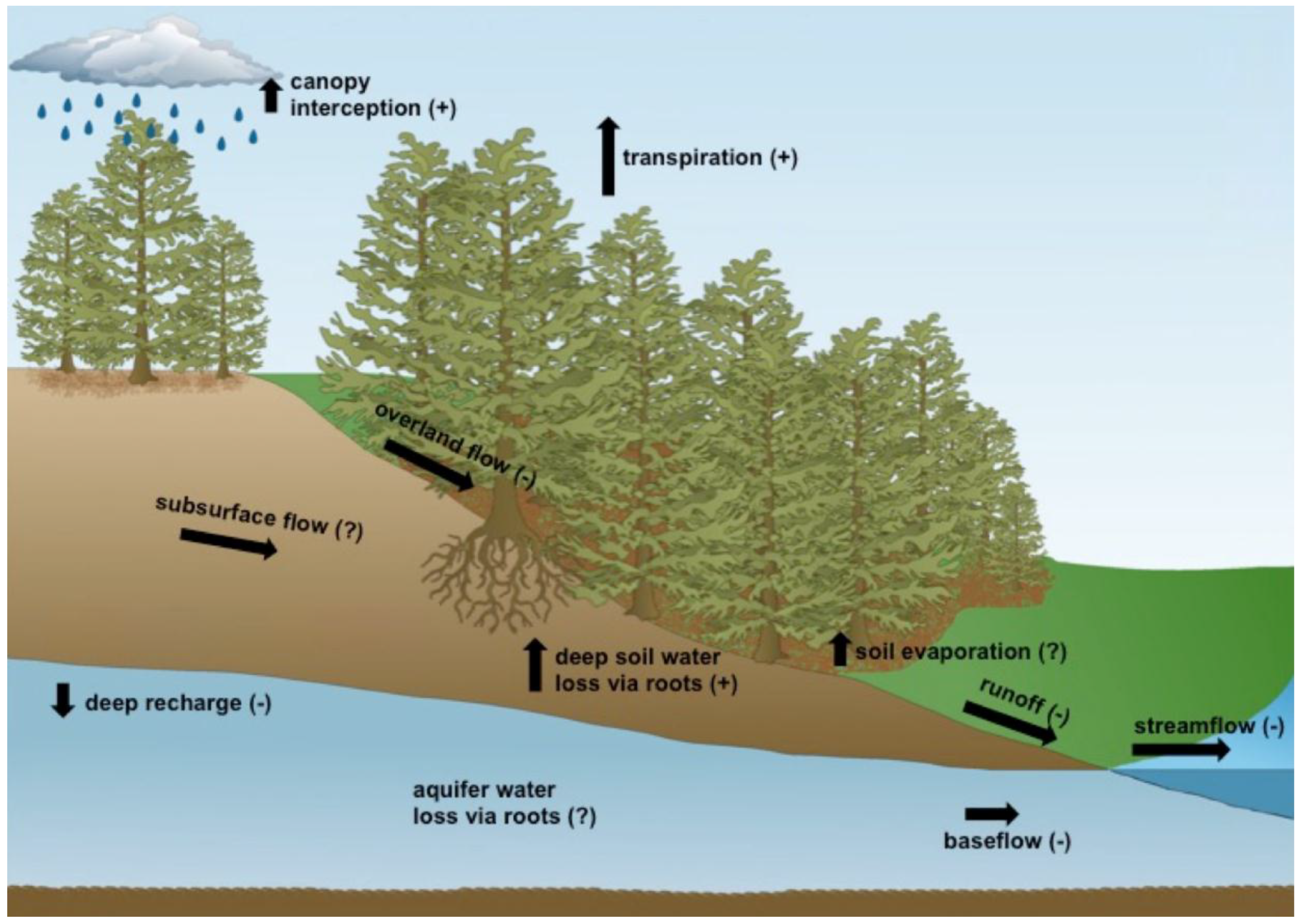
3. Alteration and Rebalance of Water Budget after Redcedar Encroachment

For a watershed without inflow, the available water resource for non-ecosystem use come from runoff (Q) and groundwater (G) and is represented by the following water balance equation:
Q + G = P − ET − ∆S
From the water balance perspective, Q and G are the residuals of the influx of precipitation (P) and the outflux of evapotranspiration (ET), assuming the net change of soil water storage (∆S) is negligible for the concerned period. ET can be further partitioned into evaporation from the canopy (Ec), litter layer (El), and soil (Es), and transpiration (T) by vegetation. Emergence, development, and the establishment of an evergreen redcedar canopy in herbaceous dominated grassland will substantially transform the canopy structure, the litter layer dynamics, and the bare soil affecting Ec, El, and Es. Changes in the rooting structure and the depth, and the phenology of water uptake will change the spatial and temporal dynamics of soil water storage (∆S) and transpiration (T). In principle, changes in the ET components have to be rebalanced by either runoff or groundwater, or both under the same precipitation input (Figure 3).

3.1. Evapotranspiration

Evapotranspiration is usually the largest water flux from dryland ecosystems, accounting for over 90–95% of precipitation [2,46]. The reported ET for a tallgrass prairie ranged from 663 mm year−1 to 813 mm year−1 depending on the location and climate condition [47,48] and accounted for 80–90% of annual precipitation.
Direct ET measurements of redcedar encroached sites are limited. The patchy nature of redcedar encroachment limits the application of the eddy covariance (EC) technique due to the large fetch requirement. In a study that did use the EC technique, Duesterhaus [47] compared the annual ET of an even-aged (of about 50 years old) redcedar site and an adjacent prairie site in Kansas with an average annual precipitation of 880 mm. Annual total ET for the woodland site was 885 mm compared to 813 mm from the prairie site, a difference of 8%. This indicates that a mature redcedar site is capable of evapotranspiring all precipitation for a year with average precipitation in that site. In a year of below-average precipitation (677 mm), separate measurement of interception and transpiration suggested that all precipitation was either intercepted or transpired and exited back to the atmosphere in a stand with complete canopy closure of redcedar trees in a site at the Central Great Plains [23]. Hydrus 1-D model simulations over a 13 year period from 2000–2012 using climate data (precipitation, wind speed, air temperature, dew point temperature, atmospheric pressure, and solar radiation) from a site in Oklahoma showed that, on average, ET accounts for 45% of the reference ET (ETo), but over 95% of the precipitation [24]. ET simulation using the Soil & Water Assessment Tool (SWAT) suggested that the ET was higher under the redcedar cover than under tallgrass prairie cover, and that the difference increases in a wetter basin or under higher precipitation [25].
These studies, using different approaches and being conducted at multiple spatial scales, mostly agree that encroachment of redcedar increases total ET loss. The increase in ET usually accounts for only a few percent of the total precipitation. Considering the average runoff coefficient, the percentage of precipitation that will become runoff, for this region is low, this level of increase in ET will substantially reduce, and ultimately eliminate runoff or groundwater recharge, or likely both [26].

3.1.1. Transpiration

Redcedar is commonly believed to be a “water guzzler” meaning active and aggressive water use. The water use of redcedars of different sizes and canopy forms was measured using sap flow techniques in the Sand Hills of Nebraska [39] and central Oklahoma [23,27]. Redcedar was found to transpire as long as the air temperature exceeded −3 °C [23], which allows the redcedar to transpire most days of the year, even when grasses and deciduous trees are dormant. The amount of water transpired by a given redcedar tree is a function of tree size, atmospheric conditions, and availability of soil water [23]. In a study by Caterina et al. [23], the overall daily average water use was about 24 L per tree, but the largest trees transpired 50–60 L day−1, with one tree using an extremely high value of 161 L day−1. Redcedars in low density stands were found to use more water than redcedars with a similar diameter, but located in denser stands [23,27]. However, there was no significant difference in stand-level water use when expressed on a canopy area basis [23].
Stand level transpiration averaged 413 mm year−1 in Nebraska in a year with above-average precipitation [39]. A later study conducted in central Oklahoma in a hot and drought year reported a similar value of stand-level transpiration (431 mm) [23]. Direct comparison of stand-level transpiration between grassland and redcedar is usually unavailable. For grassland, transpiration was mostly measured together with evaporation as evapotranspiration based on energy balance, remote sensing, or eddy flux techniques [28]. Partitioning evapotranspiration into transpiration and evaporation remains a formidable challenge in the tallgrass prairie [49].
The sapflow density of redcedar, the water flux per unit sapwood area, is relatively low among the associated sub-canopy species in a moist pine forest [50]. A global synthesis showed that the daily water use of a mature tree for most tree species ranges from 10 to 200 L day−1 [51]. Comparatively, redcedar has a relatively low daily water usage among tree species, ranging from 1.0 to 65 L [23]. Water guzzler might not be a correct characterization of redcedar regarding its active water extraction from soil.

3.1.2. Evaporation from Vegetation (Ec and El)

Precipitation capture by canopy interception and subsequent evaporation is an intensively studied process in forest hydrology. After multiple decades, the research community has generally embraced the idea that the ratio of precipitation lost to forest canopy interception is highly variable depending on climate and tree species.
A few studies have directly quantified the rainfall loss to redcedar trees in the tallgrass prairie where snow input is insignificant [27,29,47]. These studies concluded that a relatively high proportion of rainfall (over 35%) fails to reach the soil surface. The ratio of this loss differs significantly among different grass species [52,53]. A few studies showed that the rainfall loss to the canopy of tallgrass prairie was quite substantial, ranging from 25% to 60% of bulk rainfall [54,55]. These ratios are generally much higher than the ratios estimated for Southern pine plantations under similar climatic regions [56] and typical forest temperature in colder climates [57].
The canopy structure of redcedar is closely associated with its growth form. A redcedar tree growing in open space differs greatly from that in the closed canopy in the shape and foliage density. Additionally, precipitation may approach the entire canopy profile, from multiple directions and angles, for a redcedar tree in the open. That difference increases the spatial heterogeneity in addition to the temporal variability of canopy interception. The low rainfall input angles affect the redistribution between throughfall and stemflow through the branch funneling. Small redcedar trees growing in the open were reported to have one of the highest funneling ratios, the ratio of rainfall amount delivered to the base of the tree to the rainfall that would have reached the ground should the tree were not present, for woody plants [29], facilitating stemflow and channeling rainfall towards the litter layer and soil surface.
The litter layer of scale-like redcedar foliage usually forms a uniform, spongy layer up to a few centimeters in depth if undisturbed. For example, with a 3 cm litter layer, a substantial amount of throughfall, up to 8% of precipitation, can be retained before reaching the mineral soil [58].
Considering the direct impact of climate and precipitation regime on interception rate, it holds great value to directly compare rainfall loss between redcedar and grassland to interpret its relative impact on water cycle under the same climate condition. A full year study accounting for canopy interception of every single rainfall event for open-grown and closed grown redcedar trees and intact tallgrass prairie (not grazed) was conducted during a dry and hot year in Payne County, OK of the central Great Plains, USA [29]. Results showed that redcedar trees had relatively high canopy storage capacity, and the interception ratio was similar for open or closed grown trees based on the canopy coverage. Except for a notable increase in interception ratio during the hot summer, the monthly rainfall interception ratios for redcedar trees were quite constant. In contrast, the monthly rainfall interception ratios for tallgrass prairie were highly variable and increased with the grass canopy development and peaked at its senescence. The accumulated loss of precipitation to the tallgrass prairie was significantly lower than that to the redcedar woodland during the earlier growing season and the full growing season. The ratios of precipitation loss to senescent tallgrass prairie were high and highly variable. The annual canopy interception ratio of intact tallgrass prairie was not statistically different from well-developed redcedar woodland.

3.1.3. Evaporation from Soil

Evaporation from bare soil has not been widely considered in the relatively well-vegetated tallgrass prairie system. This is likely due to the relative directness of quantifying the grassland ET as a whole using an EC system, which avoids the need to quantify E and T separately. If the purpose is to estimate the impact of redcedar encroachment on the availability of water resources, then quantification of ET is more direct and relevant. Soil evaporation, if desired, could be back-calculated through an ET partitioning procedure using isotopic techniques [49].

3.2. Soil Water

Engle et al. [30] were among the first to show that, in the loamy soil-dominated rolling plains of central Oklahoma, soil moisture underneath a redcedar canopy was much lower than that in the adjacent grassland. Smith and Stubbendieck [40] reported that soil moisture underneath redcedar canopy was lower than for the open prairie in coarse textured soils in Nebraska. A moderate decrease in soil moisture under redcedar canopy was reported during the non-growing season when grasses were senescent [41]. Using solute mass balance methods, Adan and Gates [42] found that soil moisture averaged 2.5% under redcedar compared to grasslands with an average of 9.7%. Pierce and Reich [43] conducted a study investigating the influence of redcedar encroachment on a remnant prairie on a slope with shallow soils in Minnesota and reported an increase in soil moisture under redcedar canopy and attributed this increase after capture of overland flow by the soil under the redcedar trees perhaps due to greater infiltration rates. Similarly, spatial heterogeneity of soil moisture pattern associated with the presence or absence of individual tree canopy was reported to be caused by the hydrophobicity behavior induced by redcedar litter properties [31]. As a result, time, topographic location, and climate may all affect the soil moisture responses to redcedar encroachment.
Depletion of soil moisture after redcedar encroachment is not consistent throughout the soil profile. Acharya et al. [32] observed more depletion of deep soil water than from the surface soil. It is widely believed that junipers are capable of developing deeper rooting systems than most coexisting grass species and are physically capable of accessing water at depths unavailable to grasses, as suggested for juniper species in general [59]. Physiologically, redcedar exhibits flexibility by exploiting water from deeper soil layers during dry periods and from the upper soil when shallow water is available [44]. Phenologically and climatically, the carbon assimilation transpiration of the evergreen foliage of redcedar in a generally warm and dry autumn and winter in the central and Southern Great Plains could drive the depletion of deep soil moisture and result in the reduction of coherence or correlation between precipitation and deep soil moisture [60]. Depletion of the deep soil profile is associated with the reduced groundwater recharge potential at the local scale [32].
Zou et al. [33] conducted a multi-year study on three grassland micro-catchments and four adjacent redcedar dominated micro-catchments near Stillwater, Oklahoma. Results from the study indicated that soil water storage on the encroached catchments were generally lower than that on the grassland catchment, especially preceding the peak rainfall and runoff season in the spring and early summer, leading to reduced potential for surface runoff, in particularly, the saturated overland flow [61] and interflow components [33].

3.3. Impact on Water Resources Available for Non-Ecosystem Use

A large portion of water resources in the Great Plains exists in the forms of surface storage such as reservoirs and ponds, or subsurface storage such as aquifers. Depending on the location, the relative importance of these two forms of water resources to society is different and could be differently affected by redcedar proliferation.
The majority of surface water storage in the semi-arid and sub-humid region is replenished with storm flow dominated by surface runoff. Natural runoff from rangeland is intermittent and usually ranges from 25–125 mm in depth annually for the study region [33,62,63]. Further reduction of the runoff from the rangeland would quickly translate to water stress for an aquatic ecosystem and affect many municipal water supplies.

3.3.1. Surface Runoff

Less runoff was observed for upland grassland watersheds heavily encroached by redcedar as compared to upland native prairie watersheds in the rolling hills of north-central Oklahoma [33,34]. For years with average precipitation, the annual runoff coefficients for grassland watersheds in this study were approximately 0.1, and this ratio was observed to reduce to approximately 0.02 for the redcedar woodland watersheds [33]—an 80% reduction. This reduction was associated with a reduction of both surface and subsurface flows, and the magnitude of reduction depended on annual precipitation [34]. No or negligible runoff was observed from the redcedar watershed during drought years [35].
Wine and Hendrickx [24] used Hydrus 1D [64] to simulate the change in water balance after redcedar encroachment into the tallgrass prairie. They reported that runoff only occurred in five of the 13 years from 2000–2012 with a two-thirds reduction in deep drainage. Modeling simulations were conducted to understand the impact of redcedar encroachment on the water budget in the Cimarron River basin [25] and North Canadian River basin [36] of Oklahoma. Under the climate conditions of the period 1988–2009, complete conversion of the rangelands in the Cimarron River basin to redcedar woodlands would lead to (1) reduced streamflow throughout the year, with the largest reduction in April and May, and (2) reductions of up to 40% in annual streamflow for the drier, upper portion of the basin, and approximately 20% reduction for the entire basin [29]. This similar process in the North Canadian River basin would result in a reduction in stream discharge equal 112% of current municipal water demand and 89% of the projected 2060 demand of Oklahoma City [36]. A more realistic conversion of 20% of grassland of North Canadian River basin to redcedar would reduce stream discharge by an amount of water equivalent to ≈27% of the current water demand, or ≈21% of the projected 2060 demand [36].

3.3.2. Subsurface Flow and Groundwater Recharge

Redcedar encroachment affects deep soil moisture dynamics, subsurface flows (see Reference [34] and groundwater recharge [24]). These processes are highly related to the alteration of infiltration capacity, soil water, rooting interaction, and the water percolation pathway.
Infiltration rate and capacity is the fundamental process partitioning precipitation to the surface and subsurface pathways. The initial and steady-state infiltration rates under the redcedar canopy were observed to be nearly triple that of the grassland catchment and were intermediate in the inter canopy spaces within the encroached catchment [33]. The increased infiltration capacity is spatially dependent due to the existence of interspaces, which are a unique difference between encroached, sparsely covered landscape, and traditional forest. With the reduction in grazing intensity, the infiltration capacity increases with encroachment. The increase in infiltration capacity has two likely causes: Decrease in soil bulk density associated with a reduction in compaction and increase in soil organic matter.
Increased infiltration and potential for recharge was reported with afforestation in semi-arid agroecosystems [65]. An increase in infiltration after redcedar encroachment would promote downward percolation of soil water, theoretically enhancing deep recharge and groundwater recharge, if water is available. However, the existing evidence from the entral and North-central Great Plains point in the opposite direction, and a detailed review of woody plant encroachment on groundwater is available from a recent review by Acharya et al. [66]. In general, the groundwater recharge in an upland location in the rangeland is small. There are three lines of evidence suggesting that localized groundwater recharge reduces after redcedar encroachment into a moderately grazed grassland in the central Great Plains. Simulation using 1-D Hydrus gave a recharge average of 30 mm under grass, but only 11 mm under redcedar [24]. This estimate was further adjusted down to 9.0 mm year−1 in tallgrass prairie and 0.3 mm year−1 in the encroached site based on the chloride mass balance method [37]). Electrical imaging techniques detected reduced downward migration of soil moisture under redcedar encroached site compared with grassland and oak stands [32]. Similar results were found in situ in the Nebraska Sandhills where recharge in the native grassland was measured at 27 mm year−1 compared to 4 mm year−1 in the redcedar forest, and a reduction of 85% [42].
Delayed flow was observed during wetter periods for upland grassland micro-catchments, but rarely in the paired redcedar encroached catchments in the South-central Great Plains [33]. This extended flow in the grassland may be connected with a perched aquifer. This is likely because the interflow on these small upland catchments only exists when excess soil water is released as subsurface flow, which only occurs when soil water contents are above field capacity and a perched water table forms. Soil water content on the encroached catchment was rarely high enough to generate a perched water table during the period of the project [58,66]. The level of the perched water table fluctuated between 1.2 to 2.6 m under the grassland site, which was higher than the water level under the juniper-encroached site that fluctuated between 2.7 and 3.0 m during our study period [32].
Conversion of plant functional form from herbaceous dominance to evergreen woody dominance may change the soil-plant-atmospheric continuum by increasing the rooting system access to deep soil moisture and increasing energy partitioning to latent heat in the boundary layer. Consequently, redcedar encroachment into tallgrass prairie results in a general reduction in soil moisture, especially in deeper soil layers and groundwater recharge potential in the dry sub-humid region [32,37].

4. Redcedar Control and Recuperation of Water

The justification and effectiveness of brush treatment solely to increase runoff have been controversial and inconclusive [67,68,69]. For meaningful recuperation of water for non-ecosystem use, the climatic condition, the soil and substrate types, the woody plant cover and density, the topographic location, and the spatial scale of the treatment are all essential factors to be considered [70].
Management has traditionally targeted high-density redcedar woodlands under the assumption that such investments will have the most impact on runoff and groundwater recharge and more meaningful salvage of water per unit treatment. However, the expense of conducting mechanical treatments makes their use impractical given the scale of grassland transitions to redcedar dominance [71]. Thus, even though the total acreage predominantly under redcedar canopy is still relatively small compared to the total acreage vulnerable to encroachment in the central and North-central Great Plains, the water security is more likely to be successful if investments are made to prevent further transitions to redcedar woodland than investments made to recuperate water after losses are realized. This is a fundamental prediction of resilience theory, a loss of resilience subjects the ecosystem to a drastic switch to an alternative state [72], and is meant to guide improved decision-making in the face of unexpected transitions to ecological states with lower ecosystem service provisioning [73].
Preventative research implementing precautionary principles have yet to be included as part of hydrological assessments, and studies are predominantly reactionary in nature. A preliminary trial of mechanically removing redcedar woodland from an upland hillslope showed a substantial increase in surface runoff [74]. However, the runoff response to the removal of the discrete redcedar trees or patches at the watershed or subbasin scale has not been examined, and it is likely less promising in percentage increase of runoff with the increase in scale. Additionally, its impact on soil disturbance, pulsed responses of sediment production, and the recovery trajectory of vegetation and hydrological function is not well understood.

5. Challenges and Potential Opportunities

5.1. Water Security in a Warmer World

Availability of water resources for non-ecosystem use is related to precipitation, soil hydrological conditions, and ecosystem water consumption. For the current redcedar encroaching region, the precipitation comes mainly during the growing season, often in heavy storms. The soil dominating the current distribution of redcedar encroachment are ustic, and the natural vegetation is still predominantly herbaceous plants. Drought is frequent and runoff and recharge are generally low and highly variable.
An example of an area that is facing water security concerns in the region is Oklahoma City, Oklahoma. Oklahoma City is one of the largest cities experiencing rapid population growth and demand in water. About 25% of Oklahoma City’s water supply comes from the North Canadian River [36]. If all grasslands in the North Canadian River watershed were replaced by redcedar, the simulated reduction in stream discharge would equal 112% of current municipal water demand and 89% of the projected 2060 demand [36]. This simulation result illustrates the connection between redcedar encroachment and localized surface water resources.
Irrigated agriculture is paramount in many parts of the region, particularly in Kansas and Nebraska, which rely heavily on groundwater withdrawal for irrigation. The potential impact of redcedar on groundwater recharge remains mostly unknown, but can be substantial as future droughts are predicted to become more severe and higher temperatures will increase vegetation water use and depletion of soil moisture or groundwater. Groundwater levels reached a record one-year decline in Nebraska following the 2012 drought, and farmers were ordered to halt crop irrigation. Nebraska irrigates more land than any other state, and 80% of public drinking water and nearly all private water supplies are from groundwater withdrawals [75]. In addition to agricultural use, public drinking water has the potential to be an unexpected impact of a systemic transition to redcedar woodland (an area of active scientific investigation). The two largest cities in Nebraska, Omaha and Lincoln, receive their water from a well field along the Platte River. The flow in the Loup River, which drains the Sandhills, averages 48 m3 s−1, compared to its receiving water body, the Platte averages 52 m3 s−1 [76]. With nearly 50% of the Platte River originating from the Sandhills, significant streamflow depletion is predicted to put the water source for nearly one million residents at risk. The flow in the Loup is dominated by groundwater and therefore has a more constant discharge than the flashier Platte River. During periods of drought, 100% of the water in the Platte River originates from the Loup River. Without this contribution, the Platte River near Omaha may be dry during drought years.

5.2. Water Quality

There is a dilemma regarding water quantity vs. water quality from surface runoff. Agricultural and environmental engineers have strived to create conditions to minimize surface runoff and non-point pollutants on cropland and urban areas, leaving the runoff from rangeland even more critical for both the aquatic ecosystem and municipal supply. If runoff originating from rangeland is to decrease, the water quality downstream would most likely decline due to the dilution factor. For example, the average nitrate concentration in the Platte River above the confluence is 2.6 mg L−1 compared to 0.62 mg L−1 in the Loup River [77]. The low-nitrate water in the Loup River dilutes the high-nitrate water in the Platte River.
A few studies of this topic suggest that the sedimentation in the runoff from the well-managed tallgrass prairie is usually low [78], although grazing intensity could increase the sediment yield [31]. In general, we have limited information on redcedar encroachment impact on sediment yield in the tallgrass prairie in the Great Plains. Recently, Lisenbee et al. [38] predicted higher sediment yield under redcedar compared to tallgrass prairie using Water Erosion Prediction Project model, but calibrations of such models using field-measured parameters are still lacking.

5.3. Precipitation Loss to Grass Canopy Interception

The precipitation lost to vegetation canopies is “wasted” from the perspective of both water resource managers and ranchers. We do not have good baseline data on the grassland canopy interception, particularly under prevailing conditions associated with management such as annual burning, fire and grazing interaction, hay, or a biomass-based biofuel production system. The reported values of canopy interception of tallgrass prairie were mostly estimated under the intact condition, but the majority of tallgrass prairie in the South-central Great Plains, USA is grazed and exposed to regular fire, both removing a substantial portion of biomass (live and dead) from the land surface and reducing the effective interception surface. As a result, water loss to canopy interception from a working grassland should be much lower than what we know from intact grassland. Technically, there is no reliable way to estimate the stemflow from grass, and it remains unclear whether it is an important component of the net rainfall in the grassland.
The litter layer in grassland is mostly affected by the management. It may be debatable whether or not the senescent grasses should be treated as litter or canopy. Field observations indicate a consistent litter layer of 2–4 cm under redcedar canopy. This litter layer could add another approximately 5% rainfall interception to the total rainfall interception. Grassland litter decomposes much faster compared with redcedar [79,80] and in situ observations suggest that the litter mass is negligible before senescence.

5.4. Soil Type, Substrates, and Infiltration

Soil and bedrock greatly affect the vegetation and soil moisture interaction and therefore runoff and recharge processes. Most of the current research has been conducted in the rolling plains in the Southern part of the central Great Plains where localized recharge is low. In contrast, the Sandhills of Nebraska, recharge is likely to occur in the coarse textured soil substrates [42]. How redcedar encroachment may affect groundwater recharge at a regional scale deserves further study for water resources management.
Change in infiltration is fundamental in driving the hydrological mechanism. However, so far, the study on infiltration has been very local using disc infiltrometer [31,45] and double ring approaches with a head [33]. Those approaches fail to capture the heterogeneity characterized by the encroaching process. Further research may need to focus on infiltration change on the larger scale, capturing the site heterogeneity in redcedar encroached watershed.

5.5. Land Surface and Climate Interaction

Encroachment of redcedar into grassland decreases the albedo and energy exchange. Simulations have shown that conversion of a large region of the Southern Great Plains into redcedar woodland would have substantial climate feedback including a potential increase in regional precipitation [81]. Soil moisture is important for climate and atmospheric feedback and affects weather; there is a need to estimate soil moisture at a scale relevant to climate projection and relevant to remote sensing. As a result, the scaling of soil moisture related to the heterogeneous landscape due to redcedar encroachment is needed.
Redcecar encroachment and its impact on water resources is greatly affected by climate. Volder et al. [82] indicates that climate warming and altered precipitation patterns will further accelerate juniper encroachment and increasing tree density in a warm-temperate oak savanna. Additionally, Western juniper (Juniperus occidentalis) expansion into Great Basin sagebrush steppe, a similar process occurring in a more arid environment, and its hydrological impact have been intensively investigated [83,84]. As a result, further studies may consider integrating existing research findings concluded from a range of climate conditions with juniper encroachment or expansion to assist the prediction of encroachment impact under climate change and the development of ecohydrological model for forecasting the land surface and climate interaction on climate feedback and water resources at a regional scale.

5.6. Redcedar Encroachment into Deciduous Forest

While less obvious than encroachment into rangelands, fire exclusion has caused encroachment and densification of forests within the Great Plains. Re-measurement of forest stands throughout Oklahoma initially sampled in the 1950s indicated that redcedar increased from 0.05 to 2.71 m2 ha−1 for basal area and from 0.73 to 23.85 stems ha−1, while the overall stand basal area and stand density roughly doubled [17]. In the post oak (Quercus stellata) dominated Cross Timbers forest of North-central Oklahoma, fire-intolerant redcedar and mesic hardwoods such as Celtis spp. and Ulmus spp. began to be established during the 1950s [4]. The resultant forests are currently closed-canopy with overstory basal area of 19.0 m2 ha−1 and a midstory and sapling layer dominated by redcedar and Celtis spp. In addition, cottonwood-dominated riparian areas are becoming denser as well [85]. The Forest Inventory and Analysis data collected by the USDA Forest Service indicate that future composition of forests in the region will likely be further altered if the current trends in redcedar encroachment continue [13].
Forests have long been positively linked to the availability of water resources, and oak forest plays an essential role in the region. In addition to grassland, the potential impact of redcedar encroachment into oak forest and the potential change in water budget with riparian forests are highly uncertain and deserve special attention from water resource management.

5.7. Cross-Scale Hydrological Modeling and Forecasting

Due to the complexity of the water cycle, heterogeneous watershed characteristics, and the various levels of redcedar encroachment in watersheds throughout the Great Plains, there is a need for future scenario analysis to assess probable future impacts of continued redcedar encroachment and land use change. Most studies have been empirical in the Great Plains and are focused on current landscape configurations. An opportunity exists for studies to develop future scenarios of change that forecast complexities in the hydrologic system to valued water resources in the social-ecological system as redcedar encroachment continues and progresses to an alternative juniper-dominated state in a region with no historical analogue.

6. Conclusions

Sufficient data and model simulation have been gathered to demonstrate the altered hydrological processes and the re-balance of water budget from hill slope to water basin scales after redcedar encroachment in rangeland. The infilling or replacement of an evergreen woody canopy into the warm season grass-dominated herbaceous canopy increases ecosystem productivity and drives up evapotranspiration from the plot scale to the landscape scale. At present, the total acreage predominantly under redcedar canopy is still relatively small compared the total acreage vulnerable to encroachment. The actual impact of redcedar on water resources is still mostly localized, meaning that empirically-derived scientific inquiries may not capture the full range of impacts to the hydrological system at watershed scales or for the regional hydrologic network. Model simulations from the South-central Great Plains all suggest that a substantial decrease in runoff component would occur if all rangelands vulnerable to transition were to converted to eastern redcedar woodland. However, whether a location is to be converted to a closed tree canopy will hinge on the climate, soil, and anthropogenic interactions. As a result, some of the scenario simulations may serve as an upper theoretical boundary of potential impacts that differs from realized reductions in runoff or groundwater recharge.
A shift from grassland to redcedar woodland is due predominantly to the unintended consequences of changes in the Great Plains’ fire regime and a century of human proliferation of propagules. This vegetation transition, when combined with changes in climate and competition for water provisioning for human use, is going to result in a suite of changes in ecosystem services, and the water provision is only one of them. A generally accepted principle from studies of ecological resilience is that it is in humanity’s best interest to avoid regime shifts, whenever possible, to avoid compromising critical resources upon which society relies. Active intervention and transformative governance of the policies and programs tied to redcedar proliferation are needed where rangeland runoff is critically essential for sustaining the wetland habitats, ameliorating stressed municipal water supply, or where unconfined aquifer recharge is active. Scientific research has established a clear impact of redcedar on water balance that is of practical concern for sustainable water resource management. For some regions, redcedar control or removal solely for water salvage may not be economically feasible; however, acting to conserve water resources when redcedar continues to be absent or rare, applies a cautionary approach that is known to be more economically viable and ecologically impactful.

Author Contributions

Conceptualization, C.B.Z. and D.T.; Writing-Original Draft Preparation, C.B.Z.; Illustrations, C.H.B. and D.T.F.; Writing-Review & Editing, C.H.B., D.T.F., A.R.M., P.J.S., R.E.W., Y.Z., B.S.A.

Funding

This research was funded by NSF DEB-1413900. NSF OIA-1301789, and McIntire-Stennis project OKL0 2929 and OKL0 2931.

Conflicts of Interest

The authors declare no conflict of interest.

References

  1. Scanlon, B.R.; Keese, K.E.; Flint, A.L.; Flint, L.E.; Gaye, C.B.; Edmunds, W.M.; Simmers, I. Global synthesis of groundwater recharge in semiarid and arid regions. Hydrol. Process. Int. J. 2006, 20, 3335–3370. [Google Scholar] [CrossRef]
  2. Wilcox, B.P.; Dowhower, S.L.; Teague, W.R.; Thurow, T.L. Long-term water balance in a semiarid shrubland. Rangel. Ecol. Manag. 2006, 59, 600–606. [Google Scholar] [CrossRef]
  3. Briggs, J.M.; Hoch, G.A.; Johnson, L.C. Assessing the rate, mechanisms, and consequences of the conversion of tallgrass prairie to Juniperus virginiana forest. Ecosystems 2002, 5, 578–586. [Google Scholar] [CrossRef]
  4. Hoff, D.L.; Will, R.E.; Zou, C.B.; Lillie, N.D. Encroachment dynamics of juniperus virginiana l. And mesic hardwood species into cross timbers forests of north-central oklahoma, USA. Forests 2018, 9, 75. [Google Scholar] [CrossRef]
  5. Engle, D.M.; Coppedge, B.R.; Fuhlendorf, S.D. From the dust bowl to the green glacier: Human activity and environmental change in great plains grasslands. In Western North American Juniperus Communities; Springer: New York, NY, USA, 2008; pp. 253–271. [Google Scholar]
  6. Coppedge, B.R.; Engle, D.M.; Masters, R.E.; Gregory, M.S. Avian response to landscape change in fragmented southern great plains grasslands. Ecol. Appl. 2001, 11, 47–59. [Google Scholar] [CrossRef]
  7. Van Els, P.; Will, R.E.; Palmer, M.W.; Hickman, K.R. Changes in forest understory associated with juniperus encroachment in oklahoma, USA. Appl. Veg. Sci. 2010, 13, 356–368. [Google Scholar]
  8. Bernardo, D.J.; Engle, D.M.; McCollum, E.T. An economic assessment of risk and returns from prescribed burning on tallgrass prairie. J. Range Manag. 1988, 41, 178–183. [Google Scholar] [CrossRef]
  9. Lawson, E.R. Juniperus virginiana L. Eastern redcedar. Silv. N. Am. 1990, 1, 131–140. [Google Scholar]
  10. McKinley, D.C.; Norris, M.D.; Blair, J.M.; Johnson, L.C. Altered ecosystem processes as a consequence of Juniperus virginiana L. Encroachment into north american tallgrass prairie. In Western North American Juniperus Communities; Springer: New York, NY, USA, 2008; pp. 170–187. [Google Scholar]
  11. Wang, J.; Xiao, X.; Qin, Y.; Dong, J.; Geissler, G.; Zhang, G.; Cejda, N.; Alikhani, B.; Doughty, R.B. Mapping the dynamics of eastern redcedar encroachment into grasslands during 1984–2010 through palsar and time series landsat images. Remote Sens. Environ. 2017, 190, 233–246. [Google Scholar] [CrossRef]
  12. Wang, J.; Xiao, X.; Qin, Y.; Doughty, R.B.; Dong, J.; Zou, Z. Characterizing the encroachment of juniper forests into sub-humid and semi-arid prairies from 1984 to 2010 using palsar and landsat data. Remote Sens. Environ. 2018, 205, 166–179. [Google Scholar] [CrossRef]
  13. Meneguzzo, D.M.; Liknes, G.C. Status and trends of eastern redcedar (Juniperus virginiana) in the central united states: Analyses and observations based on forest inventory and analysis data. J. For. 2015, 113, 325–334. [Google Scholar] [CrossRef]
  14. Donovan, V.M.; Burnett, J.L.; Bielski, C.H.; Birgé, H.E.; Bevans, R.; Twidwell, D.; Allen, C.R. Social–ecological landscape patterns predict woody encroachment from native tree plantings in a temperate grassland. Ecol. Evol. 2018, 8. [Google Scholar] [CrossRef] [PubMed]
  15. Fogarty, D.T.; Twidwell, D.; Allen, C.R. Incipient tree invasions signal heightened vulnerability of an “uninvadable” grassland region. 2018; under review. [Google Scholar]
  16. Twidwell, D.; Rogers, W.E.; Fuhlendorf, S.D.; Wonkka, C.L.; Engle, D.M.; Weir, J.R.; Kreuter, U.P.; Taylor, C.A., Jr. The rising great plains fire campaign: Citizens’ response to woody plant encroachment. Front. Ecol. Environ. 2013, 11, e64–e71. [Google Scholar] [CrossRef]
  17. DeSantis, R.D.; Hallgren, S.W.; Stahle, D.W. Drought and fire suppression lead to rapid forest composition change in a forest-prairie ecotone. For. Ecol. Manag. 2011, 261, 1833–1840. [Google Scholar] [CrossRef]
  18. Barger, N.N.; Archer, S.R.; Campbell, J.L.; Huang, C.Y.; Morton, J.A.; Knapp, A.K. Woody plant proliferation in north american drylands: A synthesis of impacts on ecosystem carbon balance. J. Geophys. Res. Biogeosci. 2011, 116. [Google Scholar] [CrossRef]
  19. Kansas Forests Resource Bulletin NRS-26. Available online: https://www.nrs.fs.fed.us/pubs/rb/rb_nrs26.pdf (accessed on 29 November 2018).
  20. Ormsbee, P.; Bazzaz, F.A.; Boggess, W.R. Physiological ecology of Juniperus virginiana in oldfields. Oecologia 1976, 23, 75–82. [Google Scholar] [CrossRef] [PubMed]
  21. Lassoie, J.P.; Dougherty, P.M.; Reich, P.B.; Hinckley, T.M.; Metcalf, C.M.; Dina, S.J. Ecophysiological investigations of understory eastern redcedar in central missouri. Ecology 1983, 64, 1355–1366. [Google Scholar] [CrossRef]
  22. Hoff, D.L.; Will, R.E.; Zou, C.B.; Weir, J.R.; Gregory, M.S.; Lillie, N.D. Estimating increased fuel loading within the cross timbers forest matrix of oklahoma, USA due to an encroaching conifer, juniperus virginiana, using leaf-off satellite imagery. For. Ecol. Manag. 2018, 409, 215–224. [Google Scholar] [CrossRef]
  23. Caterina, G.L.; Will, R.E.; Turton, D.J.; Wilson, D.S.; Zou, C.B. Water use of Juniperus virginiana trees encroached into mesic prairies in oklahoma, USA. Ecohydrology 2014, 7, 1124–1134. [Google Scholar]
  24. Wine, M.; Hendrickx, J. Biohydrologic effects of eastern redcedar encroachment into grassland, Oklahoma, USA. Biologia 2013, 68, 1132–1135. [Google Scholar] [CrossRef] [Green Version]
  25. Zou, C.B.; Qiao, L.; Wilcox, B.P. Woodland expansion in central oklahoma will significantly reduce streamflows—A modelling analysis. Ecohydrology 2016, 9, 807–816. [Google Scholar] [CrossRef]
  26. Wine, M.L.; Hendrickx, J.M.H.; Cadol, D.; Zou, C.B.; Ochsner, T.E. Deep drainage sensitivity to climate, edaphic factors, and woody encroachment, Oklahoma, USA. Hydrol. Process. 2015, 29, 3779–3789. [Google Scholar] [CrossRef]
  27. Starks, P.J.; Venuto, B.C.; Dugas, W.A.; Kiniry, J. Measurements of canopy interception and transpiration of openly-grown eastern redcedar in central Okalhoma. Environ. Nat. Resour. Res. 2014, 4, 103. [Google Scholar] [CrossRef]
  28. Wang, J.; Xiao, X.; Zhang, Y.; Qin, Y.; Doughty, R.B.; Wu, X.; Bajgain, R.; Du, L. Enhanced gross primary production and evapotranspiration in juniper encroached grasslands. Glob. Chang. Biol. 2018, 24, 5655–5667. [Google Scholar] [CrossRef] [PubMed]
  29. Zou, C.B.; Caterina, G.L.; Will, R.E.; Stebler, E.; Turton, D. Canopy interception for a tallgrass prairie under juniper encroachment. PLoS ONE 2015, 10, e0141422. [Google Scholar] [CrossRef] [PubMed]
  30. Engle, D.M.; Stritzke, J.F.; Claypool, P.L. Herbage standing crop around eastern redcedar trees. J. Range Manag. 1987, 40, 237–239. [Google Scholar] [CrossRef]
  31. Wine, M.L.; Ochsner, T.E.; Sutradhar, A.; Pepin, R. Effects of eastern redcedar encroachment on soil hydraulic properties along oklahoma’s grassland-forest ecotone. Hydrol. Process. 2012, 26, 1720–1728. [Google Scholar] [CrossRef]
  32. Acharya, B.S.; Halihan, T.; Zou, C.B.; Will, R.E. Vegetation controls on the spatio-temporal heterogeneity of deep moisture in the unsaturated zone: A hydrogeophysical evaluation. Sci. Rep. 2017, 7, 1499. [Google Scholar] [CrossRef]
  33. Zou, C.B.; Turton, D.J.; Will, R.E.; Engle, D.M.; Fuhlendorf, S.D. Alteration of hydrological processes and streamflow with juniper (Juniperus virginiana) encroachment in a mesic grassland catchment. Hydrol. Process. 2014, 28, 6173–6182. [Google Scholar] [CrossRef]
  34. Qiao, L.; Zou, C.B.; Stebler, E.; Will, R.E. Woody plant encroachment reduces annual runoff and shifts runoff mechanisms in the tallgrass prairie, USA. Water Resour. Res. 2017, 53, 4838–4849. [Google Scholar] [CrossRef]
  35. Qiao, L.; Zou, C.B.; Will, R.E.; Stebler, E. Calibration of swat model for woody plant encroachment using paired experimental watershed data. J. Hydrol. 2015, 523, 231–239. [Google Scholar] [CrossRef]
  36. Starks, P.J.; Moriasi, D.N. Impact of eastern redcedar encroachment on stream discharge in the north canadian river basin. J. Soil Water Conserv. 2017, 72, 12–25. [Google Scholar] [CrossRef]
  37. Acharya, B.S.; Hao, Y.; Ochsner, T.E.; Zou, C.B. Woody plant encroachment alters soil hydrological properties and reduces downward flux of water in tallgrass prairie. Plant Soil 2017, 414, 379–391. [Google Scholar] [CrossRef]
  38. Lisenbee, W.A.; Fox, G.; Zou, C.; Storm, D.; Penn, C.; Stebler, E.; Mittelstet, A. Predicted influence of eastern redcedar removal on water quantity and quality using the water erosion prediction project (WEPP). In Proceedings of the 2015 ASABE Annual International Meeting, Boston, MA, USA, 7–10 July 2015; p. 1. [Google Scholar]
  39. Awada, T.; El-Hage, R.; Geha, M.; Wedin, D.A.; Huddle, J.A.; Zhou, X.; Msanne, J.; Sudmeyer, R.A.; Martin, D.L.; Brandle, J.R. Intra-annual variability and environmental controls over transpiration in a 58-year-old even-aged stand of invasive woody Juniperus virginiana L. In the Nebraska Sandhills, USA. Ecohydrology 2013, 6, 731–740. [Google Scholar]
  40. Smith, S.D.; Stubbendieck, J. Production of tall-grass prairie herbs below eastern redcedar. Prairie Nat. 1990, 22, 13–18. [Google Scholar]
  41. Smith, D.L.; Johnson, L. Vegetation-mediated changes in microclimate reduce soil respiration as woodlands expand into grasslands. Ecology 2004, 85, 3348–3361. [Google Scholar] [CrossRef]
  42. Adane, Z.A.; Gates, J.B. Determining the impacts of experimental forest plantation on groundwater recharge in the Nebraska Sand Hills (USA) using chloride and sulfate. Hydrogeol. J. 2015, 23, 81–94. [Google Scholar] [CrossRef]
  43. Pierce, A.M.; Reich, P.B. The effects of eastern red cedar (Juniperus virginiana) invasion and removal on a dry bluff prairie ecosystem. Biol. Invasions 2010, 12, 241–252. [Google Scholar] [CrossRef]
  44. Eggemeyer, K.D.; Awada, T.; Harvey, F.E.; Wedin, D.A.; Zhou, X.; Zanner, C.W. Seasonal changes in depth of water uptake for encroaching trees Juniperus virginiana and pinus ponderosa and two dominant C4 grasses in a semiarid grassland. Tree Physiol. 2009, 29, 157–169. [Google Scholar] [CrossRef] [PubMed]
  45. Adane, Z.; Nasta, P.; Gates, J.B. Links between soil hydrophobicity and groundwater recharge under plantations in a sandy grassland setting, Nebraska Sand Hills, USA. For. Sci. 2017, 63, 388–401. [Google Scholar] [CrossRef]
  46. Kurc, S.A.; Small, E.E. Dynamics of evapotranspiration in semiarid grassland and shrubland ecosystems during the summer monsoon season, central New Mexico. Water Resour. Res. 2004, 40. [Google Scholar] [CrossRef] [Green Version]
  47. Duesterhaus, J.L. A Micrometeorology Study of Stock Watering Ponds, Rangelands, and Woodlands in the Flint Hills of Kansas. Ph.D. Thesis, Kansas State University, Manhattan, KS, USA, August 2008. [Google Scholar]
  48. Wagle, P.; Xiao, X.; Scott, R.L.; Kolb, T.E.; Cook, D.R.; Brunsell, N.; Baldocchi, D.D.; Basara, J.; Matamala, R.; Zhou, Y. Biophysical controls on carbon and water vapor fluxes across a grassland climatic gradient in the United States. Agric. For. Meteorol. 2015, 214, 293–305. [Google Scholar] [CrossRef] [Green Version]
  49. Sun, X.; Zou, C.B.; Wilcox, B.; Stebler, E. Effect of vegetation on the energy balance and evapotranspiration in tallgrass prairie: A paired study using the eddy-covariance method. Bound.-Layer Meteorol. 2018, 1–34. [Google Scholar] [CrossRef]
  50. Phillips, N.; Oren, R. Intra-and inter-annual variation in transpiration of a pine forest. Ecol. Appl. 2001, 11, 385–396. [Google Scholar] [CrossRef]
  51. Wullschleger, S.D.; Meinzer, F.C.; Vertessy, R.A. A review of whole-plant water use studies in tree. Tree Physiol. 1998, 18, 499–512. [Google Scholar] [CrossRef] [PubMed]
  52. Corbett, E.S.; Crouse, R.P. Rainfall Interception by Annual Grass and Chaparral… Losses Compared. Available online: https://www.fs.fed.us/psw/publications/documents/psw_rp048/psw_rp048.pdf (accessed on 29 November 2018).
  53. Thurow, T.L.; Blackburn, W.H.; Warren, S.D.; Taylor, C.A., Jr. Rainfall interception by midgrass, shortgrass, and live oak mottes. J. Range Manag. 1987, 455–460. [Google Scholar] [CrossRef]
  54. Seastedt, T.R. Canopy interception of nitrogen in bulk precipitation by annually burned and unburned tallgrass prairie. Oecologia 1985, 66, 88–92. [Google Scholar] [CrossRef] [PubMed]
  55. Gilliam, F.S.; Seastedt, T.R.; Knapp, A.K. Canopy rainfall interception and throughfall in burned and unburned tallgrass prairie. Southwest. Nat. 1987, 32, 267–271. [Google Scholar] [CrossRef]
  56. Roth, F.A.; Chang, M. Throughfall in planted stands of four southern pine species in east texas 1. JAWRA J. Am. Water Resour. Assoc. 1981, 17, 880–885. [Google Scholar]
  57. Link, T.E.; Unsworth, M.; Marks, D. The dynamics of rainfall interception by a seasonal temperate rainforest. Agric. For. Meteorol. 2004, 124, 171–191. [Google Scholar] [CrossRef] [Green Version]
  58. Acharya, B.S.; Stebler, E.; Zou, C.B. Monitoring litter interception of rainfall using leaf wetness sensor under controlled and field conditions. Hydrol. Process. 2017, 31, 240–249. [Google Scholar] [CrossRef]
  59. Huxman, T.E.; Wilcox, B.P.; Breshears, D.D.; Scott, R.L.; Snyder, K.A.; Small, E.E.; Hultine, K.; Pockman, W.T.; Jackson, R.B. Ecohydrological implications of woody plant encroachment. Ecology 2005, 86, 308–319. [Google Scholar] [CrossRef]
  60. Liu, Q.; Hao, Y.; Stebler, E.; Tanaka, N.; Zou, C.B. Impact of plant functional types on coherence between precipitation and soil moisture: A wavelet analysis. Geophys. Res. Lett. 2017, 44. [Google Scholar] [CrossRef]
  61. Qiao, L.; Zou, C.B.; Gaitán, C.F.; Hong, Y.; McPherson, R.A. Analysis of precipitation projections over the climate gradient of the arkansas red river basin. J. Appl. Meteorol. Climatol. 2017, 56, 1325–1336. [Google Scholar] [CrossRef]
  62. Ward, A.D.; Trimble, S.W. Environmental Hydrology. CRC Press, 2015. Available online: https://www.crcpress.com/Environmental-Hydrology-Third-Edition/Ward-Trimble-Burckhard-Lyon/p/book/9781466589414 (accessed on 29 November 2018).
  63. Wilcox, B.P.; Huang, Y.U.N.; Walker, J.W. Long-term trends in streamflow from semiarid rangelands: Uncovering drivers of change. Glob. Chang. Biol. 2008, 14, 1676–1689. [Google Scholar] [CrossRef]
  64. Simunek, J.; Van Genuchten, M.T.; Sejna, M. The hydrus-1d software package for simulating the one-dimensional movement of water, heat, and multiple solutes in variably-saturated media. Univ. Calif. Riverside Res. Rep. 2005, 3, 1–240. [Google Scholar]
  65. Bargués Tobella, A.; Reese, H.; Almaw, A.; Bayala, J.; Malmer, A.; Laudon, H.; Ilstedt, U. The effect of trees on preferential flow and soil infiltrability in an agroforestry parkland in semiarid Burkina Faso. Water Resour. Res. 2014, 50, 3342–3354. [Google Scholar] [CrossRef] [PubMed] [Green Version]
  66. Acharya, B.; Kharel, G.; Zou, C.; Wilcox, B.; Halihan, T. Woody plant encroachment impacts on groundwater recharge: A review. Water 2018, 10, 1466. [Google Scholar] [CrossRef]
  67. Wilcox, B.P. Shrub control and streamflow on rangelands: A process based viewpoint. J. Range Manag. 2002, 55, 318–326. [Google Scholar] [CrossRef]
  68. Wilcox, B.P.; Huang, Y. Woody plant encroachment paradox: Rivers rebound as degraded grasslands convert to woodlands. Geophys. Res. Lett. 2010, 37. [Google Scholar] [CrossRef] [Green Version]
  69. Moore, G.W.; Barre, D.A.; Owens, M.K. Does shrub removal increase groundwater recharge in southwestern texas semiarid rangelands? Rangel. Ecol. Manag. 2012, 65, 1–10. [Google Scholar] [CrossRef]
  70. Wilcox, B.P.; Owens, M.K.; Dugas, W.A.; Ueckert, D.N.; Hart, C.R. Shrubs, streamflow, and the paradox of scale. Hydrol. Process. Int. J. 2006, 20, 3245–3259. [Google Scholar] [CrossRef]
  71. Twidwell, D.; Allred, B.W.; Fuhlendorf, S.D. National-scale assessment of ecological content in the world’s largest land management framework. Ecosphere 2013, 4, 1–27. [Google Scholar] [CrossRef]
  72. Scheffer, M.; Carpenter, S.; Foley, J.A.; Folke, C.; Walker, B. Catastrophic shifts in ecosystems. Nature 2001, 413, 591–596. [Google Scholar] [CrossRef] [PubMed]
  73. Allen, C.R.; Angeler, D.G.; Cumming, G.S.; Folke, C.; Twidwell, D.; Uden, D.R. Quantifying spatial resilience. J. Appl. Ecol. 2016, 53, 625–635. [Google Scholar] [CrossRef]
  74. Zhong, Y.; Zou, C.B.; Will, R.; Kakani, G.; Stebler, E. Runoff responses to conversion of encroached juniper woodland to native prairie and panicum virgatum biofuel feedstock production. In Proceedings of the Ecological Society of American Annual Meeting, New Orleans, LA, USA, 5–10 August 2018. [Google Scholar]
  75. Johnson, B.B.; Thompson, C.; Giri, A.; Van NewKirk, S. Nebraska Irrigation Fact Sheet. Available online: https://agecon.unl.edu/a9fcd902-4da9-4c3f-9e04-c8b56a9b22c7.pdf (accessed on 29 November 2018).
  76. National Water Information System Data. Water Data for the Nation. Available online: https://www.usgs.gov/water-data-nation-national-water-information-system (accessed on 29 November 2018).
  77. Mittelstet, A.R.; Gilmore, T.E.; Rudnick, D.R. Development of Multiple Regression Models to Predict Nitrate Concentrations in Nebraska Surface Waters. In Proceedings of the 2017 ASABE Annual International Meeting, Washington, DC, USA, 16–19 July 2017; p. 1. [Google Scholar]
  78. West, A.L.; Zou, C.B.; Stebler, E.; Fuhlendorf, S.D.; Allred, B. Pyric-herbivory and hydrological responses in tallgrass prairie. Rangel. Ecol. Manag. 2016, 69, 20–27. [Google Scholar] [CrossRef]
  79. Norris, M.D.; Blair, J.M.; Johnson, L.C.; McKane, R.B. Assessing changes in biomass, productivity, and C and N stores following Juniperus virginiana forest expansion into tallgrass prairie. Can. J. For. Res. 2001, 31, 1940–1946. [Google Scholar] [CrossRef]
  80. Norris, M.D.; Blair, J.M.; Johnson, L.C. Land cover change in eastern kansas: Litter dynamics of closed-canopy eastern redcedar forests in tallgrass prairie. Can. J. Bot. 2001, 79, 214–222. [Google Scholar]
  81. Ge, J.; Zou, C. Impacts of woody plant encroachment on regional climate in the southern great plains of the united states. J. Geophys. Res. Atmos. 2013, 118, 9093–9104. [Google Scholar] [CrossRef]
  82. Volder, A.; Briske, D.D.; Tjoelker, M.G. Climate warming and precipitation redistribution modify tree–grass interactions and tree species establishment in a warm-temperate savanna. Glob. Chang. Biol. 2013, 19, 843–857. [Google Scholar] [CrossRef]
  83. Miller, R.F.; Bates, J.D.; Svejcar, T.J.; Pierson, F.B.; Eddleman, L.E. Biology, Ecology, and Management of Western Juniper (Juniperus occidentalis); Technicak Bulletin 152; Oregon State University: Corvallis, OR, USA, 2005. [Google Scholar]
  84. Pierson, F.B.; Bates, J.D.; Svejcar, T.J.; Hardegree, S.P. Runoff and erosion after cutting western juniper. Rangel. Ecol. Manag. 2007, 60, 285–292. [Google Scholar] [CrossRef]
  85. Wonkka, C.L.; Twidwell, D.; Bielski, C.H.; Allen, C.R.; Stambaugh, M.C. Regeneration and invasion of cottonwood riparian forest following wildfire. Restor. Ecol. 2018, 26, 456–465. [Google Scholar] [CrossRef]
Figure 1. A chronological timeline detailing the progression of scientific understanding of redcedar impacts on the natural system and, ultimately, on societal systems. Notably, the concerns were initially focused on the loss of economic value and ecological impacts. Concerns specifically regarding impacts on water resources began around 2010, concurrent with the episodic droughts and extreme water stress that affected the study region.
Water 10 01768 g001
Figure 2. Counties with redcedar documented in the Great Plains and studies conducted in the Great Plains that document changes in the hydrology of the system as a result of redcedar encroachment. The majority of hydrological studies have employed experimental manipulations in locations where grasslands have undergone regime shifts to juniper woodland (e.g., Oklahoma) [23,24,25,26,27,28,29,30,31,32,33,34,35,36,37,38]. Fewer studies have employed simulations or scenario analyses to assess the relative vulnerability of regions where grasslands are still intact, but at the early stages of redcedar encroachment (e.g., states in the Northern Great Plains), to delineate potential impacts to water resources with future spread and grassland conversion [39,40,41,42,43,44,45].
Water 10 01768 g002
Figure 3. Graphic illustration of the current state-of-the-science on the alteration of hydrological components following a grassland transition to redcedar woodland. Arrow shows the direction of the flux or the flow path of each component. “+”, “-“, and “?” in the parenthesis represents “increase”, “decrease”, or “uncertain” of the magnitude of each component, respectively.
Water 10 01768 g003

