Anthropogenic Reservoirs of Various Sizes Trap Most of the Sediment in the Mediterranean Maghreb Basin
by
 ,
,
Mahrez Sadaoui
1,2,*, 
Wolfgang Ludwig
1,2,
François Bourrin
1,2,
Yves Le Bissonnais
3 and
Estela Romero
2,4 1
Centre de Formation et de Recherche sur les Environnements Méditerranéens, Université de Perpignan Via Domitia, UMR 5110, 52 Avenue Paul Alduy, F-66860 Perpignan CEDEX, France
2
Centre de Formation et de Recherche sur les Environnements Méditerranéens, CNRS, UMR 5110, 52 Avenue Paul Alduy, F-66860 Perpignan CEDEX, France
3
Laboratoire d’Étude des Interactions Sol-Agrosystème-Hydrosystème, INRA, UMR LISAH INRA-IRD-SupAgro-Univ. Montpellier, 2 Place Viala, F-34060 Montpellier, France
4
Global Ecology Unit, Center for Ecological Research and Forestry Applications, CREAF-Universitat Autònoma de Barcelona, Edifici C, Campus UAB, 08193 Bellaterra, Spain
*
Author to whom correspondence should be addressed.
Water 2018, 10(7), 927; https://doi.org/10.3390/w10070927
Submission received: 16 June 2018
/
Revised: 9 July 2018
/
Accepted: 10 July 2018
/
Published: 12 July 2018
(This article belongs to the Special Issue Modeling and Practice of Erosion and Sediment Transport under Change)
Abstract
:The purpose of this study is to obtain a spatially explicit assessment of the impact of reservoirs on natural river sediment fluxes to the sea in the Mediterranean Maghreb Basin (MMB), a region where both mechanical erosion rates and the anthropogenic pressure on surface water resources are high. We combined modeling of riverine sediment yields (sediment fluxes divided by the drainage basin area) and water drainage intensities in a 5’ × 5’ grid point resolution (~10 km × 10 km) with a compilation of existing reservoirs in the area, and calculated sediment trapping based on average water residence time in these reservoirs. A total number of 670 reservoirs could be assembled from various sources (including digitization from Google maps), comprising large-scale, small-scale and hillside reservoirs. 450 of them could be implemented in our modeling approach. Our results confirm that natural sediment yields are clearly above the world average, with the greatest values for Morocco (506 t km−2 year−1), followed by Algeria (328 t km−2 year−1) and by Tunisia (250 t km−2 year−1). Including dams in the downstream routing of suspended sediments to the sea reduces the natural sediment flux in the entire MMB to the sea from 96 to 36 Mt km−1 year−1, which corresponds to an average sediment retention of 62%. Trapping rates are highest in the Tunisian basin part, with about 72%, followed by the Algerian (63%) and the Moroccan basin parts (55%). Small reservoirs and hillside reservoirs are quantitatively important in the interception of these sediments compared to large reservoirs. If we only considered the dams included in the widely used Global Reservoir and Dam (GRanD) database which comprises mainly large reservoirs sediment retention behind dams would account for 36% of the natural suspended particulate matter (SPM) flux to the Mediterranean Sea. Our data reveal negative correlation between sediment retention and natural erosion rates among the three Maghreb countries, which can be explained by the greater difficulties to build dams in steep terrains where natural sediment yields are high. Although the lowest sediment retention rates are found in the Moroccan part of the MMB, it is probably here where riverine sediment starvation has the greatest impacts on coastline dynamics. Understanding the impact of dams and related water infrastructures on riverine sediment dynamics is key in arid zones such as the MMB, where global warming is predicted to cause important changes in the climatic conditions and the water availability.
1. Introduction
Because of the strong seasonal and inter-annual variability of flow regimes in inland waters, water stress is endemic in most parts of the Mediterranean drainage basin. Water is relatively scarce throughout most of the year, whereas high flows threaten lives and property on a small number of days per year or decade. Under such conditions, the rising demand for water is met by steadily increasing reservoir constructions to store seasonal or annual water surpluses [1]. These reservoirs impact the natural transfer and cycling of water, sediments and associated elements in the corresponding drainage basins. They retain considerable amounts of riverine nutrients and suspended sediments [2,3], preventing them to be supplied to the coastal waters in order to sustain biological productivity and to allow geomorphological edification of beaches and deltaic systems.
Sediment starvation in rivers through damming has been recognized as a major environmental problem in the Mediterranean area, as it exacerbates coastal erosion and sea level rise in relation to global warming [4,5]. In Mediterranean rim countries most of the population is concentrated in the coastal areas, which also represent the dominant economic resources via tourism and fishery. Erosion in these areas is hence a major threat. Rapid sediment accumulation in the reservoirs has also negative economic impacts as it reduces their performance and lifetime. Detailed knowledge on the riverine sediment dynamics in relation to the natural and anthropogenic forcings is therefore mandatory for sustainable development strategies. This is particularly true in the Mediterranean area because natural riverine sediment fluxes are high in its drainage basins [6] and environmental conditions respond rapidly to anthropogenic alterations.
The impact of reservoir construction on riverine sediment fluxes to the Mediterranean Sea was examined in a recent study [7]. By combining spatially explicit modeling of natural sediment and water fluxes with the precise locations and properties of dams as they are documented in the GRanD database (Global Reservoir and Dam, [8]), they calculated that about 35% of the natural sediment discharges should nowadays be retained in reservoirs. This underlines their significant impact on the basin-wide budgets, although the percentage is comparable to what has been estimated at the global scale [9,10], which questions the idea of the Mediterranean being a hot spot area for anthropogenic perturbations. Nevertheless, Mediterranean rivers are often small in size [11] and GRanD is far from being complete in this area.
We therefore attempted to go a step further and to examine the role of the “missing dams”. We selected the Maghreb region of Northern Africa as a regional focus and intended to assemble a much more complete database from various sources, also including small-scale and hillside reservoirs. This allowed us to produce for the first time a detailed regional assessment on dams in the area, which is not only useful for general budget considerations, but which may also serve as a management tool for the evaluation of potential environmental risks in terms of coastal erosion and/ or reservoir silting. Our method may further be applied to other regions of the Mediterranean drainage basin in order to put together a more complete picture of human perturbations in this key environment for global change studies.
2. Data and Methods
2.1. Study Area
The Maghreb in northwestern Africa, also known as the small Maghreb, is a mountainous region including the countries of Morocco, Algeria and Tunisia. In particular, the Mediterranean Maghreb basin (MMB) covers the northern part of Morocco excluding the terrains that are drained to the Atlantic, Algeria, and the northern and eastern parts of Tunisia (Figure 1). The Maghreb is among the regions that are most vulnerable to erosion in the world. Several researchers [12,13,14] have attempted to explain the mechanisms of solid transport in this region, and Probst and Suchet proposed an overall estimate for the riverine sediment fluxes in the Maghreb basin of 100 Mt year−1 [15], corresponding to a specific sediment flux (sediment yield) of about 400 t km−2 year−1. These are probably among the highest values in Africa.
These average values, however, cannot be transposed locally because their spatial variability can be significant. For example, rather moderate sediment yields of 165 t km−2 year−1 have been reported for the Mouilah basin [17] in Algeria; intermediate values of about 600 t km−2 year−1 for the Medjerda basin [15] in Tunisia and 884 t km−2 year−1 for the Upper Kebir basin in Algeria [18]; high values of 1500 and 2000 t km−2 year−1 for the Kamech basin in Tunisia [19] and the Martil basin in Morocco [20], respectively; and peak values of 5000 to 5900 t km−2 year−1 for the Agrioum basin [21] in Algeria and the Nekor basin [22] in Morocco. Several factors combine in order to explain these high erosion rates. The Maghreb is a fragile mountainous area. The mountains extend over large areas and are characterized by high altitudes as well as steep slopes. Lithology is often made of soft sedimentary rocks susceptible to erosion and the Maghreb is subject to contrasted climatic conditions. In summer, climate is dominated by Saharan aridity with high temperature and low precipitation. In winter, climate is colder and wetter due to the oceanic influence [23]. Hence, climate is irregular and characterized by a strong contrast between dry and wet years, with often intense and devastating rains [24].
Due to the aridity of the climate, water is an important factor for economic development and the construction of dams represents a major issue for the Maghreb countries. North Africa (here considered as including the totality of these three countries: Morocco, Algeria and Tunisia) has currently over 230 large dams with a total storage capacity of 23 km3 [25]. Large dams serve in general to store drinking water and for industrial and electrical energy production. In addition, many small dams and hillside reservoirs exist and serve to mitigate floods, contribute to water table recharge and improve water storage for irrigation and livestock watering and domestic uses. A detailed census of the different reservoir categories is nevertheless difficult. The only existing database is the GRanD database [8], which includes 53 dams in the Maghreb basin with a total storage capacity of about 6.5 km3 [7].
Anthropogenic degradation in MMB is very high, increasing erosion and enhancing early silting of reservoirs in Morocco [20,26], in Algeria [24,27] and in Tunisia [28]. According to [25], who monitored and evaluated silting in the 230 dams of North Africa, the average capacity loss in these dams can be estimated to about 0.54% year−1. Silting of these dams poses many problems at the level of the reservoir itself, but also in the basin parts upstream and downstream the reservoir. The authors of [25,29] cite several dams in North Africa where major degradations occurred, such as the reduction of the dam capacity, the destabilization of the structure (e.g., Oued El Fodda, Algeria), the filling of drainage ditches (e.g., Zardézas dams, Algeria), the silting of irrigation channels (e.g., bypass channel, Morocco) and the degradation of water quality (e.g., El Khattabi Dam, Morocco).
2.2. Modeling Framework
The modeling framework we used to calculate river sediment fluxes in the MMB and their retention in dams was set up in the study by [7]. It is based on the numerical definition of the drainage basin delineations and hydrological networks around the Mediterranean Sea in a 5’ × 5’ grid point resolution (~10 km × 10 km), and was produced by aggregation of the Hydrosheds digital elevation model of [30] with manual corrections of the resulting hydrological networks (for further details, see [7]). A total of 549 river basins could be distinguished for the entire Mediterranean drainage basin. In each basin all internal grid points are linked to one single mouth point that represents the river estuary according to a realistic river routing scheme (multi-branch estuaries that often exist for large river systems cannot be reproduced this way).
Quantification of specific riverine suspended matter (SPM) and specific water (Q) fluxes was obtained through empirical modeling relating these parameters at the grid point scale to a series of environmental factors that are considered to represent their major controls. The corresponding multi-regression models could be established on the basis of the average long-term basin characteristics from a large data set of 126 (Q) and 80 (SPM) Mediterranean rivers [7]. In short, specific water discharge (Q) was produced as a combination of annual precipitation, potential evapotranspiration, seasonal variability of precipitation (all climatic parameters were taken from [31]) and grid point slope [30], whereas specific SPM fluxes could be linked to specific water discharge, grid point slope, the percentage of sedimentary rocks in altitudes above 600 m [32] and the percentage of erodible land use classes (agriculture, grasslands and bare soils—[33]).
Both the produced Q and SPM fluxes represent average long-term values that do not account for temporal fluctuations in relation to climate variability and/or recent climate change, although we are aware that seasonal and inter-annual variability of SPM fluxes can be very important in the Mediterranean area and short and violent floods may represent more than 90% of the annual sediment load [34]. Moreover, the SPM fluxes are considered to represent natural (i.e., “pre-damming”) values, since most of the literature estimates that were used to fit the regressions correspond to the pre-1950–1980 period, when human impoundments on rivers were not as frequent as today. This allowed simulating the impact of the dams constructed along the river courses through conservative routing of the grid-point SPM fluxes into the reservoirs and retaining them as a function of the average water residence time according to the equation initially proposed by [35]. The whole method has been described with more detail in [7].
2.3. Inventory of Dams
We started our inventory with the geo-referenced dams included in the GRanD database of [8]. It contains 53 dams in the Maghreb basin (6 for Morocco, 28 for Algeria and 19 for Tunisia). To this, 48 dams could be added from repertoires from various national agencies in the Maghreb, including 36 dams from the ANBT (National Agency for Dams and Transfers, [36]) in Algeria, 7 dams from the ABHL (Loukkos Hydraulic Basin Agency, [37]) in Morocco and 5 dams from the DGBGTH (General Directorate for Dams and Major Hydraulic Works, [38]) in Tunisia. Generally, these agencies provide information on storage capacity, water discharge and the year of reservoir construction, but no digitized files in a GIS format for the location of the dams. Manual location of these dams from Google satellite maps was necessary (consulted in June 2016). A total of 101 dams were consequently assembled (Table 1). The majority of these dams were constructed in recent decades. More than 30% were built after 2000, and 60% between 1950 and 2000. Less than 10% were erected over the period from 1860 to 1950.
In a second step, we enlarged our database through manual digitization of additional reservoirs from Google satellite maps. In this approach, we mainly focused on the inclusion of small and hillside reservoirs, but also a few large reservoirs previously not identified could be added that way. To facilitate our work, we first imported our river network map and the previously collected dams (GRanD and Maghreb agencies) in order to avoid the re-digitization of existing reservoirs. The maps were imported in kml-format at a resolution of 5 arc-minutes and consisted of polygons, vectors and points.
We then created our own layer on which we digitized the rest of the reservoirs by zooming in on the Google maps to their maximum resolution and following the river network from upstream to downstream in each river basin. Reservoirs were identified initially by the blue color of the waters and the presence of a dike downstream. Two layers were created, the first one to digitize the surface of the reservoirs with polygons and the second one to locate the dams by fixing a geographical reference point downstream the reservoir (near the dike), which represents the outlet of the dam. It was sometimes difficult to distinguish between small dams, hillside reservoirs, and natural lakes. Besides checking the legend of reservoir names provided by Google maps, we used the shape of the water surfaces as a distinguishing criterion. Reservoirs are generally characterized by their longitudinal shapes and the existence of a dike downstream the flow direction, whereas natural lakes are usually characterized by a round shape and the absence of the dike. Hillside reservoirs are not implemented on major river courses and typically found in agricultural fields.
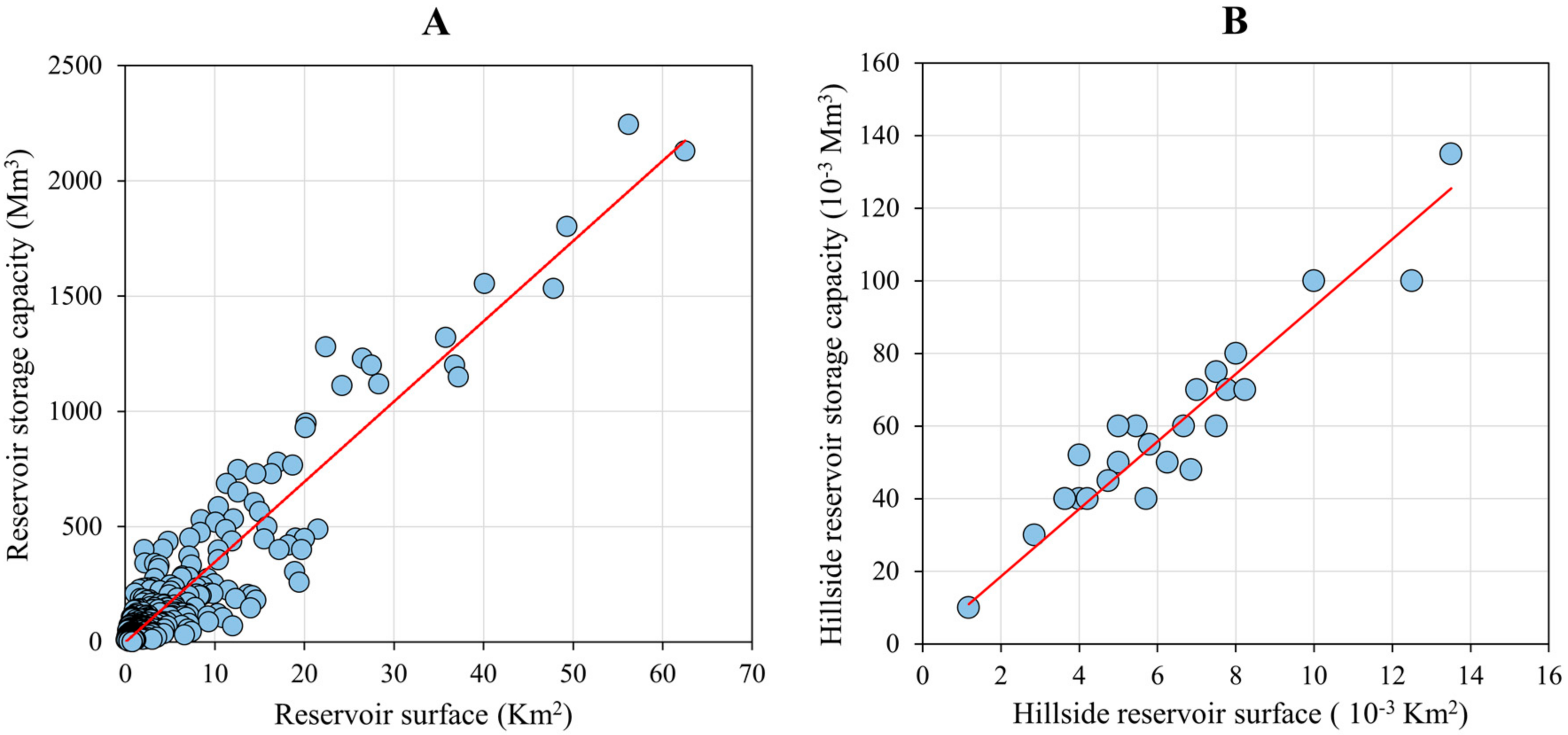
For the manually-digitized reservoirs we had no information on the storage capacity. In order to produce an estimate for this parameter too, we calculated a linear regression between the storage capacity (CAP) and the surface (S) of the reservoir. In fact, two regression models were established, one for the GRanD database reservoirs (Figure 2A)
CAP = 34.79 S
n = 323, r2 = 0.82, p < 0.001
And one for the hillside reservoirs (Figure 2B)
CAP = 9.29 S
n = 25, r2 = 0.89, p < 0.001
Both regressions were forced to pass through the origin (i.e.; no intercept). Equation (1) is based on information for all Mediterranean reservoirs in the GRanD database, and Equation (2) on the compilation of hillside reservoirs in the Tizi-Ouzou region (Algeria) produced by [39], which is the only available study in the area (Table 2).
It should be noted that the database produced by [39] was only used to determine Equation (2). Since the database does not include the geographic coordinates of the reservoirs, it is difficult to differentiate them from other newly digitalized hillside reservoirs. To avoid confusion and duplications, we kept this database only to determine Equation (2).
The storage capacity of the reservoirs can be strongly influenced by their morphology, and notably by the slope of the reservoir surface. The slope of hillside reservoirs is generally very low compared to that of the dams, in particular large dams. Two reservoirs that have the same surface but a different slope can have a very different storage capacity; this is the reason why we kept two different regression models (Figure 2A,B).
Overall, we were able to digitize the surface of 569 additional reservoirs, mostly consisting of small dams and hillside reservoirs. This expanded our database to 670 reservoirs with areas larger than one hectare. On the basis of Equations (1) and (2), we then calculated the storage capacity of these additional reservoirs (i.e., when the newly digitized reservoirs were identified as hillside reservoirs, we applied Equation (2); elsewhere, we used Equation (1). All the reservoirs were then classified according to their storage capacities into seven classes: C1 (CAP > 200 Mm3), C2 (100 < CAP < 200 Mm3), C3 (50 < CAP < 100 Mm3), C4 (20 < CAP < 50 Mm3), C5 (5 < CAP < 20 Mm3), C6 (1 < CAP <5 Mm3), and C7 (CAP < 1 Mm3). It should be noted that hillside reservoirs never exceeded a storage capacity of 1 Mm3, and almost 90% of them had a storage capacity lower than 0.8 Mm3. For small dams, we considered that the maximum capacity limit was 20 Mm3 (see Section 3.2) and found that only 21% of these dams had a storage capacity lower than 1 Mm3. Although there is some overlap with the maximum size of hillside reservoirs, we considered this value to be a reasonable lower limit for small dams.
The integration of all these reservoirs in our modeling framework suffered however from the limited spatial resolution of this framework. In many cases several reservoirs fell within one single 5 arc-minutes grid cell. For the calculation of sediment retention, in addition to the storage capacity we need the amount of water entering and leaving the reservoirs annually. This parameter can only be calculated at the grid point level from our empirical modeling of mean annual water discharge (see Section 2.2). We therefore decided to retain for our modeling of sediment retention only the largest reservoir in a given grid point cell, to which we attributed the corresponding average annual water discharge following the assumption that this reservoir has been constructed along the principal grid point drainage direction. This reduced the total number of reservoirs which could be properly used for modeling to 450.
3. Results and Discussion
3.1. Natural Water and Sediment Fluxes
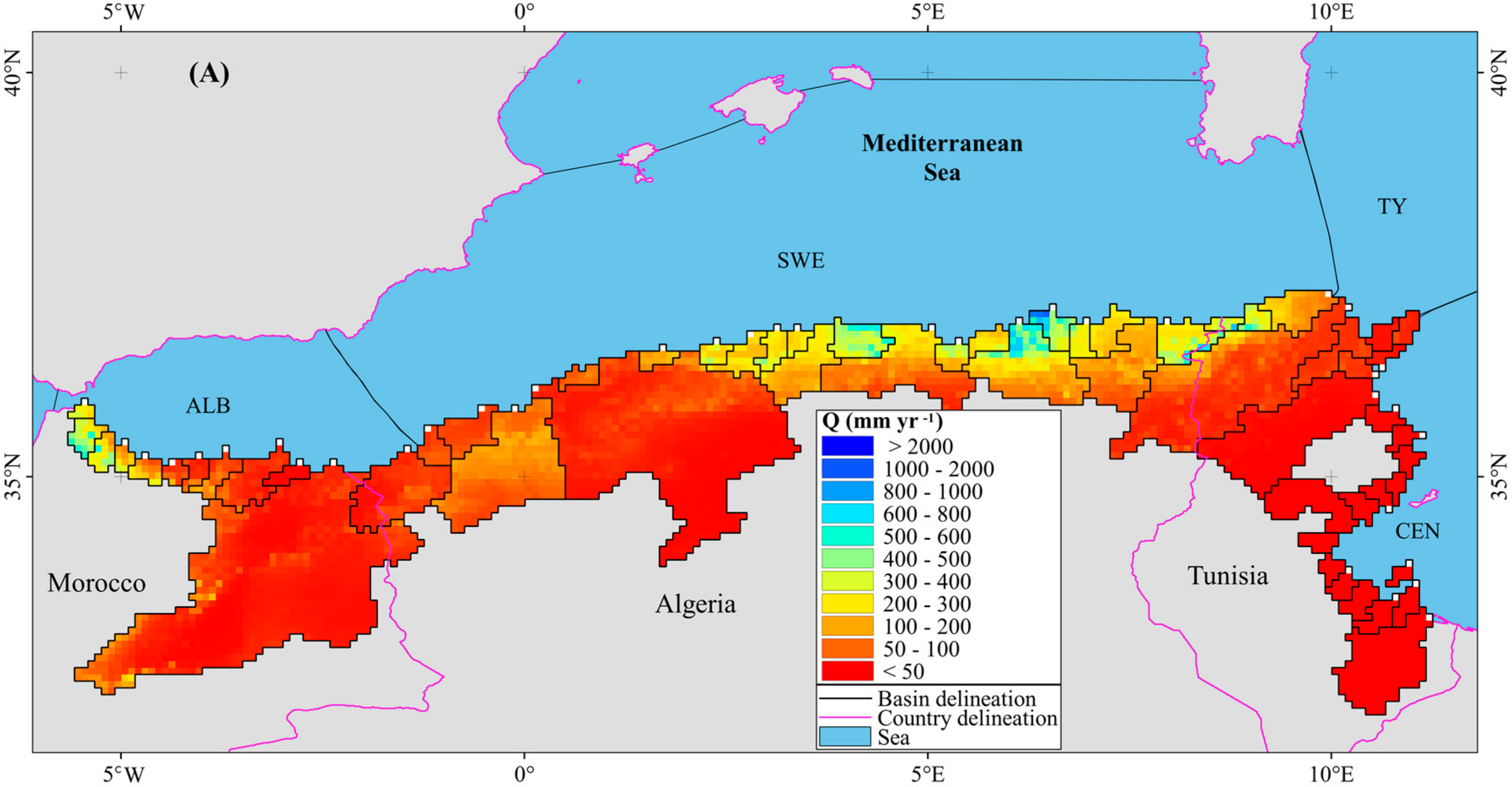
Average water fluxes in the MMB are rather low (Figure 3A). Drainage intensity (water discharge divided by the basin area) for the entire region is only 59 mm per year (Table 3), with little differences between the three countries (52, 62 and 62 mm year−1 for Morocco, Algeria and Tunisia, respectively). More humid conditions are restricted to mountainous areas in the vicinity of the coast and exist in the NW part of Morocco (e.g., the Martil and Laou rivers with Q values of 332 mm year−1 and 252 mm year−1, respectively) and along the central and NE coast of Algeria (e.g., the Sebaou and Bou-Namoussa rivers with Q values of 387 mm year−1 and 290 mm year−1, respectively). The driest conditions are found in the Saharan part of Tunisia and the drainage basins and basin parts which stretch far to the South. All MMB rivers together discharge about 16.2 × 10³ Mm3 year−1 of water to the Mediterranean Sea, which corresponds to less than 4% of the total freshwater flux exported by the Mediterranean drainage basin [7]. About 48% of the MMB water flux stems from the rivers in Algeria. The mean annual water discharge for individual rivers ranges from 1 Mm3 for the Tunisian Saharan rivers to 1720 Mm3 for the Moulouya in Morocco, the largest river in the MMB (55,713 km2). Only about 7% of all rivers have an average water discharge greater than 1000 Mm3 year−1, but they provide more than 32% of the total water flux. On the other hand, 50% of the rivers have a water flux which does not exceed 100 Mm3 year−1 and represent only 7% of the total water flux.
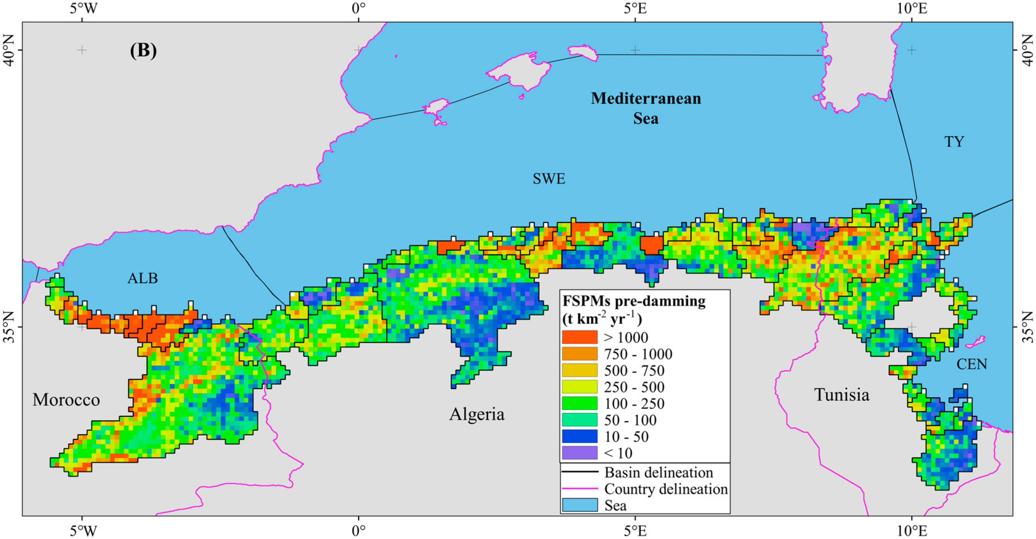
Mountainous regions have also a dominant role for the average sediment fluxes (Figure 3B). High sediment yields (specific suspended particulate matter fluxes, FSPMs) are associated with high Q values, although peak values can also stretch further to the South to lower discharge regions in combination with higher elevations (e.g., in the larger basins such as the Moulouya and Medjerda basins). On average, sediment yields (Table 3) are greatest in Morocco (506 t km−2 year−1), followed by Algeria (328 t km−2 year−1) and by Tunisia (250 t km−2 year−1). Peak values are obtained for the Agrioum River in Algeria (4001 t km−2 year−1) and the Nekor River in Morocco (2956 t km−2 year−1), whereas the lowest values are found for the Bou-Namoussa River in Algeria (15 t km−2 year−1), which is located east of the Seybouse River, and for the Ighzar n-Thyaouth River in Morocco (21 t km−2 year−1), which lies between the Moulouya and Kert rivers. Notice that for the former two rivers, which are probably the most erosive rivers in Africa, our empirical modeling resulted in somewhat lower values than those found in the literature (see Section 2.1). This is due to the fact that we excluded from our regressions a few rivers (notably the Agrioum and Nekor rivers) that had average SPM concentrations greater than 15 g L−1. We considered that such extreme values might indicate possible errors in the literature citations or refer to highly peculiar erosion processes that cannot be reproduced by general regression models (for a more detailed discussion, see [7]).
We estimate that the specific natural suspended particulate matter flux (FSPMs pre-damming) for the entire MMB is 351 t km−2 year−1 and corresponds to an overall sediment delivery to the Mediterranean Sea of 96 Mt year−1. This value is very close to the estimate of 100 Mt year−1 presented by [15] for the same study area. About 60% of this value is exported by only seven rivers (Moulouya, Medjerda, Agrioun, Kert, Nekor, Chelif and Seybousse), and Algerian rivers alone account for about 43% of it. Compared to the world average FSPMs of 150 t km−2 year−1 [40], it becomes evident that the Mediterranean Maghreb basin average erosion rates are higher than those in other regions of the world. This is also apparent when compared to other key environments in the Mediterranean Sea. Taking the Gulf of Lions (GoL) drainage basin as an example (which includes the Rhone River, nowadays the largest Mediterranean river in terms of its average water discharge and also characterized by remarkable sediment yields—[34]), we calculate that, despite the fact that the GoL rivers discharge into the Mediterranean a water flux that is four times greater than the water flux of the MMB rivers, their SPM flux represents only 40% of the SPM flux from the MMB rivers.
3.2. Sediment Retention by Dams
The values cited above represent average long-term means that do not take into account sediment retention by recent damming of the MMB rivers. In order to quantify the latter at the scale of our study region, we combined our inventory of dams (Figure 4A and Table 3) with our modeling of water and SPM fluxes according to the method described by [7]. Dams of various sizes stretch over the entire study region (Figure 4A), except in the Saharan part of Tunisia, where conditions are too dry for the sustainable exploitation of surface water resources. Consequently, about 76% of the MMB area is drained into dams (87% for Algeria, 86% for Morocco and 51% for Tunisia). The average density of all types of dams is about 2.5 dams per 103 km2, with increasing densities as the size of the dams decreases (0.4, 0.8 and 1.3 dams per 103 km2 for large dams, small dams and hillside reservoirs, respectively). When relating the densities to the areas which are drained into the dams (hence omitting to some extent the Saharan part of Tunisia), it is clear that the average dam densities increase from Morocco to Tunisia (1.0 dams per 103 km2 for Morocco, 3.4 for Algeria and 5.9 for Tunisia), which is opposite to the average sediment yields in these countries (see Section 3.1). Construction of dams is obviously constrained by the availability of existing water resources and the natural erodibilities of the corresponding land surfaces. Notice also from Table 3 that while all large and small dams in our inventory could be included in the modeling approach, we could only include 37% of the hillside reservoirs (46%, 31% and 24% for Algeria, Morocco and Tunisia, respectively) due to the model limited resolution (see Section 2.3). Sediment retention by hillside reservoirs may therefore be somewhat underestimated in our study.
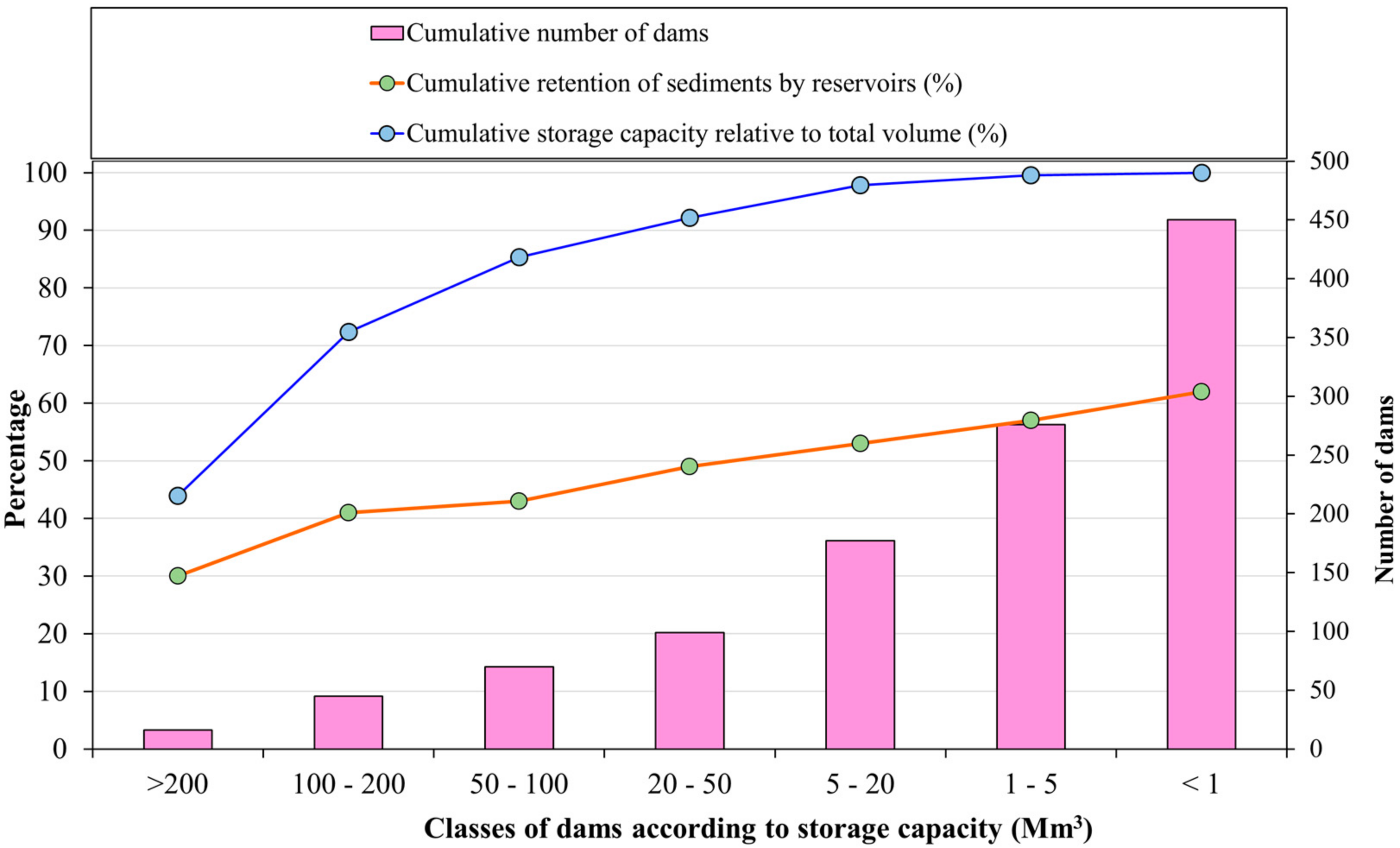
Including dams in the routing of suspended sediments to the sea reduces the average SPM flux from the MMB to the sea to 36 Mt year−1, which corresponds to a post-damming FSPMs value of 133 t km−2 year−1. In other words, 62% of the natural SPM flux (Section 3.1) is retained behind dams. Retention rates are highest in the Tunisian basin part (72%), followed by the Algerian (63%) and the Moroccan basin parts (55%). This is in agreement with the density of dams, which is highest in Tunisia and decreases westward toward Morocco. In terms of the absolute SPM fluxes, the greatest retention is observed for Algeria (26 Mt year−1), followed by Morocco (19 Mt year−1) and Tunisia (14 Mt year−1). Interestingly, when only considering the dams included in the GRanD database (as was the case in the study by [7]), sediment retention behind the dams accounts for only 36% of the natural SPM flux to the Mediterranean Sea. The present results therefore demonstrate that small reservoirs are quantitatively crucial for the interception of sediments in river basins compared to large reservoirs. The majority of the MMB reservoirs (~85%) in the GRanD database have a storage capacity greater than or equal to 20 Mm3. If we consider this value as an appropriate threshold between small and large reservoirs, we can make the following observations: small reservoirs have very limited capacities (cumulative capacity of 1.1 versus 12.8 km3 for large dams), intercept annually less water discharge (cumulative interception of 8.4 versus 20.1 km3 year−1 for large dams), drain smaller areas (mean area of 151 versus 1525 km2 for large dams), and have shorter water residence time in the reservoir (mean of 0.13 versus 0.63 years for large dams). They nevertheless assign a significant anthropogenic signature to the global sediment flux in the MMB (Figure 5) and enhance mean retention by 13% (from 49 to 62%) as compared to large reservoirs. It can also be seen from Figure 5 that the different size classes we created increase about linearly the average sediment retention in the MMB from large to small basins (except for very large reservoirs which are underrepresented in the MMB), whereas the total number of these reservoirs increase more or less exponentially.
3.3. Economic and Environmental Implications
Our combination of a spatially explicit mapping of natural sediment yields with an inventory of reservoirs in the MMB also allows evaluating the loss of storage capacity and the life spans of the reservoirs. On the one hand, this can be compared with observed accumulation rates behind dams for validation purposes. On the other hand, it may also help to assess the loss of performance and economic value of existing dams and to evaluate the feasibility of future damming projects.
For this purpose, we followed the approach of [7] and converted the calculated mass accumulation of sediments into volumetric values by assuming an average density of 0.96 t m−3, as proposed by [41]. The reservoirs of the MMB consequently retain a volume of 54 Mm3 of sediment each year, which corresponds to an annual loss of storage capacity of about 0.39%. This volume can be further split into 22 Mm3 for the Algerian part (annual loss of 0.27%), 14 Mm3 for the Tunisian part (annual loss of 0.39%) and 18 Mm3 for the Moroccan part (annual loss of 0.89%). These values match well with other estimates from the literature. Remini estimated the sediment retention in reservoirs behind Algerian dams to be 20 Mm3 [42], which accounts for a reduction of their capacity (6.2 Mm3 according to [43]) of 0.3% each year. This value is identical to our estimate. Mammou and Louati proposed a capacity loss for Tunisian dams between 0.5 and 1% each year [28], compared to the 0.4% we found. Due to its greater relief and higher natural sediment yields, the values proposed for the Moroccan part of the MMB generally exceed 0.7% [20,22]. We estimate an annual capacity loss of about 0.9%. At larger scales, Remini, W. and Remini, B. evaluated the annual capacity loss of the 230 dams in North Africa to be 0.54% per year [25], which is only slightly higher than our results for the MMB. But many of the reservoirs in their study are located outside our study region, especially for Morocco. Notice that only the three Moroccan dams Eddahabi, El Massira and Ben El Ouidane in the Atlantic drainage basin of the Maghreb retain annually 18.3 Mm3 of sediment, which is equivalent to one third of the overall sediment retention in the entire MMB.
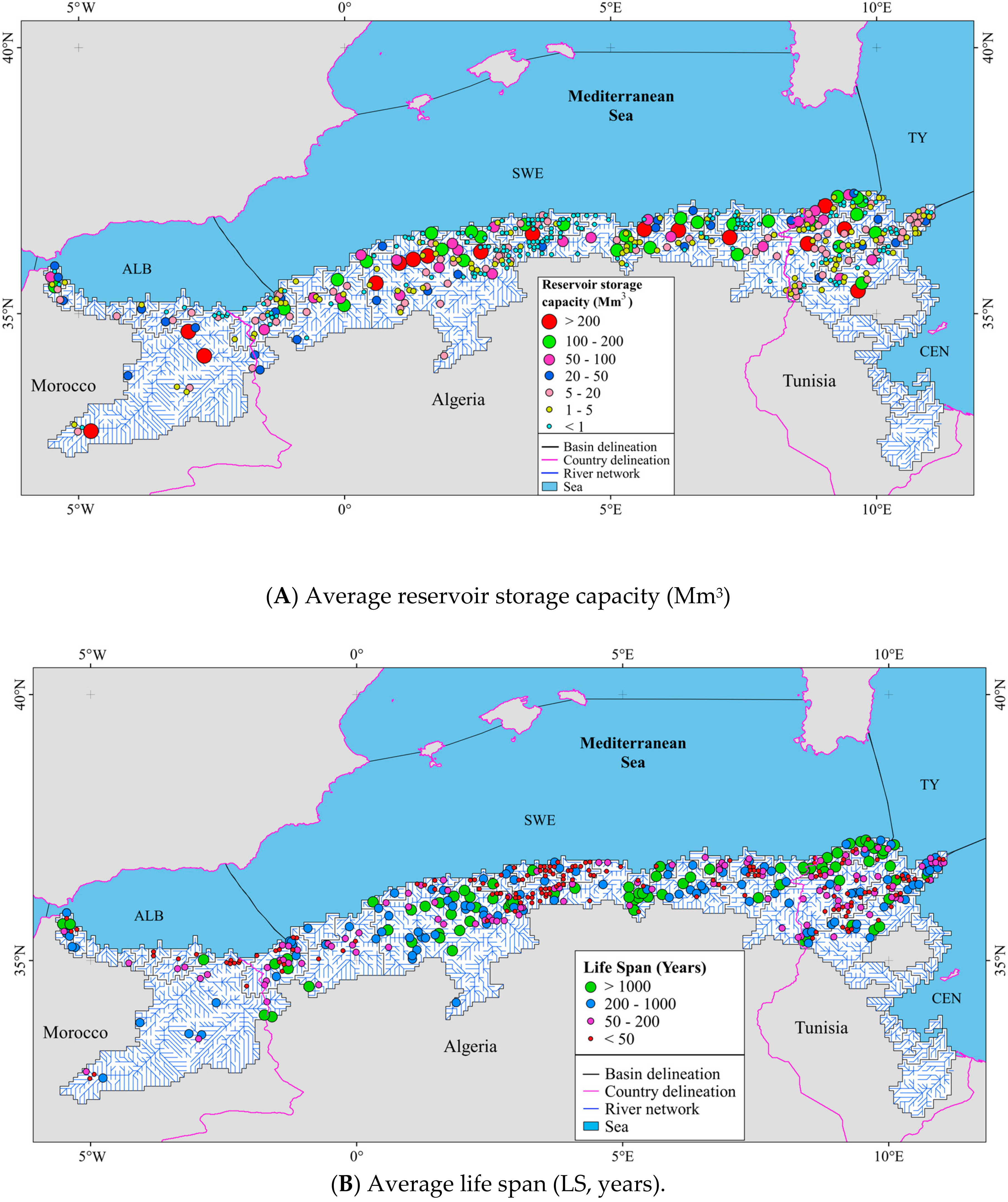
The life span of reservoirs (LS, year) can consequently be estimated via the ratio between the reservoir capacity and the annual volume of sediments that is retained behind the reservoir dams. Figure 4B shows the average LS for the 450 reservoirs considered in our modeling approach. It varies from less than 10 years to 143 × 103 years, with a median of 150 years and lower and upper quartiles of 50 and 550 years. About 35% of these reservoirs have a LS of less than 50 years in relation to reduced storage capacities (90% have a storage capacity of less than 2.5 Mm3). The majority is in the Algerian basin part (62%), followed by the Tunisian (28%) and the Moroccan basin parts (10%). On the other side, 25% of all reservoirs have LS between 50 and 200 years, and 23% between 200 and 1000 years. Only for 17% of the reservoirs LS exceeds 1000 years.
For the 101 dams in our database which were collected from the GRanD database and the national agencies of the Maghreb countries (see Section 2.3), the precise construction dates were known (Table 1) and therefore we could predict their filling. In 2016, the total sediment volume accumulated in these dams was 1.5 km3, equivalent to a fill of 12% of the total storage capacity (11.7 km3). The average silting is thus 37 Mm3 year−1, and if nothing changes, about 30% of their initial capacity would be lost by 2060. Interestingly, with our modeling tools we can also calculate that, if these were the only dams in the MMB and no smaller and hillside dams existed to catch part of the sediment fluxes further upstream, the average silting would increase to 42 Mm3 year−1 and the 30% capacity loss would arrive by the year 2050. These results confirm the findings of [24], who suggested that the delay of siltation of large dams is possible by installing smaller structures further upstream.
Table 4 lists the siltation rates for the 11 dams in the MMB that are the most affected by rapid filling. Two examples are worth being cited more in detail. One is the Mohamed Ben Abd Lekrim El Khattabi dam in the Nekor basin of Morocco, with a storage capacity of 43 Mm3. Our study shows that average annual silting is here 3.1 Mm3, which corresponds to a storage capacity loss of 7.2%. These figures are well confirmed by the study of [26], who estimated an average silting rate of 2.7 Mm3 year−1 and an annual storage capacity loss of 6.3%. The accelerated siltation of this dam is closely linked to the extremely high erosion rates in the Nekor basin, one of the highest in the world (see Section 2.1). Without measures to prevent siltation, this dam would have been completely filled only 15 years after its construction in 1981.
The second example is the Ighil Emda dam in Algeria, located in a drainage basin with the same name. We calculated here an average sediment filling of 1.1 Mm3 year−1 and an average capacity loss of 0.67% year−1. Since its commissioning in 1953, the Ighil Emda dam has accumulated nearly 66 Mm3 of sediments and lost 42% of its capacity. These results are very close to those presented in the study by [44], who estimated the cumulative silting during the period 1953–1993 from bathymetric surveys to be 52 Mm3. During this 40-year period, the dam has lost nearly 35% of its initial capacity. This corresponds to an average capacity loss of 0.87% year−1. The main reason for this rapid silting is the nature of its drainage basin, formed by soft rocks, in combination with a thin plant cover and a predominance of the agricultural domain [44].
It is finally also interesting to look at the theoretical sediment starvation in the coastal areas, which can be estimated from the difference between the pre-damming river fluxes of SPM and the present-day SPM fluxes normalized to the coastline length. The latter is about 422 km, 1210 km, and 1225 km for Morocco, Algeria and Tunisia, respectively. Although this information does not take into account the integration of sediment starvation over time (which depends on the precise construction date of dams), neither the existence of littoral drifts which redistribute the sediments into the coastal domain, it is nevertheless indicative for the potential risk of coastal erosion in relation to decreasing river sediment supply. Maximum values of 45 × 103 t km−1 year−1 are obtained for the coast of Morocco, which should consequently be the most threatened by beach erosion and sea level rise. Note that this value per kilometer of coastline corresponds to about the average SPM flux produced annually within the whole basin of a typical coastal river in the Gulf of Lions—like the Tet River, with a basin area of 1400 km2 [34,45]. In other words, the sediments produced elsewhere in a hinterland area of 1400 km2 are equivalent to the amount of sediments missing every km along the Moroccan coast. The corresponding values for Algeria and Tunisia are also rather high: 21 × 103 t km−1 year−1 and 12 × 103 t km−1 year−1, respectively.
4. Conclusions
For the first time a spatially explicit assessment of the impact of river damming on the natural sediment fluxes to the sea could be produced for the Mediterranean Maghreb basin (MMB), a region which is characterized by a critical state of the available surface water resources and by strong mechanical erosion rates. Our data are based on modeling, which often represents simplifications with respect to reality and which is always constraint by the validity of the basic assumptions leading to the model formulations. Modeling on a grid point scale is limited by the quality of the input data and the adequacy of the regression models used to predict the riverine sediment fluxes. It is furthermore difficult to assess the quality of the literature estimates we used to adjust our regressions and which define the natural (pre-damming) state of the river systems, because anthropogenic perturbations can have a long history in the Mediterranean area. Nevertheless, the values we produced fit very well with other literature estimates, both in terms of the general sediment budgets and with regard to the measured reservoir silting rates, which makes us confident on their reliability.
Our results clearly demonstrate that, because of damming, nowadays only slightly more than one third of the natural river sediment fluxes reach the coastal Mediterranean waters of the Maghreb. Contrary to other hot spot areas of river damming, such as the East, Southern and Southeast Asian region where most of the sediment retention is related to the existence of mega dams [46], a considerable part of the sediment retention is here related to the existence of small dams and hillside reservoirs. Consequently, when only considering the large dams as those documented in the GRanD database, sediment retention is strongly underestimated. Using the latter database alone results in an overall sediment retention of about 36%, while the supplementary dams and hillside reservoirs we collected increase this value to 62%.
Large and small reservoirs in regulated basins trap 30% and 23% of the global riverine sediment fluxes according to [9]. Our retention estimates are therefore substantially higher than those given at the global scale, but the differences are not as striking as one may expect. In the [9] estimate, large reservoirs correspond to CAP > 500 Mm3, which are rare in the MMB, and the 62% retention we calculated should rather be compared to the 23% retention that [9] found for small dams. The major difference is that small dams have shorter life spans than large dams, and the economic exploitation of these structures is limited in time. Notice that according to our assessment, 35% of the MMB reservoirs have life spans of less than 50 years in relation to reduced storage capacities, which requires frequent renewal and replacement of these structures for further development. It should be also mentioned that sediment retention rates alone are not necessarily an appropriate measure of the potential impact of damming on natural systems. Our data reveal some negative correlation between sediment retention and natural erosion rates in the three Maghreb countries (see Section 3.2), which could be explained by the greater difficulties to build dams in terrains with steep slopes and high natural sediment yields. Although sediment retention rates are “only” 55% in the Moroccan part of MMB, it is probably here where riverine sediment starvation may have the greatest impacts on the coastline dynamics.
Author Contributions
M.S. conducted the data analysis and wrote the draft of the manuscript. M.S. and W.L. worked on subsequent drafts of the manuscript. M.S., W.L., F.B., Y.L. and E.R. contributed to the final version of the manuscript.
Funding
This work was supported by the National Centre of Scientific Research—France (Centre National de la Recherche Scientifique—France, CNRS) through the attribution of a PhD grant to M.S., and by the DEMEAUX project funded by the regional council Occitania and the FEDER.
Acknowledgments
We are grateful to three anonymous reviewers for their valuable and useful comments during the review process.
Conflicts of Interest
The authors have no conflict of interest to declare.
References and Note
- García-Ruiz, J.M.; Ignacio López-Moreno, J.I.; Vicente-Serrano, S.M.; Lasanta-Martínez, T.; Beguería, S. Mediterranean water resources in a global change scenario. Earth Sci. Rev. 2011, 105, 121–139. [Google Scholar] [Green Version]
- Van Cappellen, P.; Maavara, T. Rivers in the Anthropocene: Global scale modifications of riverine nutrient fluxes by damming. Ecohydrol. Hydrobiol. 2016, 16, 106–111. [Google Scholar] [CrossRef]
- Walling, D.E.; Fang, D. Recent trends in the suspended sediment loads of the World’s rivers. Glob. Planet. Chang. 2003, 39, 111–126. [Google Scholar] [CrossRef]
- Brunel, C.; Certain, R.; Sabatier, F.; Robin, N.; Barusseau, J.P.; Alemant, N.; Raynal, O. 20th century sediment budget trends on the Western Gulf of Lions shoreface (France): An application of an integrated method for the study of sediment coastal reservoirs. Geomorphology 2014, 204, 625–637. [Google Scholar] [CrossRef]
- Besset, M.; Anthony, E.J.; Sabatier, F. River delta shoreline reworking and erosion in the Mediterranean and Black Seas: the potential roles of fluvial sediment starvation and other factors. Elem. Sci. Anth. 2017, 5, 54. [Google Scholar] [CrossRef] [Green Version]
- Vanmaercke, M.; Poesen, J.; Verstraeten, G.; de Vente, J.; Ocakoglu, F. Sediment yield in Europe: Spatial patterns and scale dependency. Geomorphology 2011, 130, 142–161. [Google Scholar] [CrossRef]
- Sadaoui, M.; Ludwig, W.; Bourrin, F.; Romero, E. The impact of reservoir construction on riverine sediment and carbon fluxes to the Mediterranean Sea. Prog. Oceanogr. 2018, 163, 94–111. [Google Scholar] [CrossRef]
- Lehner, B.; Reidy Liermann, C.; Revenga, C.; Vorosmarty, C.; Fekete, B.; Crouzet, P.; Doll, P.; Endejan, M.; Frenken, K.; et al. Global Reservoir and Dam Database, Version 1 (GRanDv1): Dams, Revision 01; NASA Socioeconomic Data and Applications Center (SEDAC): Palisades, NY, USA, 2011. [Google Scholar] [CrossRef]
- Vörösmarty, C.J.; Meybeck, M.; Fekete, B.; Sharma, K.; Green, P.; Syvitski, J.P.M. Anthropogenic sediment retention: major global impact from registered river impoundments. Glob. Planet. Chang. 2003, 39, 169–190. [Google Scholar] [CrossRef]
- Syvitski, J.P.M.; Vörösmarty, C.; Kettner, A.J.; Green, P. Impact of humans on the flux of terrestrial sediment to the global coastal ocean. Science 2005, 308, 376–380. [Google Scholar] [CrossRef] [PubMed]
- Ludwig, W.; Meybeck, M.; Abousamra, F. Riverine Transport of Water, Sediments, and Pollutants to the Mediterranean Sea; UNEP/MAP: Athens, Greece, 2003; Available online: http://web.unep.org/unepmap/mts-141-riverine-transport-water-sediments-and-pollutants-mediterranean-sea (accessed on 12 July 2018).
- Fournier, F. Climat et Erosion; Presses Universitaires de France: Paris, France, 1960; p. 201. (In French) [Google Scholar]
- Dedkhov, A.P.; Mozzherin, D.I. Erosiya I stok nanosov na zemle, Izdatelstvo Kasagskogo Universsiteta. 1984. [Google Scholar]
- Walling, D.E.; Webb, B.W. Material Transport by the World’s Rivers: Evolving Perspectives. Available online: http://hydrologie.org/redbooks/a164/iahs_164_0313.pdf (accessed on 1 May 2016).
- Probst, J.L.; Suchet, P.A. Fluvial suspended sediment transport and mechanical erosion in the Maghreb (North Africa). Hydrol. Sci. J. 1992, 37, 621–636. [Google Scholar] [CrossRef]
- Hijmans, R.J.; Cameron, S.E.; Parra, J.L.; Jones, P.G.; Jarvis, A. Very high resolution interpolated climate surfaces for global land areas. Int. J. Climatol. 2005, 25, 1965–1978. [Google Scholar] [CrossRef] [Green Version]
- Ghenim, A.; Seddini, A.; Terfous, A. Variation temporelle de la dégradation spécifique du bassin versant de l’Oued Mouilah (nord-ouest algérien). Hydrol. Sci. J. 2008, 53, 448–456. (In French) [Google Scholar] [CrossRef]
- Tourki, M.; Khanchoul, K.; Le Bissonnais, Y.; Belala, F. Sediment yield assessment in the Upper Wadi Kebir catchment, Kébir Rhumel River, Northeast of Algeria (1973–2006). Rev. Sci. Technol. 2017, 34, 122–133. [Google Scholar]
- Inoubli, N.; Raclot, D.; Mekki, I.; Moussa, R.; Le Bissonnais, Y. A spatiotemporal multiscale analysis of runoff and erosion in a Mediterranean marly catchment. Vadose Zone J. 2017, 16. [Google Scholar] [CrossRef]
- Badraoui, A.; Hajji, A. Envasement des retenues de barrages. La Houille Blanche 2001, 6–7, 72–75. [Google Scholar] [CrossRef]
- Demmak, A. Contribution à l’Étude de l’Érosion et du Transport Solide en Algérie Septentrionale. Thèse de Docteur-Ingénieur, Université Paris-VI, Paris, France, 1982. (In French). [Google Scholar]
- Lahlou, A. Etude actualisée de l’envasement des barrages au Maroc. Rev. Sci. Eau. 1988, 6, 337–356. (In French) [Google Scholar]
- Estienne, P.; Godard, A. Climatologie; Librairie Armand Colin: Paris, France, 1970. (In French) [Google Scholar]
- Remini, B.; Leduc, C.; Hallouche, W. Évolution des grands barrages en régions arides: Quelques exemples algériens. Sécheresse 2009, 20, 96–103. (In French) [Google Scholar]
- Remini, W.; Remini, B. La sédimentation dans les barrages de l’Afrique du Nord. Larhyss 2003, 2, 45–54. (In French) [Google Scholar]
- Lahlou, A. Envasement du barrage Mohamed Ben Abdelkrim Al Khattabi et lutte anti-érosive du bassin versant montagneux situe à l’amont. IAHS Publ. 1990, 194, 243–252. (In French) [Google Scholar]
- Kassoul, M.; Abdelkader, A.; Belorgey, M. Caractérisation de la sédimentation des barrages en Algérie. Revue des Sciences de l’Eau 1997, 10, 339–358. (In French) [Google Scholar] [CrossRef] [Green Version]
- Mammou, B.A.; Louati, M.H. Evolution temporelle de l’envasement des retenues de barrages de Tunisie. Rev. Sci. Eau 2007, 20, 201–210. (In French) [Google Scholar] [CrossRef] [Green Version]
- Seklaoui-Oukid, O. Valorisation des Sédiments du Barrage d’El Merdja Sidi Abed: Etude Technoéconomique. Available online: http://www.secheresse.info/spip.php?article60431 (accessed on 1 April 2016). (In French).
- Lehner, B.; Verdin, K.; Jarvis, A. New global hydrography derived from spaceborne elevation data. Eos Trans. AGU 2008, 89, 93–94. [Google Scholar] [CrossRef]
- Harris, I.; Jones, P.D.; Osborn, T.J.; Lister, D.H. Updated high resolution grids of monthly climatic observations—The CRU TS3.10 Dataset. Int. J. Climatol. 2014, 34, 623–642. [Google Scholar] [CrossRef] [Green Version]
- Dürr, H.; Meybeck, M.; Dürr, S.H. Lithologie composition of the earth’s continental surfaces derived from a new digital map emphasing riverine material transfer. Glob. Biochem. Cycles 2005, 19. [Google Scholar] [CrossRef]
- Mayaux, P.; Bartholomé, E.; Cabral, A.; Cherlet, M.; Defourny, P.; Di Gregorio, A.; Diallo, O.; Massart, M.; Nonguierma, A.; Pekel, J.F.; et al. A new land-cover map of Africa for the year 2000. J. Biogeogr. 2004, 31, 861–877. [Google Scholar] [CrossRef]
- Sadaoui, M.; Ludwig, W.; Bourrin, F.; Raimbault, P. Controls, budgets and variability of riverine sediment fluxes to the Gulf of Lions (NW Mediterranean Sea). J. Hydrol. 2016, 540, 1002–1005. [Google Scholar] [CrossRef]
- Vörösmarty, C.J.; Sharma, K.; Fekete, B.; Copeland, A.H.; Holden, J.; Marble, J.; Lough, J.A. The storage and aging of continental runoff in large reservoir systems of the world. Ambio 1997, 26, 210–219. [Google Scholar]
- ANBT. National Agency for Dams and Transfers. 2016. Available online: http://www.soudoud-dzair.com (accessed on 1 June 2016).
- ABHL. Loukkos Hydraulic Basin Agency/Tétouan. 2016. Available online: http://www.abhloukkos.ma/abhl/index.php/fr/ (accessed on 1 June 2016).
- DGBGTH. General Directorate for Dams and Major Hydraulic Works. 2016. http://www.semide.tn/ (accessed on 1 June 2016).
- Saradouni, F. Contribution à l’Etude de la Vulnérabilité des Retenues Collinaires vis-à-vis des Aléas Naturels, dans un Système d’Information Géographique (SIG). Available online: https://dl.ummto.dz/handle/ummto/910 (accessed on 11 July 2018). (In French).
- Ludwig, W.; Probst, J.L. River sediment discharge to the oceans: Present-day controls and global budgets. Am. J. Sci. 1998, 296, 265–295. [Google Scholar] [CrossRef]
- Minear, J.T.; Kondolf, G.M. Estimating reservoir sedimentation rates at large spatial and temporal scales: A case study of California. Water Resour. Res. 2009, 45. [Google Scholar] [CrossRef] [Green Version]
- Remini, B. L’envasement des Barrages: Quelques Exemples Algériens. Revue Techniques Sciences Méthodes. 1999. Available online: http://www.beep.ird.fr/collect/bre/index/assoc/HASH6487.dir/20-165-171.pdf (accessed on 1 April 2016).
- Riad, S.; Salih, A. Options for future water security in the Arab Countries. In Proceeding of the First International Conférence on the Geology of Africa, Assiut, Egypt, 23–25 November 1999; pp. 459–466. [Google Scholar]
- Remini, B.; Kettab, A.; Hmat, H. Envasement du Barrage d’IGHIL EMDA (Algérie). 1995. Available online: https://www.shf-lhb.org/articles/lhb/pdf/1995/02/lhb1995008.pdf (accessed on 1 March 2016).
- Serrat, P.; Ludwig, W.; Navarro, B.; Blazi, J.L. Variabilité spatio-temporelle des flux de matières en suspension d’un fleuve côtier méditerranéen: la têt (France). Earth Planet. Sci. Lett. 2001, 333, 389–397. [Google Scholar] [CrossRef]
- Gupta, H.; Kao, S.-J.; Dai, M. The rôle of mega-dams in reducing sediment fluxes: A case study of large Asian Rivers. J. Hydrol. 2012, 464–465, 447–458. [Google Scholar] [CrossRef]
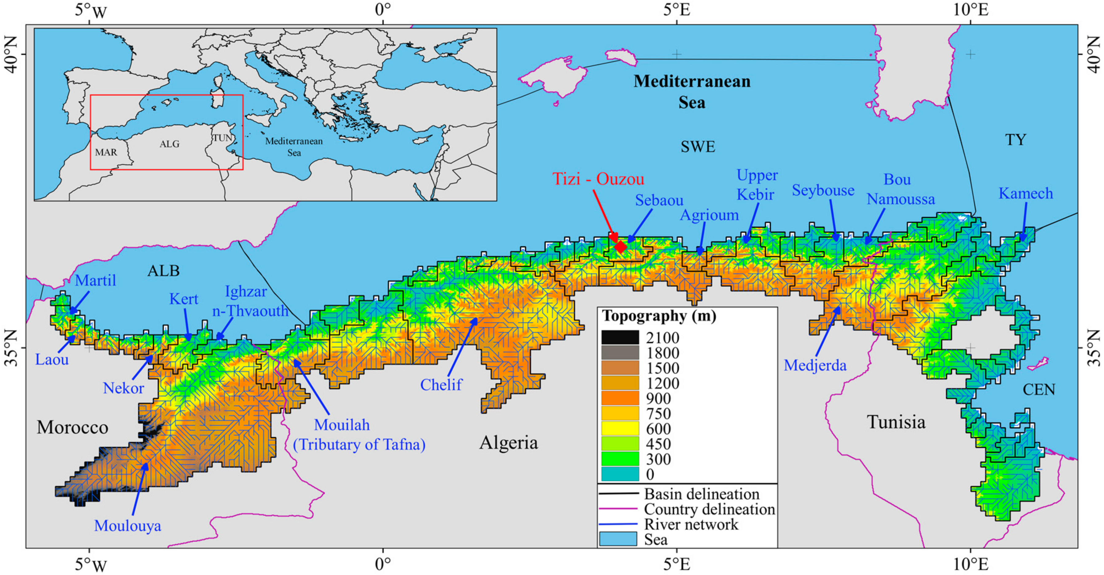
Figure 1.
Location map of the Mediterranean Maghreb Basin (MMB) and delimitation of its drainage basins at a spatial resolution of 5 arc-minutes. Topography was extracted from the digital elevation model of [16]. All rivers and locations which are mentioned in the text have been included in this figure. Abbreviations: ALB: Alboran sub-basin, CEN: Central sub-basin, SWE: Southwestern sub-basin, TY: Tyearrhenian sub-basin.

Figure 2.
Linear relationships between storage capacity and reservoir surface (A) using the Mediterranean reservoirs of the GRanD database [8] and (B) using the hillside reservoir database of [39].

Figure 3.
Spatial distribution of (A) specific riverine water discharge (Q-mod) and (B) specific suspended particulate matter fluxes (FSPMs pre-damming) in the Mediterranean Maghreb Basin according to the study of [7].
Figure 3.
Spatial distribution of (A) specific riverine water discharge (Q-mod) and (B) specific suspended particulate matter fluxes (FSPMs pre-damming) in the Mediterranean Maghreb Basin according to the study of [7].


Figure 4.
Geographical distribution of the 450 dams and hillsides implemented in the modeling part of this study.
Figure 4.
Geographical distribution of the 450 dams and hillsides implemented in the modeling part of this study.

Figure 5.
Cumulative reservoir storage capacity (blue line) and sediment retention (orange line) according to various classes of reservoir storage capacities. The cumulative number of dams in each class is shown as well (purple bars). For further explanations, see text.
Figure 5.
Cumulative reservoir storage capacity (blue line) and sediment retention (orange line) according to various classes of reservoir storage capacities. The cumulative number of dams in each class is shown as well (purple bars). For further explanations, see text.


Table 1.
Characteristics of the 101 dams of the Mediterranean Maghreb Basin (MMB) considered in this study.
Table 1.
Characteristics of the 101 dams of the Mediterranean Maghreb Basin (MMB) considered in this study.
| NB | Dams | Country | Year of Construction | CAP (Mm3) | S (km2) | H (m) | Source |
|---|---|---|---|---|---|---|---|
| 1 | Ain Dalia | Algeria | 1987 | 82 | 3.4 | 24 | GRanD |
| 2 | Ain zada | Algeria | 1986 | 125 | 6.9 | 18 | GRanD |
| 3 | Ajras | Morocco | 1969 | 3 | 0.4 | 8 | GRanD |
| 4 | Al Thelat-Laou | Morocco | 1934 | 30 | 0.9 | 33 | GRanD |
| 5 | Asmir | Morocco | 1991 | 43 | 2.6 | 17 | ABHL |
| 6 | Bakhada | Algeria | 1935 | 56 | 3.5 | 16 | GRanD |
| 7 | Barbara-Zoutina | Tunisia | 1999 | 58 | 3.9 | 15 | GRanD |
| 8 | Beni Amrane | Algeria | 1988 | 12 | 1.0 | 12 | ANBT |
| 9 | Beni Bahdel | Algeria | 1946 | 63 | 1.2 | 53 | GRanD |
| 10 | Beni Boussaid | Algeria | 2007 | 1 | 0.2 | 7 | ANBT |
| 11 | Beni Haroune | Algeria | 2003 | 998 | 44.4 | 22 | ANBT |
| 12 | Beni metir | Tunisia | 1954 | 73 | 1.8 | 41 | GRanD |
| 13 | Beni zid | Algeria | 2000 | 40 | 3.5 | 12 | ANBT |
| 14 | Bezrik | Tunisia | 1959 | 7 | 0.7 | 9 | GRanD |
| 15 | Bir M'Cherga | Tunisia | 1971 | 160 | 4.3 | 37 | GRanD |
| 16 | Bou Hanifa | Algeria | 1948 | 73 | 2.7 | 27 | GRanD |
| 17 | bou heurtna | Tunisia | 1976 | 118 | 7.1 | 17 | GRanD |
| 18 | Bou Roumi | Algeria | 1985 | 188 | 1.7 | 111 | GRanD |
| 19 | Boughzoul | Algeria | 1934 | 55 | 16.3 | 3 | GRanD |
| 20 | Bougous | Algeria | 2010 | 65 | 2.8 | 24 | ANBT |
| 21 | Boukourdene | Algeria | 1992 | 110 | 3.1 | 36 | ANBT |
| 22 | Boussiaba | Algeria | 2000 | 120 | 10.3 | 12 | ANBT |
| 23 | Cap Djinet | Algeria | 1990 | 13 | 0.4 | 34 | ANBT |
| 24 | Cheffia | Algeria | 1965 | 171 | 7.0 | 24 | GRanD |
| 25 | Chelif | Algeria | 2009 | 130 | 7.2 | 18 | ANBT |
| 26 | Cheufra | Algeria | 1935 | 14 | 1.3 | 11 | GRanD |
| 27 | Chiba | Tunisia | 1963 | 8 | 1.1 | 7 | GRanD |
| 28 | Colonel bougara | Algeria | 1988 | 13 | 2.3 | 6 | GRanD |
| 29 | Dahmouni | Algeria | 1987 | 41 | 3.4 | 12 | GRanD |
| 30 | Deurdeur | Algeria | 1984 | 115 | 4.8 | 24 | ANBT |
| 31 | Djoumine | Tunisia | 1983 | 130 | 5.4 | 24 | GRanD |
| 32 | Douera | Algeria | 2014 | 87 | 1.3 | 65 | ANBT |
| 33 | Draa Diss | Algeria | 2016 | 151 | 0.5 | 80 | ANBT |
| 34 | El Abid | Tunisia | 2002 | 10 | 1.4 | 7 | DGBGTH |
| 35 | El Agrem | Algeria | 2002 | 34 | 2.3 | 15 | ANBT |
| 36 | El Djomoaa | Morocco | 1992 | 7 | 0.5 | 12 | ABHL |
| 37 | El habib-ouareb | Tunisia | 1988 | 110 | 5.0 | 22 | GRanD |
| 38 | El Hamiz | Algeria | 1990 | 16 | 0.9 | 17 | ANBT |
| 39 | El hamma | Tunisia | 2002 | 12 | 0.6 | 21 | DGBGTH |
| 40 | El Masri | Tunisia | 1968 | 6 | 0.7 | 8 | ANBT |
| 41 | Ennakhela | Morocco | 1961 | 13 | 0.6 | 22 | GRanD |
| 42 | Erraguen | Algeria | 1961 | 200 | 11.0 | 18 | ANBT |
| 43 | Fergoug | Algeria | 1970 | 18 | 0.7 | 26 | GRanD |
| 44 | Gargar | Algeria | 1988 | 450 | 19.0 | 24 | GRanD |
| 45 | GHrib | Algeria | 1938 | 280 | 7.1 | 39 | GRanD |
| 46 | GuenitraOumToub | Algeria | 1984 | 125 | 1.3 | 96 | GRanD |
| 47 | H.M.Bouhemdene | Algeria | 1987 | 220 | 5.1 | 43 | GRanD |
| 48 | Hammam Grouz | Algeria | 1987 | 45 | 2.3 | 20 | GRanD |
| 49 | Harreza | Algeria | 1984 | 70 | 1.0 | 70 | GRanD |
| 50 | Hassan II | Morocco | 2000 | 400 | 11.0 | 36 | ABHL |
| 51 | Hassan II Midelt | Morocco | 2006 | 400 | 11.8 | 34 | ABHL |
| 52 | Ighil Emda | Algeria | 1953 | 156 | 2.9 | 53 | ANBT |
| 53 | kasseb | Tunisia | 1969 | 81 | 4.0 | 20 | GRanD |
| 54 | Kebir | Tunisia | 1925 | 26 | 1.6 | 16 | GRanD |
| 55 | Keddara | Algeria | 1990 | 142 | 5.6 | 26 | ANBT |
| 56 | Kef Eddir | Algeria | 2015 | 150 | 0.5 | 77 | ANBT |
| 57 | Kerrada | Algeria | 2010 | 70 | 3.6 | 19 | ANBT |
| 58 | Kissir | Algeria | 2010 | 68 | 3.6 | 19 | ANBT |
| 59 | Koudiat Acerdoun | Algeria | 2009 | 400 | 16.5 | 24 | ANBT |
| 60 | Koudiat resfa | Algeria | 2007 | 75 | 3.7 | 20 | ANBT |
| 61 | Kramis | Algeria | 2005 | 45 | 2.1 | 21 | ANBT |
| 62 | Ladrat | Algeria | 1988 | 10 | 0.5 | 20 | GRanD |
| 63 | Lakhmess | Tunisia | 1966 | 8 | 0.7 | 11 | GRanD |
| 64 | Lekhal | Algeria | 1985 | 30 | 0.9 | 33 | GRanD |
| 65 | lepna | Tunisia | 1986 | 30 | 6.6 | 5 | GRanD |
| 66 | M.B.A.L.khattabi | Morocco | 1981 | 43 | 2.1 | 20 | GRanD |
| 67 | Mahouane | Algeria | 2014 | 148 | 0.3 | 76 | ANBT |
| 68 | Martil | Morocco | 2014 | 100 | 0.8 | 118 | ABHL |
| 69 | Mechra Hammadi | Morocco | 1955 | 42 | 1.2 | 35 | GRanD |
| 70 | Mefrouch | Algeria | 1960 | 15 | 1.8 | 8 | ANBT |
| 71 | Merdja sidi abed | Algeria | 1984 | 55 | 7.0 | 8 | GRanD |
| 72 | Meurad | Algeria | 1860 | 0.2 | 0.1 | 26 | ANBT |
| 73 | Mexa | Algeria | 1998 | 47 | 5.4 | 9 | ANBT |
| 74 | Mlaabi | Tunisia | 1967 | 4 | 0.8 | 4 | DGBGTH |
| 75 | Mohammed V | Morocco | 1967 | 730 | 16.3 | 45 | GRanD |
| 76 | M. Bouchta | Morocco | 2014 | 13 | 0.7 | 18 | ABHL |
| 77 | Nabeur-Mellegue | Tunisia | 1954 | 300 | 8.5 | 24 | GRanD |
| 78 | Nebhana | Tunisia | 1965 | 86 | 2.6 | 33 | GRanD |
| 79 | Oued Cherf | Algeria | 1995 | 157 | 10.2 | 15 | ANBT |
| 80 | Oued el hajar | Tunisia | 1999 | 6 | 2.0 | 3 | DGBGTH |
| 81 | Oueder mel tunis | Tunisia | 1999 | 22 | 7.8 | 3 | DGBGTH |
| 82 | Oued Fouda | Algeria | 1932 | 228 | 2.9 | 79 | GRanD |
| 83 | Oued Rmel | Morocco | 2008 | 25 | 1.1 | 22 | ABHL |
| 84 | Ouizert | Algeria | 1985 | 100 | 2.0 | 50 | GRanD |
| 85 | S.M.B.Aouda | Algeria | 1978 | 235 | 8.0 | 29 | GRanD |
| 86 | Sarno | Algeria | 1953 | 22 | 0.2 | 110 | GRanD |
| 87 | Sejnane | Tunisia | 1990 | 130 | 5.8 | 22 | GRanD |
| 88 | Sekkak | Algeria | 2004 | 30 | 2.0 | 15 | ANBT |
| 89 | Sidi abdelli | Algeria | 1988 | 110 | 0.8 | 138 | GRanD |
| 90 | Sidi el barek | Tunisia | 2002 | 275 | 9.2 | 30 | GRanD |
| 91 | Sidi saad | Tunisia | 1981 | 209 | 9.8 | 21 | GRanD |
| 92 | Sidi salem | Tunisia | 1981 | 555 | 40.1 | 14 | GRanD |
| 93 | Sidi Yakoub | Algeria | 1983 | 286 | 6.4 | 45 | GRanD |
| 94 | Siliana | Tunisia | 1987 | 70 | 4.7 | 15 | GRanD |
| 95 | SMB taiba | Algeria | 2005 | 75 | 2.9 | 25 | ANBT |
| 96 | Souani | Algeria | 1988 | 14 | 2.0 | 7 | GRanD |
| 97 | Teksebt | Algeria | 2001 | 180 | 4.6 | 39 | ANBT |
| 98 | Tichy haff | Algeria | 2009 | 80 | 4.6 | 18 | ANBT |
| 99 | Tilsedit | Algeria | 2009 | 83 | 9.7 | 9 | ANBT |
| 100 | Zardezaz | Algeria | 1973 | 31 | 1.3 | 24 | ANBT |
| 101 | Zit Emba | Algeria | 2002 | 117 | 7.7 | 15 | ANBT |
Note: NB: number of dams; CAP: reservoir storage capacity; S: reservoir surface; H: height of dike; ABHL: Loukkos Hydraulic Basin Agency, Morocco; ANBT: National Agency for Dams and Transfers, Algeria; DGBGTH: General Directorate for Dams and Major Hydraulic Works, Tunisia; GRanD: Global Reservoir and Dam database.
Table 2.
Characteristics of the hillside reservoirs of the Tizi-Ouzou region (Algeria) described by the authors of [39] and considered in this study.
Table 2.
Characteristics of the hillside reservoirs of the Tizi-Ouzou region (Algeria) described by the authors of [39] and considered in this study.
| NB | Name of Hillside Reservoir | S (103 m2) | H (m) | CAP (10−3 Mm3) | Year of Construction |
|---|---|---|---|---|---|
| 1 | Bouzeguene N° 2 | 4.0 | 13 | 52 | 1999 |
| 2 | Bouzeguene N° 3 | 7.5 | 10 | 75 | 1999 |
| 3 | Iloula oumalou N° 1 | 3.6 | 11 | 40 | 2000 |
| 4 | Iloula oumalou N° 399 | 8.0 | 10 | 80 | 2000 |
| 5 | Timizart N° 201 | 6.7 | 9 | 60 | 1989 |
| 6 | Timizart N° 360 | 5.0 | 10 | 50 | 1988 |
| 7 | Timizart N° 363 | 7.8 | 9 | 70 | 1986 |
| 8 | Timizart N° 366 | 13.5 | 10 | 135 | 1985 |
| 9 | Timizart N° 388 | 7.5 | 8 | 60 | 1985 |
| 10 | Freha N° 389 | 6.3 | 8 | 50 | 2000 |
| 11 | Freha N° 395 | 5.8 | 9.5 | 55 | 1985 |
| 12 | Freha N° 396 | 12.5 | 8 | 100 | 1987 |
| 13 | Freha N° 397 | 4.7 | 9.5 | 45 | 1986 |
| 14 | Freha N° 398 | 10.0 | 10 | 100 | 1989 |
| 15 | Mekla N° 367 | 1.2 | 8.5 | 10 | 1985 |
| 16 | Mekla N° 368 | 8.2 | 8.5 | 70 | 1986 |
| 17 | Mekla N° 391 | 4.0 | 10 | 40 | 1989 |
| 18 | Mekla N° 393 | 6.9 | 7 | 48 | 1985 |
| 19 | Mekla N° 394 | 5.7 | 7 | 40 | 1986 |
| 20 | Souomaâ N° 1 | 5.5 | 11 | 60 | 1999 |
| 21 | Azzefoun N° 10 | 4.2 | 9.5 | 40 | 1986 |
| 22 | Azzefoun N° 11 | 5.0 | 12 | 60 | 1997 |
| 23 | Azzefoun N° 12 | 7.0 | 10 | 70 | 1988 |
| 24 | Azzefoun N° 14 | 3.6 | 11 | 40 | 1994 |
| 25 | Azzefoun N° 15 | 2.9 | 10.5 | 30 | 1995 |
Note: S: hillside reservoir surface; H: Dike height; CAP: reservoir storage capacity.
Table 3.
Summary of average water and sediment fluxes in the Mediterranean Maghreb Basin (MMB) before and after dam construction, and total number of reservoirs considered in this study.
Table 3.
Summary of average water and sediment fluxes in the Mediterranean Maghreb Basin (MMB) before and after dam construction, and total number of reservoirs considered in this study.
| Parameters | Morocco | Algeria | Tunisia | Maghreb |
|---|---|---|---|---|
| A (103 km2) | 69 | 126 | 78 | 274 |
| A-drained by dams (103 km2) | 59 | 110 | 40 | 209 |
| Q (mm year−1) | 52 | 62 | 62 | 59 |
| FSPMs pre-damming (t km−2 year−1) | 506 | 328 | 250 | 351 |
| FSPMs post-damming (t km−2 year−1) | 229 | 120 | 69 | 133 |
| NB LD tot | 12 | 62 | 25 | 99 |
| NB SD tot | 18 | 126 | 80 | 224 |
| NB Hil tot | 26 | 190 | 131 | 347 |
| NB Dams tot | 56 | 378 | 236 | 670 |
| NB LD mod | 12 | 62 | 25 | 99 |
| NB SD mod | 18 | 126 | 80 | 224 |
| NB Hil mod | 8 | 87 | 32 | 127 |
| NB Dams mod | 38 | 275 | 137 | 450 |
Note: A: Basin area; Q: Drainage intensity; FSPMs pre-damming: specific natural suspended particulate matter flux; FSPMs post-damming: specific anthropogenic suspended particulate matter flux; NB LD tot: Total number of large dams; NB SD tot: Total number of small dams; NB Hil tot: Total number of hillside dams; NB Dams tot: Total number of dams; NB LD mod: number of large dams used for modeling; NB SD mod: number of small dams used for modeling; NB Hil mod: number of hillside dams used for modeling; NB Dams mod : number of dams used for modeling.
Table 4.
Calculated volume of sediments retained in some Mediterranean reservoirs that are threatened by rapid silting in comparison with other literature estimates.
Table 4.
Calculated volume of sediments retained in some Mediterranean reservoirs that are threatened by rapid silting in comparison with other literature estimates.
| Dams | Count | Source | Year-Cons | CAP (Mm3) | Vsed (Mm3 year−1) | Vsed (% year−1) | Vsed 2016 (Mm3) | Vsed 2016 (%) | LS (Years) | Vsed-lit (%) | Source-lit |
|---|---|---|---|---|---|---|---|---|---|---|---|
| Bakhada | ALG | GRanD | 1935 | 56 | 0.1 | 0.1 | 4 | 8 | 1033 | 20 | 2 |
| Beni Amrane | ALG | ANBT | 1988 | 12 | 0.3 | 2.3 | 8 | 64 | 44 | 80 | 2 |
| Beni Bahdel | ALG | GRanD | 1946 | 63 | 0.1 | 0.2 | 9 | 15 | 469 | 17 | 2 |
| Bou Hanifa | ALG | GRanD | 1948 | 73 | 0.5 | 0.7 | 36 | 50 | 137 | 57 | 2 |
| Boughzoul | ALG | GRanD | 1934 | 55 | 0.5 | 1.0 | 43 | 78 | 105 | 56 | 2 |
| Fergoug | ALG | GRanD | 1970 | 18 | 0.3 | 1.7 | 14 | 77 | 60 | 100 | 2 |
| Ighil Emda | ALG | ANBT | 1953 | 156 | 1.0 | 0.7 | 66 | 42 | 149 | 54 | 2 |
| M.B.A.L.khattabi | MAR | GRanD | 1981 | 43 | 3.1 | 7.2 | 108 | 251 | 15 | 59 | 3 |
| MohammedV | MAR | GRanD | 1967 | 730 | 8.2 | 1.1 | 403 | 55 | 89 | 56 | 1 |
| Mellegue | TUN | GRanD | 1954 | 300 | 3.3 | 1.1 | 203 | 68 | 92 | 85 | 1 |
| Sidi Salem | TUN | GRanD | 1981 | 555 | 2.9 | 0.5 | 100 | 18 | 194 | 21 | 1 |
Note: Count: Country; Year-Cons: Year of Construction; CAP: reservoir storage capacity; Vsed: volume of sediment trapped by dams; Vsed 2016: volume of sediment trapped by dams until 2016; LS: life span of the dams; Vsed-lit: volume of sediment trapped by dams from the literature; Source-lit: source according to the literature. Source-lit: 1: [25] (silting until 2002); 2: [24] (silting until 2006); 3: [26] (silting until 1990). For the Source abbreviations, see Table 1.
© 2018 by the authors. Licensee MDPI, Basel, Switzerland. This article is an open access article distributed under the terms and conditions of the Creative Commons Attribution (CC BY) license (http://creativecommons.org/licenses/by/4.0/).
Share and Cite
MDPI and ACS Style
Sadaoui, M.; Ludwig, W.; Bourrin, F.; Bissonnais, Y.L.; Romero, E. Anthropogenic Reservoirs of Various Sizes Trap Most of the Sediment in the Mediterranean Maghreb Basin. Water 2018, 10, 927. https://doi.org/10.3390/w10070927
AMA Style
Sadaoui M, Ludwig W, Bourrin F, Bissonnais YL, Romero E. Anthropogenic Reservoirs of Various Sizes Trap Most of the Sediment in the Mediterranean Maghreb Basin. Water. 2018; 10(7):927. https://doi.org/10.3390/w10070927
Chicago/Turabian StyleSadaoui, Mahrez, Wolfgang Ludwig, François Bourrin, Yves Le Bissonnais, and Estela Romero. 2018. "Anthropogenic Reservoirs of Various Sizes Trap Most of the Sediment in the Mediterranean Maghreb Basin" Water 10, no. 7: 927. https://doi.org/10.3390/w10070927
Note that from the first issue of 2016, this journal uses article numbers instead of page numbers. See further details here.