A Study of Hydrogeochemical Processes on Karst Groundwater Using a Mass Balance Model in the Liulin Spring Area, North China


Abstract
:1. Introduction
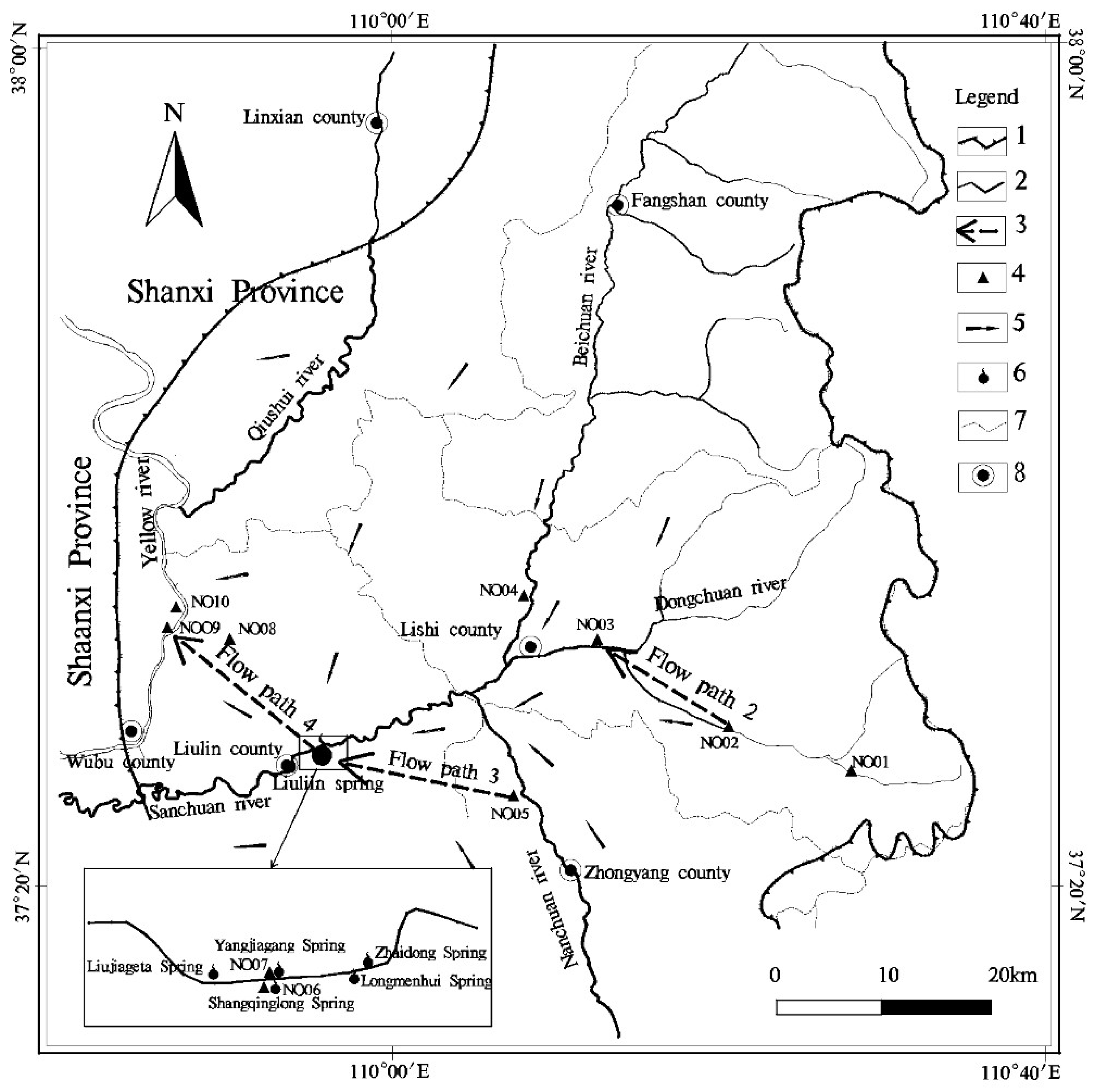
2. Study Area
3. Methodology
4. Sampling and Analysis
5. Results and Discussion
5.1. Water Chemical Characteristics
5.2. Inverse Hydrogeochemical Simulation
5.2.1. Choice of Simulation Path
- Flow path1: Precipitation → Youfangping
- Flow path2: Youfangping + Surface water → Tianjiahui
- Flow path3: Jinluo + Surface water→ Shangqinglong
- Flow path4: Yangjiagang + Henggou1#(1979) → Henggou1#(2011)
5.2.2. Determination of Mineral Phases
5.2.3. Establishment of Simulation Model
5.2.4. Modeling Results and Discussion
5.3. The Evolutionary Trends of Karst Groundwater Chemical Components in Focal Area
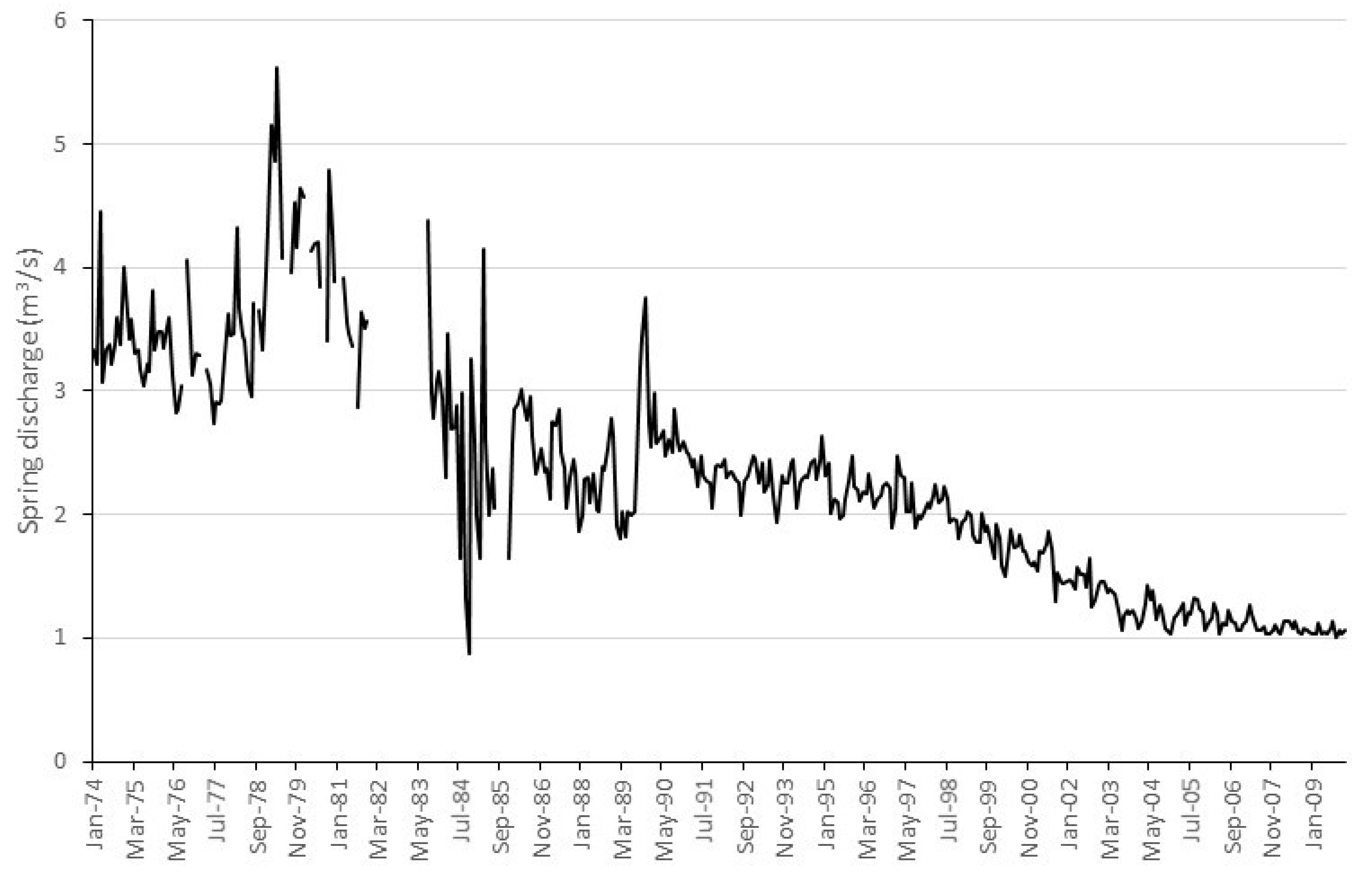
5.3.1. The Effect of Decreased Surface Leakage on Water Chemical Components in Liulin Springs
5.3.2. The Effect of Henggou Artesian Well on Karst Groundwater System
6. Conclusions
- Dissolution of Calcite mainly occurred during rainfall infiltration processes in the recharge area and precipitated along the whole flow path. While the dissolution of dolomite, gypsum and halite accompanied entire flow path and maximum dissolution load occurred in stagnant area.
- Results simulated by forward model showed that TDS of the Liulin springs will increase along with decreasing surface water leakage, while these value for karst groundwater near Henggou area will decrease accompanying by continuous discharge of the Henggou artesian well.
- This paper focus on spatial variation of major ionic concentrations. The temporal variation of ionic concentration need further study.
Author Contributions
Funding
Acknowledgments
Conflicts of Interest
References
- Han, X.R. Karst Hydrogeology; Geological Publishing House: Beijing, China, 2015. (In Chinese) [Google Scholar]
- Zheng, X.Q. An Investigation Report for Impact of Hengou Artesian Well in Wubu County on Liulin Springs; Taiyuan University of Technology: Taiyuan, China, 2012. (In Chinese) [Google Scholar]
- Gao, B.P.; Liang, Y.P.; Wang, W.T. Features of karst water and geologic background in Liulin spring basin. Carsol. Sin. 2008, 27, 209–214. (In Chinese) [Google Scholar]
- Wu, J.C.; Xue, Y.Q.; Huang, H.; Zhang, Z.Z.; Wang, Y.H. Three dimensional numerical simulation for solute transport in fracture-developed area in Liulin Springs, Shanxi Province. J. Nanjing. Univ. (Nat. Sci.) 2000, 36, 728–734. (In Chinese) [Google Scholar]
- Wu, J.C.; Xue, Y.Q.; Huang, H.; Zhang, Z.Z. Two dimensional numerical simulation of solute transport in Liulin spring local area. J. Hydraul. Eng. 2001, 32, 38–43. (In Chinese) [Google Scholar]
- Wu, J.C.; Xue, Y.Q.; Huang, H.; Zhang, Z.Z.; Wang, Y.H. Karst groundwater simulation of Liulin spring area, Shanxi province. Hydrogeol. Eng. Geol. 2001, 28, 18–20. (In Chinese) [Google Scholar]
- Hou, G.C.; Zhang, M.S. Groundwater Exploration in the Ordos Basin; Geology Publishing House: Beijing, China, 2001. (In Chinese) [Google Scholar]
- Plummer, L.N.; Busby, J.F.; Lee, R.W.; Hanshaw, B.B. Geochemical modeling of the Madison Aquifer in parts of Montana, Wyoming and South Dakota. Water Resour. Res. 1990, 26, 1981–2014. [Google Scholar] [CrossRef]
- Marfia, A.M.; Krishnamurthy, R.V.; Atekwana, E.A.; Panton, W.F. Isotopic and geochemical evolution of ground and surface waters in a karst dominated geological setting: A case study from Belize, Central America. Appl. Geochem. 2004, 19, 937–946. [Google Scholar] [CrossRef]
- Merkel, B.J.; Friedrich, B.P. Groundwater Geochemistry—A Practical Guide to Modeling of Natural and Contaminated Aquatic Systems; Springer: Berlin, Germany, 2005. [Google Scholar]
- Moral, F.; Cruz-Sanjulian, J.J.; Olias, M. Geochemical evolution of groundwater in the carbonate aquifers of Sierra de Segura (Betic Cordillera, southern Spain). J. Hydrol. 2008, 360, 281–296. [Google Scholar] [CrossRef]
- Ahmed, A.; Clark, I. Groundwater flow and geochemical evolution in the Central Flinders Ranges, South Australia. SciI. Total Environ. 2016, 572, 837–851. [Google Scholar] [CrossRef] [PubMed]
- Gastmans, D.; Hutcheon, I.; Menegario, A.A.; Chang, H.K. Geochemical evolution of groundwater in a basaltic aquifer based on chemical and stable isotopic data: Case study from the Northeastern portion of Serra Geral Aquifer, São Paulo state (Brazil). J. Hydrol. 2016, 535, 598–611. [Google Scholar] [CrossRef]
- Wang, Y.X.; Ma, T.; Luo, C.H.; Li, Y.M. Geochemical modeling of water-rock interactions in the Liulin karst system, Shanxi province. Earth Sci. J. China Univ. Geosci. 1998, 23, 519–522. (In Chinese) [Google Scholar]
- Wang, Y.X.; Ma, T.; Luo, C.H. Geostatistical and geochemical analysis of surface water leakage into groundwater on a regional scale: A case study in the Liulin karst system, northwestern China. J. Hydrol. 2001, 246, 223–234. [Google Scholar] [CrossRef]
- Ma, T.; Wang, Y.X.; Zhang, Q.B. A grey system approach to prediction of surface runoff leakage: With a example from the Liulin karst water system in Shanxi province. Earth Sci. J. China Univ. Geosci. 1997, 22, 90–93. (In Chinese) [Google Scholar]
- Ma, T.; Wang, Y.X. The analysis of water chemical information of groundwater using factor and Kriging analysis in the Liulin spring area in Shanxi province. Hydrogeol. Eng. Geol. 1999, 42, 44–46. (In Chinese) [Google Scholar]
- Ma, T.; Wang, Y.X.; Guo, Q.H.; Zheng, H. Hydrochemical and isotopic evidence of origin of thermal karst water at Taiyuan, northern China. J. Earth Sci. 2009, 20, 879–889. [Google Scholar] [CrossRef]
- Zang, H.F.; Zheng, X.Q.; Jia, Z.X.; Chen, J.F.; Qin, Z.D. The impact of hydrogeochemical processes on karst groundwater quality in arid and semiarid area: A case study in the Liulin spring area, north China. Arab. J. Geosci. 2015, 8, 6507–6519. [Google Scholar] [CrossRef]
- Zang, H.F.; Zheng, X.Q.; Qin, Z.D.; Jia, Z.X. A study of the characteristics of karst groundwater circulation based on multi-isotope approach in the Liulin spring area, North China. Isot. Environ. Healt Stud. 2015, 51, 271–284. [Google Scholar] [CrossRef] [PubMed]
- Plummer, L.N.; Prestemon, E.C.; Parkhurst, D.L. An Interactive Code (NETPATH) for Modeling Net Geochemical Reactions along a Flow Path; Water-Resources Investigations Report 94-4169; U.S. Geological Survey: Reston, VA, USA, 1994.
- El-Kadi, I.A.; Plummer, L.N.; Aggarwal, P. NETPATH-WIN: An interactive user version of the mass-balance model, NETPATH. Groundwater 2011, 49, 593–599. [Google Scholar] [CrossRef] [PubMed]
- Gran, G. Determination of the equivalence point in potentiometric titrations. Analyst 1952, 77, 661–671. [Google Scholar] [CrossRef]
- Zhang, X.F.; Hu, W.X.; Zhang, J.T. Critical problems for dolomite formation and dolomitization models. Geol. Sci. Technol. Inf. 2006, 25, 32–40. (In Chinese) [Google Scholar]
- Liu, Z.H.; Dreybrodt, W.; Li, H.J. Comparison of dissolution rate-determining mechanisms between limestone and dolomite. Earth Sci. J. China Univ. Geosci. 2006, 31, 411–416. (In Chinese) [Google Scholar]
- Back, W.; Hanshaw, B.B.; Plummer, L.N.; Rahn, P.H.; Rightmire, C.T.; Rubin, M. Process and rate of dedolomitization: Mass transfer and 14C dating in a regional carbonate aquifer. Geol. Soc. Am. Bull. 1983, 94, 1415–1429. [Google Scholar] [CrossRef]
- Hanshaw, B.B.; Back, W. Major geochemical processes in the evolution of carbonate-aquifer systems. J. Hydrol. 1979, 43, 287–312. [Google Scholar] [CrossRef]
- Lopez, C.M.; Bouamama, M.; Vallejos, A.; Pulido, B.A. Factors which determine the hydrogeochemical behaviour of karstic springs. A case study from the Betic Cordilleras, Spain. Appl. Geochem. 2001, 16, 1179–1192. [Google Scholar] [CrossRef]


| NO. | Sampling Sites | Year | Water Types | Sub-Region | T (°C) | Eh (pV) | pH | Na+ | Ca2+ | Mg2+ | Cl− | SO42− | HCO3− |
|---|---|---|---|---|---|---|---|---|---|---|---|---|---|
| NO01 | Wucheng | 2011 | Karst groundwater | Recharge area | 12.00 | 2.74 | 7.66 | 11.3 | 62.1 | 19.4 | 6.03 | 29.8 | 277 |
| NO02 | Youfangping | 2011 | Karst groundwater | Recharge area | 11.00 | 2.77 | 7.78 | 18.4 | 64.5 | 19.9 | 10.6 | 43.2 | 278 |
| NO03 | Tianjiahui | 2011 | Karst groundwater | Flow-through area | 17.00 | 2.08 | 7.93 | 41.2 | 60.5 | 17.7 | 36.2 | 35.5 | 277 |
| NO04 | Shangan | 2011 | Karst groundwater | Flow-through area | 11.50 | 4.09 | 7.58 | 49.2 | 66.9 | 25.8 | 31.2 | 86.5 | 277 |
| NO05 | Jinluo | 2011 | Karst groundwater | Flow-through area | 16.00 | 2.11 | 7.54 | 41.5 | 57.3 | 43 | 3.54 | 113 | 271 |
| NO06 | Shangqinglong | 2011 | Karst groundwater | Discharge area | 16.00 | 2.86 | 7.63 | 81.5 | 66.9 | 24.8 | 51.8 | 90.3 | 271 |
| NO07 | Yangjiagang | 2011 | Karst groundwater | Discharge area | 15.00 | 2.75 | 7.6 | 174 | 123 | 27.2 | 172 | 280 | 320 |
| NO08 | Baijiayan | 2011 | Karst groundwater | Stagnant area | 22.50 | 1.20 | 7.19 | 445 | 180 | 69.3 | 568 | 377 | 303 |
| NO09 | Henggou1# | 2011 | Karst groundwater | Stagnant area | 33.00 | −4.88 | 6.84 | 2240 | 749 | 190 | 3550 | 1780 | 235 |
| NO10 | Henggou2# | 2011 | Karst groundwater | Stagnant area | 35.00 | −4.43 | 6.93 | 1760 | 552 | 229 | 2720 | 1640 | 246 |
| NO11 | Lishi meteorological station | 2009 | Precipitation | - | 10 | 4.00 | 7.1 | 4.4 | 6.5 | 2.0 | 1.5 | 10.4 | 25.1 |
| NO12 | Sanchuan River | 1995 | Surfaces water | - | 21.8 | 4.00 | 6.8 | 11.1 | 41.0 | 12.8 | 9.3 | 30.4 | 174.2 |
| NO13 | Hengou 1# | 1979 | Karst groundwater | Stagnant area | 36.0 | - | - | 3030 | 1057 | 260 | 4893 | 2698 | 212 |
| NO. | Models | Mixture Proportion | Transferring Molar Concentration of Mineral Phases (mmol/L) | ||||||||
|---|---|---|---|---|---|---|---|---|---|---|---|
| Calcite | Dolomite | Gypsum | Halite | CO2(g) | CaX2 | MgX2 | NaX | ||||
| The flow path 1 | Model 1 | / | / | 0.26 | 1.02 | 0.31 | 0.25 | 2.85 | / | −0.21 | 0.42 |
| Model 2 | / | / | 0.68 | 0.81 | 0.31 | 0.25 | 2.85 | −0.21 | / | 0.42 | |
| The flow path 2 | Model 1 | 0.51 | 0.49 | / | 0.22 | / | 0.70 | −0.04 | −0.06 | −0.19 | 0.50 |
| Model 2 | 0.27 | 0.73 | / | 0.34 | 0.03 | 0.71 | / | −0.06 | −0.23 | 0.57 | |
| Model 3 | 0.51 | 0.49 | −0.12 | 0.29 | / | 0.70 | −0.04 | / | −0.25 | 0.50 | |
| Model 4 | 0.27 | 0.73 | −0.12 | 0.40 | 0.03 | 0.71 | / | / | −0.28 | 0.57 | |
| The flow path 3 | Model 1 | 0.58 | 0.42 | / | 0.23 | 0.14 | 1.31 | −0.08 | / | −0.48 | 0.97 |
| Model 2 | 0.58 | 0.42 | / | 0.23 | 0.14 | 1.31 | / | / | −0.48 | 0.97 | |
| Model 3 | 0.00 | 1.00 | / | 0.61 | 0.66 | 1.22 | −0.21 | −0.72 | −0.17 | 1.79 | |
| The flow path 4 | Model 1 | 0.87 | 0.13 | −0.59 | / | 12.68 | 82.67 | −0.41 | 0.29 | 5.55 | −11.68 |
| Model 2 | 0.87 | 0.13 | −11.68 | 5.55 | 12.68 | 82.67 | −0.41 | 5.84 | / | −11.68 | |
| Components | Shangqinglong | Henggou | ||||
|---|---|---|---|---|---|---|
| Observed Value | Prediction Value | Increasing Rate (%) | Observed Value | Prediction Value | Increasing Rate (%) | |
| HCO3− | 5.418 | 5.854 | 8% | 4.74 | 6.57 | 39% |
| Ca2+ | 1.670 | 2.553 | 53% | 18.85 | 7.88 | −58% |
| Cl− | 1.462 | 6.108 | 318% | 101.00 | 87.49 | −13% |
| Mg2+ | 1.021 | 0.891 | −13% | 7.88 | 8.84 | 12% |
| Na+ + K+ | 3.547 | 7.815 | 120% | 98.29 | 90.21 | −8% |
| SO42− | 0.941 | 1.312 | 40% | 18.69 | 15.59 | −17% |
© 2018 by the authors. Licensee MDPI, Basel, Switzerland. This article is an open access article distributed under the terms and conditions of the Creative Commons Attribution (CC BY) license (http://creativecommons.org/licenses/by/4.0/).
Share and Cite
Zheng, X.; Zang, H.; Zhang, Y.; Chen, J.; Zhang, F.; Shen, Y. A Study of Hydrogeochemical Processes on Karst Groundwater Using a Mass Balance Model in the Liulin Spring Area, North China. Water 2018, 10, 903. https://doi.org/10.3390/w10070903
Zheng X, Zang H, Zhang Y, Chen J, Zhang F, Shen Y. A Study of Hydrogeochemical Processes on Karst Groundwater Using a Mass Balance Model in the Liulin Spring Area, North China. Water. 2018; 10(7):903. https://doi.org/10.3390/w10070903
Chicago/Turabian StyleZheng, Xiuqing, Hongfei Zang, Yongbo Zhang, Junfeng Chen, Fei Zhang, and Yu Shen. 2018. "A Study of Hydrogeochemical Processes on Karst Groundwater Using a Mass Balance Model in the Liulin Spring Area, North China" Water 10, no. 7: 903. https://doi.org/10.3390/w10070903